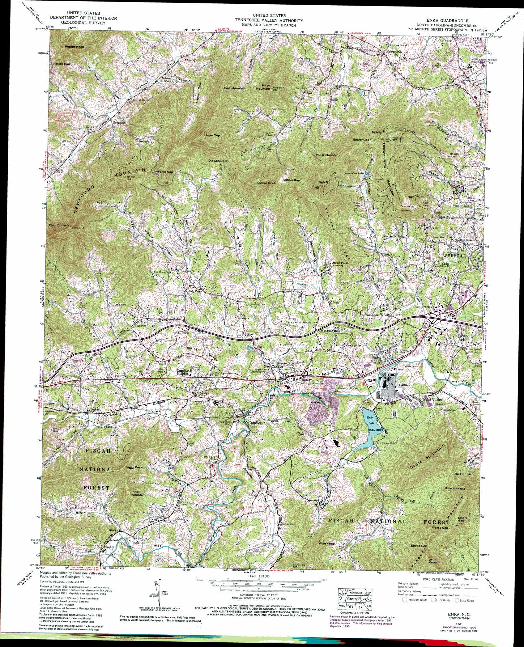
Enka Topo Map North Carolina
To zoom in, hover over the map of Enka
USGS Topo Quad 35082e6 - 1:24,000 scale
| Topo Map Name: | Enka |
| USGS Topo Quad ID: | 35082e6 |
| Print Size: | ca. 21 1/4" wide x 27" high |
| Southeast Coordinates: | 35.5° N latitude / 82.625° W longitude |
| Map Center Coordinates: | 35.5625° N latitude / 82.6875° W longitude |
| U.S. State: | NC |
| Filename: | o35082e6.jpg |
| Download Map JPG Image: | Enka topo map 1:24,000 scale |
| Map Type: | Topographic |
| Topo Series: | 7.5´ |
| Map Scale: | 1:24,000 |
| Source of Map Images: | United States Geological Survey (USGS) |
| Alternate Map Versions: |
Enka NC 1936 Download PDF Buy paper map Enka NC 1941, updated 1956 Download PDF Buy paper map Enka NC 1942 Download PDF Buy paper map Enka NC 1942 Download PDF Buy paper map Enka NC 1961, updated 1965 Download PDF Buy paper map Enka NC 1961, updated 1972 Download PDF Buy paper map Enka NC 1961, updated 1972 Download PDF Buy paper map Enka NC 1961, updated 1991 Download PDF Buy paper map Enka NC 1976, updated 1979 Download PDF Buy paper map Enka NC 1998, updated 2001 Download PDF Buy paper map Enka NC 2011 Download PDF Buy paper map Enka NC 2013 Download PDF Buy paper map Enka NC 2016 Download PDF Buy paper map |
| FStopo: | US Forest Service topo Enka is available: Download FStopo PDF Download FStopo TIF |
1:24,000 Topo Quads surrounding Enka
Lemon Gap |
Spring Creek |
Marshall |
Mars Hill |
Barnardsville |
Fines Creek |
Sandymush |
Leicester |
Weaverville |
Craggy Pinnacle |
Clyde |
Canton |
Enka |
Asheville |
Oteen |
Waynesville |
Cruso |
Dunsmore Mountain |
Skyland |
Fruitland |
Sam Knob |
Shining Rock |
Pisgah Forest |
Horse Shoe |
Hendersonville |
> Back to 35082e1 at 1:100,000 scale
> Back to 35082a1 at 1:250,000 scale
> Back to U.S. Topo Maps home
Enka topo map: Gazetteer
Enka: Dams
Enka Lake Dam elevation 638m 2093′J and J Trout Lake elevation 762m 2500′
Starnes Cove Fishing Lake Dam elevation 738m 2421′
Thrash Dam elevation 712m 2335′
Enka: Gaps
Baldwin Gap elevation 738m 2421′Dix Creek Gap elevation 867m 2844′
Hooker Gap elevation 904m 2965′
Luther Gap elevation 864m 2834′
Mease Gap elevation 823m 2700′
Moors Gap elevation 848m 2782′
Potato Gap elevation 800m 2624′
Sheep Gap elevation 893m 2929′
Spivey Gap elevation 868m 2847′
Enka: Parks
Beaverdam Wildlife Restoration Area elevation 705m 2312′Enka: Populated Places
Acton elevation 656m 2152′Candler elevation 647m 2122′
Candler Heights elevation 686m 2250′
Enka elevation 631m 2070′
Enka Village elevation 642m 2106′
Georgetown elevation 670m 2198′
Glady elevation 686m 2250′
Hominy elevation 651m 2135′
Jugtown elevation 700m 2296′
Luther elevation 666m 2185′
New Candler elevation 642m 2106′
Newfound elevation 659m 2162′
Owltown elevation 765m 2509′
Pole Creek elevation 681m 2234′
Sand Hill elevation 671m 2201′
Woodside Hills elevation 679m 2227′
Enka: Reservoirs
Enka Lake elevation 638m 2093′J and J Fishing Lake elevation 762m 2500′
Starnes Cove Lakes elevation 738m 2421′
Thrash Lake elevation 712m 2335′
Enka: Ridges
Justice Ridge elevation 700m 2296′Starnes Ridge elevation 810m 2657′
Enka: Streams
Baldwin Field Branch elevation 663m 2175′Beaverdam Creek elevation 637m 2089′
Bill Moore Creek elevation 628m 2060′
Brooks Branch elevation 651m 2135′
Bryson Branch elevation 651m 2135′
Curtis Creek elevation 682m 2237′
George Branch elevation 663m 2175′
Little Pole Creek elevation 639m 2096′
Moore Creek elevation 626m 2053′
Morgan Branch elevation 656m 2152′
Morgan Branch elevation 680m 2230′
Pole Creek elevation 632m 2073′
South Hominy Creek elevation 639m 2096′
Webb Branch elevation 650m 2132′
Wise Branch elevation 641m 2103′
Young Branch elevation 635m 2083′
Enka: Summits
Bert Mountain elevation 966m 3169′Deaver View Mountain elevation 1010m 3313′
Hayes Top elevation 1104m 3622′
High Point elevation 944m 3097′
High Top elevation 1051m 3448′
Luther Knob elevation 1021m 3349′
Miller Mountain elevation 1025m 3362′
Peggy Peak elevation 911m 2988′
Piney Mountain elevation 958m 3143′
Piney Mountain elevation 886m 2906′
Potato Knob elevation 911m 2988′
Rice Pinnacle elevation 895m 2936′
Scott Mountain elevation 904m 2965′
Spivey Mountain elevation 1007m 3303′
The Pinnacle elevation 1193m 3914′
Wise Knob elevation 867m 2844′
Wolf Knob elevation 985m 3231′
Enka: Valleys
Big Cove elevation 686m 2250′Brooks Cove elevation 662m 2171′
Case Cove elevation 641m 2103′
Cowan Cove elevation 661m 2168′
Hayes Cove elevation 639m 2096′
Herren Cove elevation 672m 2204′
Holcombe Cove elevation 626m 2053′
Luther Cove elevation 667m 2188′
Milksick Cove elevation 674m 2211′
Morgan Cove elevation 660m 2165′
Starnes Cove elevation 666m 2185′
Young Cove elevation 655m 2148′
Enka digital topo map on disk
Buy this Enka topo map showing relief, roads, GPS coordinates and other geographical features, as a high-resolution digital map file on DVD:
South Carolina, Western North Carolina & Northeastern Georgia
Buy digital topo maps: South Carolina, Western North Carolina & Northeastern Georgia