Marion West Topo Map North Carolina
To zoom in, hover over the map of Marion West
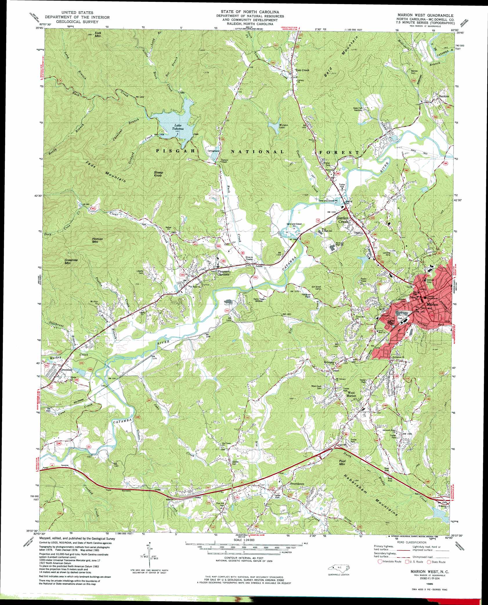
USGS Topo Quad 35082f1 - 1:24,000 scale
| Topo Map Name: | Marion West |
| USGS Topo Quad ID: | 35082f1 |
| Print Size: | ca. 21 1/4" wide x 27" high |
| Southeast Coordinates: | 35.625° N latitude / 82° W longitude |
| Map Center Coordinates: | 35.6875° N latitude / 82.0625° W longitude |
| U.S. State: | NC |
| Filename: | o35082f1.jpg |
| Download Map JPG Image: | Marion West topo map 1:24,000 scale |
| Map Type: | Topographic |
| Topo Series: | 7.5´ |
| Map Scale: | 1:24,000 |
| Source of Map Images: | United States Geological Survey (USGS) |
| Alternate Map Versions: |
Marion West NC 1985, updated 1986 Download PDF Buy paper map Marion West NC 1994, updated 1998 Download PDF Buy paper map Marion West NC 2011 Download PDF Buy paper map Marion West NC 2013 Download PDF Buy paper map Marion West NC 2016 Download PDF Buy paper map |
| FStopo: | US Forest Service topo Marion West is available: Download FStopo PDF Download FStopo TIF |
1:24,000 Topo Quads surrounding Marion West
Burnsville |
Micaville |
Spruce Pine |
Linville Falls |
Chestnut Mountain |
Mount Mitchell |
Celo |
Little Switzerland |
Ashford |
Oak Hill |
Montreat |
Old Fort |
Marion West |
Marion East |
Glen Alpine |
Black Mountain |
Moffitt Hill |
Sugar Hill |
Glenwood |
Dysartsville |
Bat Cave |
Lake Lure |
Shingle Hollow |
Rutherfordton North |
Sunshine |
> Back to 35082e1 at 1:100,000 scale
> Back to 35082a1 at 1:250,000 scale
> Back to U.S. Topo Maps home
Marion West topo map: Gazetteer
Marion West: Airports
Shiflet Field elevation 367m 1204′Marion West: Dams
Lake Tahoma Dam elevation 410m 1345′Morgan Dam elevation 426m 1397′
Marion West: Populated Places
Garden Creek elevation 374m 1227′Greenlee elevation 419m 1374′
Hankins elevation 395m 1295′
Marion elevation 436m 1430′
Pleasant Gardens elevation 418m 1371′
Providence elevation 463m 1519′
Toms Creek elevation 446m 1463′
West Marion elevation 447m 1466′
Marion West: Post Offices
Marion Post Office elevation 430m 1410′Marion West: Ranges
Habersham Mountains elevation 560m 1837′Marion West: Reservoirs
Lake Tahoma elevation 410m 1345′Morgan Lake elevation 426m 1397′
Marion West: Streams
Beatty Branch elevation 385m 1263′Bee Branch elevation 443m 1453′
Buck Creek elevation 375m 1230′
Cane Creek elevation 391m 1282′
Chestnut Branch elevation 432m 1417′
Clear Creek elevation 383m 1256′
Crooked Creek elevation 399m 1309′
Deep Cove Creek elevation 507m 1663′
Glades Creek elevation 396m 1299′
Jake Creek elevation 386m 1266′
Johns Creek elevation 369m 1210′
Little Buck Creek elevation 434m 1423′
Long Branch elevation 478m 1568′
Long Branch elevation 489m 1604′
Mackey Creek elevation 390m 1279′
McGegers Branch elevation 372m 1220′
Nix Creek elevation 376m 1233′
Orchard Creek elevation 430m 1410′
Paxton Creek elevation 389m 1276′
Reedy Branch elevation 461m 1512′
South Fork Toms Creek elevation 445m 1459′
Stillhouse Branch elevation 390m 1279′
Toms Creek elevation 373m 1223′
Marion West: Summits
Bald Mountain elevation 669m 2194′Feds Mountain elevation 685m 2247′
Fork Mountain elevation 881m 2890′
Greenlee Mountain elevation 949m 3113′
Hoover Mountain elevation 823m 2700′
Pool Mountain elevation 522m 1712′
Sheep Knob elevation 716m 2349′
Marion West digital topo map on disk
Buy this Marion West topo map showing relief, roads, GPS coordinates and other geographical features, as a high-resolution digital map file on DVD:
South Carolina, Western North Carolina & Northeastern Georgia
Buy digital topo maps: South Carolina, Western North Carolina & Northeastern Georgia