Craggy Pinnacle Topo Map North Carolina
To zoom in, hover over the map of Craggy Pinnacle
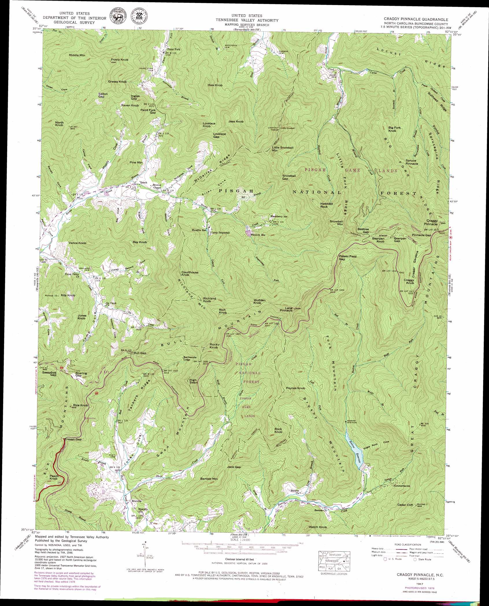
USGS Topo Quad 35082f4 - 1:24,000 scale
| Topo Map Name: | Craggy Pinnacle |
| USGS Topo Quad ID: | 35082f4 |
| Print Size: | ca. 21 1/4" wide x 27" high |
| Southeast Coordinates: | 35.625° N latitude / 82.375° W longitude |
| Map Center Coordinates: | 35.6875° N latitude / 82.4375° W longitude |
| U.S. State: | NC |
| Filename: | o35082f4.jpg |
| Download Map JPG Image: | Craggy Pinnacle topo map 1:24,000 scale |
| Map Type: | Topographic |
| Topo Series: | 7.5´ |
| Map Scale: | 1:24,000 |
| Source of Map Images: | United States Geological Survey (USGS) |
| Alternate Map Versions: |
Craggy Pinnacle NC 1935 Download PDF Buy paper map Craggy Pinnacle NC 1946, updated 1972 Download PDF Buy paper map Craggy Pinnacle NC 1946, updated 1978 Download PDF Buy paper map Craggy Pinnacle NC 1947, updated 1947 Download PDF Buy paper map Craggy Pinnacle NC 1947, updated 1947 Download PDF Buy paper map Craggy Pinnacle NC 1947, updated 1947 Download PDF Buy paper map Craggy Pinnacle NC 1947, updated 1965 Download PDF Buy paper map Craggy Pinnacle NC 1947, updated 1979 Download PDF Buy paper map Craggy Pinnacle NC 1947, updated 1979 Download PDF Buy paper map Craggy Pinnacle NC 1997, updated 2001 Download PDF Buy paper map Craggy Pinnacle NC 2011 Download PDF Buy paper map Craggy Pinnacle NC 2013 Download PDF Buy paper map Craggy Pinnacle NC 2016 Download PDF Buy paper map |
| FStopo: | US Forest Service topo Craggy Pinnacle is available: Download FStopo PDF Download FStopo TIF |
1:24,000 Topo Quads surrounding Craggy Pinnacle
White Rock |
Sams Gap |
Bald Creek |
Burnsville |
Micaville |
Marshall |
Mars Hill |
Barnardsville |
Mount Mitchell |
Celo |
Leicester |
Weaverville |
Craggy Pinnacle |
Montreat |
Old Fort |
Enka |
Asheville |
Oteen |
Black Mountain |
Moffitt Hill |
Dunsmore Mountain |
Skyland |
Fruitland |
Bat Cave |
Lake Lure |
> Back to 35082e1 at 1:100,000 scale
> Back to 35082a1 at 1:250,000 scale
> Back to U.S. Topo Maps home
Craggy Pinnacle topo map: Gazetteer
Craggy Pinnacle: Areas
Craggy Mountain Scenic Area elevation 1236m 4055′Craggy Pinnacle: Dams
Bee Tree Lake Dam elevation 789m 2588′Woodfin Reservoir Dam elevation 957m 3139′
Craggy Pinnacle: Falls
Douglas Falk elevation 1053m 3454′Craggy Pinnacle: Gaps
Bearpen Gap elevation 1590m 5216′Beetree Gap elevation 1490m 4888′
Bull Gap elevation 960m 3149′
Craven Gap elevation 952m 3123′
Ingles Gap elevation 1007m 3303′
Jack Gap elevation 958m 3143′
Lovelace Gap elevation 1178m 3864′
Paint Fork Gap elevation 945m 3100′
Pinnacle Gap elevation 1655m 5429′
Potato Field Gap elevation 1395m 4576′
Roaring Gap elevation 1096m 3595′
Salton Gap elevation 1130m 3707′
Sassafras Gap elevation 1091m 3579′
Snowball Gap elevation 1327m 4353′
Craggy Pinnacle: Populated Places
Beech elevation 735m 2411′Blackberry Inn elevation 998m 3274′
Paint Fork elevation 752m 2467′
Rattlesnake Lodge elevation 1132m 3713′
Riceville elevation 696m 2283′
Summerhaven elevation 831m 2726′
Craggy Pinnacle: Ranges
Copperas Mountain elevation 963m 3159′Great Craggy Mountains elevation 1630m 5347′
Craggy Pinnacle: Reservoirs
Bee Tree Reservoir elevation 789m 2588′Beetree Reservoir elevation 817m 2680′
Woodfin Reservoir elevation 957m 3139′
Craggy Pinnacle: Ridges
Big Fork Ridge elevation 1478m 4849′Craggy Gardens elevation 1684m 5524′
Little Fork Ridge elevation 1380m 4527′
Locust Ridge elevation 1146m 3759′
McDaires Ridge elevation 1022m 3353′
Sprucepine Ridge elevation 1343m 4406′
Tanbark Ridge elevation 932m 3057′
Craggy Pinnacle: Streams
Alexander Branch elevation 770m 2526′Bearwallow Branch elevation 1028m 3372′
Bee Branch elevation 868m 2847′
Bell Branch elevation 984m 3228′
Carter Creek elevation 777m 2549′
Gregg Branch elevation 691m 2267′
Hawkbill Creek elevation 852m 2795′
Jimmy Branch elevation 699m 2293′
Keasler Branch elevation 698m 2290′
Laurel Fork elevation 807m 2647′
Left Fork Beetree Creek elevation 813m 2667′
Long Branch elevation 697m 2286′
Maney Branch elevation 731m 2398′
Mineral Creek elevation 777m 2549′
Peach Orchard Creek elevation 910m 2985′
Right Fork Beetree Creek elevation 925m 3034′
Sawmill Branch elevation 847m 2778′
Shope Creek elevation 685m 2247′
Spruce Fork elevation 749m 2457′
Sugarcamp Fork elevation 919m 3015′
Waterfall Creek elevation 993m 3257′
Wolf Branch elevation 808m 2650′
Wolfe Branch elevation 865m 2837′
Craggy Pinnacle: Summits
Alexander Knob elevation 1384m 4540′Bartlett Mountain elevation 1010m 3313′
Bearpen Knob elevation 1605m 5265′
Big Fork Knob elevation 1366m 4481′
Brushy Mountain elevation 1048m 3438′
Bull Mountain elevation 1484m 4868′
Cedar Cliff elevation 1148m 3766′
Courthouse Knob elevation 1322m 4337′
Craggy Knob elevation 1696m 5564′
Craggy Pinnacle elevation 1773m 5816′
Fork Mountain elevation 1222m 4009′
Frosty Knob elevation 1291m 4235′
Grassy Knob elevation 1226m 4022′
Haw Knob elevation 1215m 3986′
Hawkbill Rock elevation 1484m 4868′
High Swan elevation 1291m 4235′
Jess Knob elevation 1338m 4389′
Jones Knob elevation 933m 3061′
Kits Knob elevation 950m 3116′
Lane Pinnacle elevation 1583m 5193′
Little Snowball Mountain elevation 1430m 4691′
Lovelace Knob elevation 1280m 4199′
Middle Mountain elevation 1253m 4110′
North Knob elevation 1233m 4045′
Paynes Knob elevation 1185m 3887′
Peach Knob elevation 1154m 3786′
Pine Mountain elevation 904m 2965′
Raven Knob elevation 1102m 3615′
Ray Knob elevation 1010m 3313′
Rice Knob elevation 1199m 3933′
Rich Knob elevation 1500m 4921′
Richland Knob elevation 1438m 4717′
Richland Mountain elevation 1438m 4717′
Rock Knob elevation 1199m 3933′
Rocky Knob elevation 1434m 4704′
Snowball Mountain elevation 1628m 5341′
Spruce Pinnacle elevation 1423m 4668′
Swan Mountain elevation 1027m 3369′
Vance Knob elevation 969m 3179′
Watch Knob elevation 970m 3182′
Wolfden Knob elevation 1505m 4937′
Craggy Pinnacle: Swamps
Craggy Flats elevation 1730m 5675′Craggy Pinnacle: Valleys
Ballard Cove elevation 776m 2545′Barrett Cove elevation 687m 2253′
Camel Field elevation 740m 2427′
Eagle Rock Cove elevation 812m 2664′
Eller Cove elevation 798m 2618′
Honeycut Cove elevation 762m 2500′
Jones Cove elevation 709m 2326′
Jump Cove elevation 724m 2375′
McDaires Cove elevation 751m 2463′
Moody Cove elevation 690m 2263′
Pennix Cove elevation 671m 2201′
Ray Cove elevation 718m 2355′
Sawyer Cove elevation 772m 2532′
Sugar Cove elevation 704m 2309′
Craggy Pinnacle digital topo map on disk
Buy this Craggy Pinnacle topo map showing relief, roads, GPS coordinates and other geographical features, as a high-resolution digital map file on DVD:
South Carolina, Western North Carolina & Northeastern Georgia
Buy digital topo maps: South Carolina, Western North Carolina & Northeastern Georgia