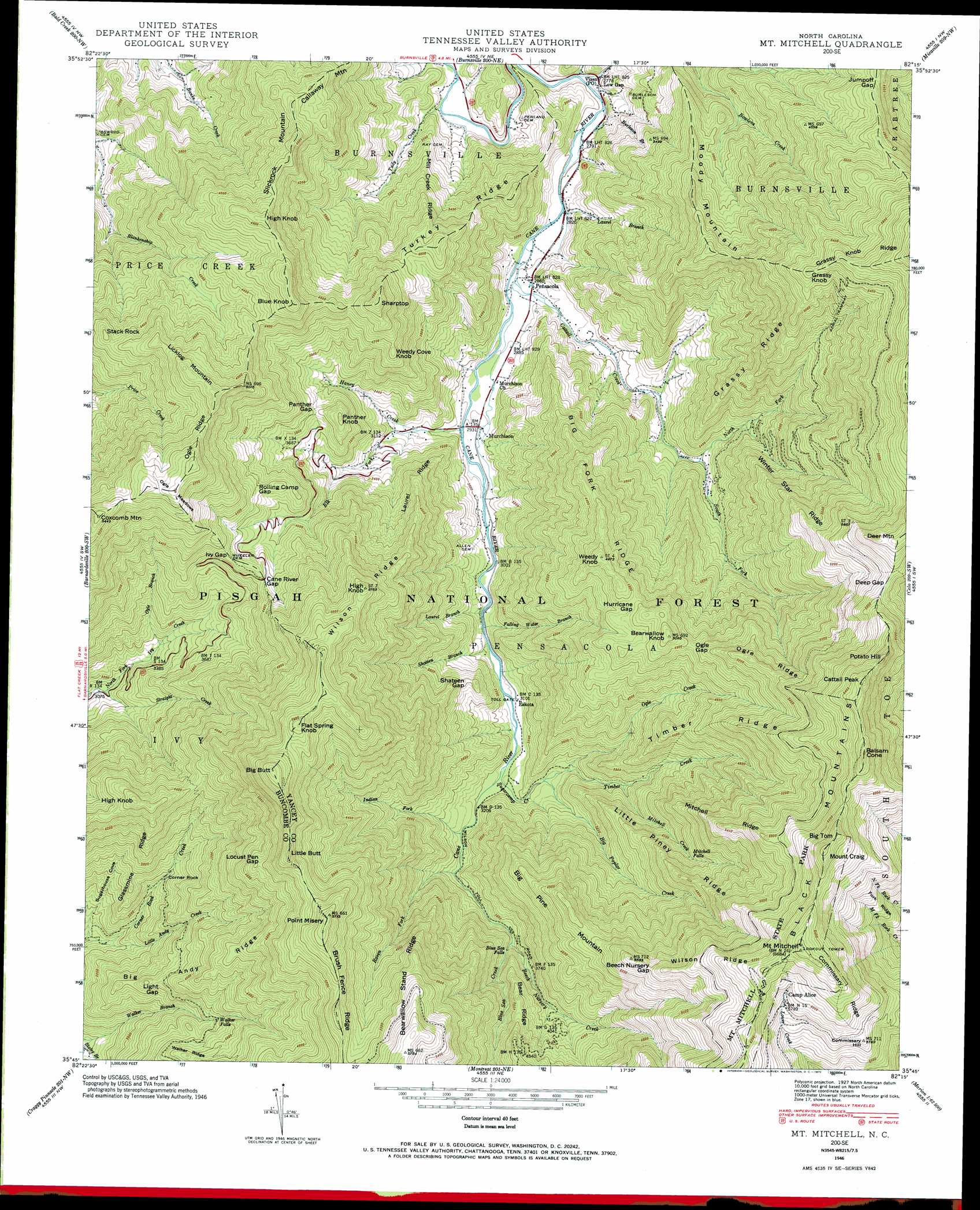
Mount Mitchell Topo Map North Carolina
To zoom in, hover over the map of Mount Mitchell
USGS Topo Quad 35082g3 - 1:24,000 scale
| Topo Map Name: | Mount Mitchell |
| USGS Topo Quad ID: | 35082g3 |
| Print Size: | ca. 21 1/4" wide x 27" high |
| Southeast Coordinates: | 35.75° N latitude / 82.25° W longitude |
| Map Center Coordinates: | 35.8125° N latitude / 82.3125° W longitude |
| U.S. State: | NC |
| Filename: | o35082g3.jpg |
| Download Map JPG Image: | Mount Mitchell topo map 1:24,000 scale |
| Map Type: | Topographic |
| Topo Series: | 7.5´ |
| Map Scale: | 1:24,000 |
| Source of Map Images: | United States Geological Survey (USGS) |
| Alternate Map Versions: |
Black Brothers NC 1935 Download PDF Buy paper map Mt. Mitchell NC 1946, updated 1957 Download PDF Buy paper map Mt. Mitchell NC 1946, updated 1959 Download PDF Buy paper map Mt. Mitchell NC 1946, updated 1971 Download PDF Buy paper map Mt. Mitchell NC 1946, updated 1988 Download PDF Buy paper map Mt. Mitchell NC 1946, updated 1988 Download PDF Buy paper map Black Brothers NC 1947, updated 1947 Download PDF Buy paper map Mount Mitchell NC 2011 Download PDF Buy paper map Mount Mitchell NC 2013 Download PDF Buy paper map Mount Mitchell NC 2016 Download PDF Buy paper map |
| FStopo: | US Forest Service topo Mount Mitchell is available: Download FStopo PDF Download FStopo TIF |
1:24,000 Topo Quads surrounding Mount Mitchell
Flag Pond |
Chestoa |
Huntdale |
Bakersville |
Carvers Gap |
Sams Gap |
Bald Creek |
Burnsville |
Micaville |
Spruce Pine |
Mars Hill |
Barnardsville |
Mount Mitchell |
Celo |
Little Switzerland |
Weaverville |
Craggy Pinnacle |
Montreat |
Old Fort |
Marion West |
Asheville |
Oteen |
Black Mountain |
Moffitt Hill |
Sugar Hill |
> Back to 35082e1 at 1:100,000 scale
> Back to 35082a1 at 1:250,000 scale
> Back to U.S. Topo Maps home
Mount Mitchell topo map: Gazetteer
Mount Mitchell: Airports
Mountain Wilderness Airpark elevation 878m 2880′Mount Mitchell: Falls
Blue Sea Falls elevation 1077m 3533′Mitchell Falls elevation 1511m 4957′
Walker Falls elevation 1142m 3746′
Mount Mitchell: Flats
Ogle Meadows elevation 1635m 5364′Mount Mitchell: Forests
Pisgah National Forest elevation 1531m 5022′Mount Mitchell: Gaps
Beech Nursery Gap elevation 1647m 5403′Cane River Gap elevation 1296m 4251′
Deep Gap elevation 1741m 5711′
Hurricane Gap elevation 1433m 4701′
Ivy Gap elevation 1307m 4288′
Jumpoff Gap elevation 1416m 4645′
Light Gap elevation 1134m 3720′
Locust Pen Gap elevation 1522m 4993′
Ogle Gap elevation 1446m 4744′
Panther Gap elevation 1150m 3772′
Rolling Camp Gap elevation 1295m 4248′
Shateen Gap elevation 1100m 3608′
Mount Mitchell: Parks
Mount Mitchell State Park elevation 1936m 6351′Mount Mitchell: Pillars
Corner Rock elevation 1021m 3349′Mount Mitchell: Populated Places
Cattail Creek Community elevation 1691m 5547′Eskota elevation 945m 3100′
Low Gap elevation 845m 2772′
Murchison elevation 893m 2929′
Pensacola elevation 870m 2854′
Mount Mitchell: Post Offices
Vixen Post Office (historical) elevation 845m 2772′Mount Mitchell: Ranges
Blue Ridge elevation 2002m 6568′Mount Mitchell: Ridges
Bear Ridge elevation 1424m 4671′Bearwallow Stand Ridge elevation 1666m 5465′
Big Andy Ridge elevation 1287m 4222′
Big Fork Ridge elevation 1432m 4698′
Black Mountains elevation 1964m 6443′
Brush Fence Ridge elevation 1634m 5360′
Commissary Ridge elevation 1943m 6374′
Glassmine Ridge elevation 1183m 3881′
Grassy Knob Ridge elevation 1751m 5744′
Grassy Ridge elevation 1361m 4465′
Laurel Ridge elevation 1200m 3937′
Little Piney Ridge elevation 1514m 4967′
Mill Creek Ridge elevation 1088m 3569′
Mitchell Ridge elevation 1673m 5488′
Ogle Ridge elevation 1573m 5160′
Ogle Ridge elevation 1576m 5170′
Timber Ridge elevation 1487m 4878′
Turkey Ridge elevation 1137m 3730′
Wilson Ridge elevation 1541m 5055′
Wilson Ridge elevation 1831m 6007′
Winter Star Ridge elevation 1464m 4803′
Mount Mitchell: Streams
Bee Branch elevation 841m 2759′Beech Nursery Creek elevation 1077m 3533′
Big Poplar Creek elevation 984m 3228′
Blue Sea Creek elevation 1077m 3533′
Burleson Branch elevation 846m 2775′
Cattail Creek elevation 882m 2893′
Elk Fork elevation 894m 2933′
Falling Water Branch elevation 938m 3077′
Haney Creek elevation 923m 3028′
Indian Fork elevation 989m 3244′
Laurel Branch elevation 930m 3051′
Laurel Branch elevation 859m 2818′
Little Andy Creek elevation 875m 2870′
Mitchell Creek elevation 1080m 3543′
North Fork Cattail Creek elevation 965m 3166′
Ogle Branch elevation 1026m 3366′
Ogle Creek elevation 1006m 3300′
Raven Fork elevation 1015m 3330′
Shateen Branch elevation 937m 3074′
South Fork Cattail Creek elevation 965m 3166′
Straight Creek elevation 939m 3080′
Sugarcamp Creek elevation 958m 3143′
Timber Creek elevation 1006m 3300′
Tudy Creek elevation 829m 2719′
Mount Mitchell: Summits
Balsam Cone elevation 2006m 6581′Bearwallow Knob elevation 1535m 5036′
Big Butt elevation 1813m 5948′
Big Pine Mountain elevation 1682m 5518′
Big Tom elevation 2002m 6568′
Blue Knob elevation 1497m 4911′
Callaway Mountain elevation 1331m 4366′
Cattail Peak elevation 1985m 6512′
Commissary Hill elevation 1760m 5774′
Coxcomb Mountain elevation 1654m 5426′
Deer Mountain elevation 1846m 6056′
Flat Spring Knob elevation 1727m 5666′
Grassy Knob elevation 1661m 5449′
High Knob elevation 1456m 4776′
High Knob elevation 1498m 4914′
High Knob elevation 1561m 5121′
Licklog Mountain elevation 1563m 5127′
Little Butt elevation 1716m 5629′
Moody Mountain elevation 1399m 4589′
Mount Craig elevation 2023m 6637′
Mount Mitchell elevation 2037m 6683′
Panther Knob elevation 1222m 4009′
Point Misery elevation 1742m 5715′
Potato Hill elevation 1936m 6351′
Sharptop elevation 1448m 4750′
Slickrock Mountain elevation 1430m 4691′
Stack Rock elevation 1403m 4603′
Weedy Cove Knob elevation 1293m 4242′
Weedy Knob elevation 1505m 4937′
Mount Mitchell: Valleys
Low Gap Hollow elevation 841m 2759′Mount Mitchell digital topo map on disk
Buy this Mount Mitchell topo map showing relief, roads, GPS coordinates and other geographical features, as a high-resolution digital map file on DVD:
South Carolina, Western North Carolina & Northeastern Georgia
Buy digital topo maps: South Carolina, Western North Carolina & Northeastern Georgia