Mars Hill Topo Map North Carolina
To zoom in, hover over the map of Mars Hill
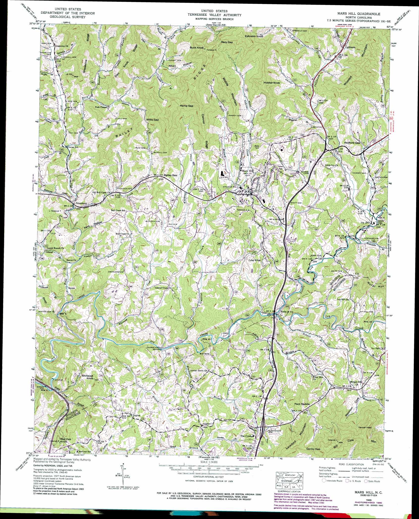
USGS Topo Quad 35082g5 - 1:24,000 scale
| Topo Map Name: | Mars Hill |
| USGS Topo Quad ID: | 35082g5 |
| Print Size: | ca. 21 1/4" wide x 27" high |
| Southeast Coordinates: | 35.75° N latitude / 82.5° W longitude |
| Map Center Coordinates: | 35.8125° N latitude / 82.5625° W longitude |
| U.S. State: | NC |
| Filename: | o35082g5.jpg |
| Download Map JPG Image: | Mars Hill topo map 1:24,000 scale |
| Map Type: | Topographic |
| Topo Series: | 7.5´ |
| Map Scale: | 1:24,000 |
| Source of Map Images: | United States Geological Survey (USGS) |
| Alternate Map Versions: |
Mars Hill NC 1936 Download PDF Buy paper map Mars Hill NC 1945, updated 1957 Download PDF Buy paper map Mars Hill NC 1945, updated 1970 Download PDF Buy paper map Mars Hill NC 1945, updated 1979 Download PDF Buy paper map Mars Hill NC 1945, updated 1990 Download PDF Buy paper map Mars Hill NC 1946, updated 1947 Download PDF Buy paper map Mars Hill NC 2010 Download PDF Buy paper map Mars Hill NC 2013 Download PDF Buy paper map Mars Hill NC 2016 Download PDF Buy paper map |
1:24,000 Topo Quads surrounding Mars Hill
Davy Crockett Lake |
Greystone |
Flag Pond |
Chestoa |
Huntdale |
Hot Springs |
White Rock |
Sams Gap |
Bald Creek |
Burnsville |
Spring Creek |
Marshall |
Mars Hill |
Barnardsville |
Mount Mitchell |
Sandymush |
Leicester |
Weaverville |
Craggy Pinnacle |
Montreat |
Canton |
Enka |
Asheville |
Oteen |
Black Mountain |
> Back to 35082e1 at 1:100,000 scale
> Back to 35082a1 at 1:250,000 scale
> Back to U.S. Topo Maps home
Mars Hill topo map: Gazetteer
Mars Hill: Bends
Bull Hole elevation 609m 1998′Mars Hill: Bridges
Palmer Ford Bridge elevation 572m 1876′Mars Hill: Dams
Ivy Dam elevation 539m 1768′Mars Hill: Gaps
Bailey Gap elevation 715m 2345′Gentry Gap elevation 795m 2608′
Hamp Gap elevation 976m 3202′
Mary Gap elevation 1009m 3310′
Pack Saddle elevation 694m 2276′
Radford Gap elevation 707m 2319′
Willis Gap elevation 791m 2595′
Mars Hill: Populated Places
Beech Glen elevation 641m 2103′California elevation 725m 2378′
Flat Creek elevation 674m 2211′
Forks of Ivy elevation 599m 1965′
Ivy elevation 633m 2076′
Jupiter elevation 663m 2175′
Long Ridge elevation 691m 2267′
Mars Hill elevation 704m 2309′
Petersburg elevation 605m 1984′
Sexton elevation 572m 1876′
Mars Hill: Ridges
Bailey Ridge elevation 1015m 3330′Connor Ridge elevation 913m 2995′
Dan Knob Ridge elevation 859m 2818′
Mars Hill: Streams
Adkins Branch elevation 590m 1935′Ammons Branch elevation 688m 2257′
Banjo Branch elevation 669m 2194′
Bearwallow Branch elevation 797m 2614′
Beetree Creek elevation 660m 2165′
Big Branch elevation 610m 2001′
Blackstock Branch elevation 573m 1879′
Bone Camp Creek elevation 606m 1988′
Bull Creek elevation 551m 1807′
California Creek elevation 638m 2093′
Cargle Branch elevation 670m 2198′
Chandler Creek elevation 733m 2404′
Cody Branch elevation 611m 2004′
Dans Branch elevation 766m 2513′
Dill Branch elevation 633m 2076′
East Fork Bull Creek elevation 615m 2017′
Eller Branch elevation 565m 1853′
Fisher Branch elevation 635m 2083′
Gabriel Creek elevation 574m 1883′
Gentry Branch elevation 616m 2020′
Gosnell Branch elevation 688m 2257′
Griffin Branch elevation 647m 2122′
Grooms Branch elevation 743m 2437′
Halewood Creek elevation 606m 1988′
Higgins Branch elevation 682m 2237′
Hobson Branch elevation 599m 1965′
Holcombe Branch elevation 631m 2070′
Hunter Branch elevation 545m 1788′
Jarvis Branch elevation 693m 2273′
Laurel Branch elevation 562m 1843′
Little Ivy Creek elevation 608m 1994′
Meadow Branch elevation 784m 2572′
Middle Fork California Creek elevation 640m 2099′
Morgan Branch elevation 633m 2076′
Nowhere Branch elevation 571m 1873′
Paint Fork elevation 637m 2089′
Sprinkle Creek elevation 716m 2349′
Sprinkler Branch elevation 652m 2139′
Sprouse Branch elevation 557m 1827′
Stanley Branch elevation 626m 2053′
Stillhouse Branch elevation 552m 1811′
Sugar Camp Branch elevation 522m 1712′
Thomas Branch elevation 628m 2060′
Walker Branch elevation 645m 2116′
West Fork Bull Creek elevation 615m 2017′
Whiteoak Creek elevation 560m 1837′
Mars Hill: Summits
Bill Cole Mountain elevation 999m 3277′Buck Knob elevation 1090m 3576′
Ephraim Knob elevation 1103m 3618′
Farmer Field elevation 785m 2575′
Hooker Knob elevation 1007m 3303′
Middle Mountain elevation 986m 3234′
Red Oak Knob elevation 690m 2263′
Whiteoak Knob elevation 687m 2253′
Wooded Mountain elevation 965m 3166′
Mars Hill: Valleys
Kent Hollow elevation 578m 1896′Stockton Cove elevation 671m 2201′
Whitt Hollow elevation 751m 2463′
Mars Hill digital topo map on disk
Buy this Mars Hill topo map showing relief, roads, GPS coordinates and other geographical features, as a high-resolution digital map file on DVD:
South Carolina, Western North Carolina & Northeastern Georgia
Buy digital topo maps: South Carolina, Western North Carolina & Northeastern Georgia