Cashiers Topo Map North Carolina
To zoom in, hover over the map of Cashiers
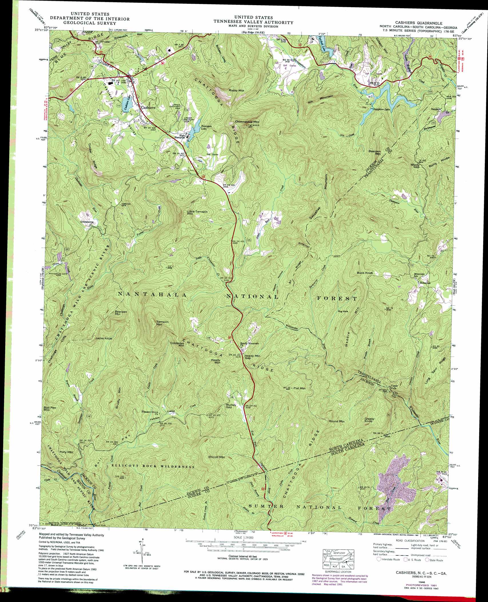
USGS Topo Quad 35083a1 - 1:24,000 scale
| Topo Map Name: | Cashiers |
| USGS Topo Quad ID: | 35083a1 |
| Print Size: | ca. 21 1/4" wide x 27" high |
| Southeast Coordinates: | 35° N latitude / 83° W longitude |
| Map Center Coordinates: | 35.0625° N latitude / 83.0625° W longitude |
| U.S. States: | NC, GA, SC |
| Filename: | o35083a1.jpg |
| Download Map JPG Image: | Cashiers topo map 1:24,000 scale |
| Map Type: | Topographic |
| Topo Series: | 7.5´ |
| Map Scale: | 1:24,000 |
| Source of Map Images: | United States Geological Survey (USGS) |
| Alternate Map Versions: |
Cashiers NC 1935 Download PDF Buy paper map Cashiers NC 1946, updated 1957 Download PDF Buy paper map Cashiers NC 1946, updated 1966 Download PDF Buy paper map Cashiers NC 1946, updated 1972 Download PDF Buy paper map Cashiers NC 1946, updated 1991 Download PDF Buy paper map Cashiers NC 1947, updated 1947 Download PDF Buy paper map Cashiers NC 1997, updated 2001 Download PDF Buy paper map Cashiers NC 2011 Download PDF Buy paper map Cashiers NC 2013 Download PDF Buy paper map Cashiers NC 2016 Download PDF Buy paper map |
| FStopo: | US Forest Service topo Cashiers is available: Download FStopo PDF Download FStopo TIF |
1:24,000 Topo Quads surrounding Cashiers
Greens Creek |
Sylva South |
Tuckasegee |
Sam Knob |
Shining Rock |
Corbin Knob |
Glenville |
Big Ridge |
Lake Toxaway |
Rosman |
Scaly Mountain |
Highlands |
Cashiers |
Reid |
Eastatoe Gap |
Rabun Bald |
Satolah |
Tamassee |
Salem |
Sunset |
Rainy Mountain |
Whetstone |
Walhalla |
Old Pickens |
Six Mile |
> Back to 35083a1 at 1:100,000 scale
> Back to 35082a1 at 1:250,000 scale
> Back to U.S. Topo Maps home
Cashiers topo map: Gazetteer
Cashiers: Cliffs
Chattooga Cliffs elevation 810m 2657′Cashiers: Dams
Cashiers Lake Dam elevation 1055m 3461′Fairfield Lake Dam elevation 972m 3188′
Hampton Lake Dam elevation 1042m 3418′
Hogback Dam elevation 960m 3149′
Holly Berry Mountain Dam elevation 828m 2716′
Intermont Dam elevation 966m 3169′
Meadow Lake Dam elevation 960m 3149′
Sapphire Lake Dam elevation 951m 3120′
Cashiers: Falls
Upper Falls elevation 757m 2483′Cashiers: Flats
Big Hole elevation 952m 3123′Cashiers: Gaps
Heady Mountain Gap elevation 1046m 3431′Mulkey Gap elevation 964m 3162′
Windy Gap elevation 1074m 3523′
Cashiers: Pillars
Ellicott Rock elevation 655m 2148′Cashiers: Populated Places
Bohaynee elevation 985m 3231′Cashiers elevation 1062m 3484′
Grimshawes elevation 862m 2828′
High Hampton elevation 1049m 3441′
Sapphire elevation 968m 3175′
Cashiers: Reservoirs
Cashiers Lake elevation 1055m 3461′Fairfield Lake elevation 962m 3156′
Fairfield Lake elevation 972m 3188′
Hampton Lake elevation 1042m 3418′
Hogback Lake elevation 960m 3149′
Holly Berry Mountain Lake elevation 828m 2716′
Intermont Lake elevation 966m 3169′
Meadow Lake elevation 960m 3149′
Sapphire Lake elevation 951m 3120′
Cashiers: Ridges
Air Ridge elevation 1091m 3579′Chattooga Ridge elevation 953m 3126′
Timber Ridge elevation 1136m 3727′
Cashiers: Streams
Bad Creek elevation 568m 1863′Bryson Branch elevation 865m 2837′
Corbin Creek elevation 626m 2053′
Dark Branch elevation 838m 2749′
Dark Branch elevation 837m 2746′
Democrat Creek elevation 914m 2998′
Fowler Creek elevation 667m 2188′
Fowler Creek elevation 823m 2700′
Glade Creek elevation 714m 2342′
Green Creek elevation 796m 2611′
Hogback Creek elevation 918m 3011′
Jacks Creek elevation 835m 2739′
Jacks Creek elevation 836m 2742′
Little Hogback Creek elevation 931m 3054′
Little Whitewater Creek elevation 982m 3221′
Mud Creek elevation 954m 3129′
Nicholson Licklog Creek elevation 825m 2706′
Nix Creek elevation 949m 3113′
Scotsman Creek elevation 712m 2335′
Silver Run Creek elevation 1005m 3297′
Slatten Branch elevation 826m 2709′
Waddle Branch elevation 822m 2696′
Cashiers: Summits
Bearpen Mountain elevation 1149m 3769′Bearpen Mountain elevation 1207m 3959′
Brushy Mountain elevation 1061m 3480′
Buck Knob elevation 1210m 3969′
Bull Pen Mountain elevation 1017m 3336′
Chimneytop Mountain elevation 1396m 4580′
Coldsides Mountain elevation 1219m 3999′
Ellicott Mountain elevation 1137m 3730′
Flat Mountain elevation 1196m 3923′
Grassy Knob elevation 1040m 3412′
Heady Mountain elevation 1151m 3776′
Jacks Knob elevation 1043m 3421′
Little Terrapin Mountain elevation 1230m 4035′
Nix Mountain elevation 1190m 3904′
Polly Mountain elevation 945m 3100′
Rainy Knobs elevation 1160m 3805′
Rocky Mountain elevation 1321m 4333′
Round Mountain elevation 1125m 3690′
Sassafras Mountain elevation 1335m 4379′
Terrapin Mountain elevation 1362m 4468′
Waddle Mountain elevation 1146m 3759′
Cashiers: Trails
Foothills Trail elevation 874m 2867′Cashiers: Valleys
Cashiers Valley elevation 1046m 3431′Happy Hollow elevation 964m 3162′
Cashiers digital topo map on disk
Buy this Cashiers topo map showing relief, roads, GPS coordinates and other geographical features, as a high-resolution digital map file on DVD:
South Carolina, Western North Carolina & Northeastern Georgia
Buy digital topo maps: South Carolina, Western North Carolina & Northeastern Georgia