Tuckasegee Topo Map North Carolina
To zoom in, hover over the map of Tuckasegee
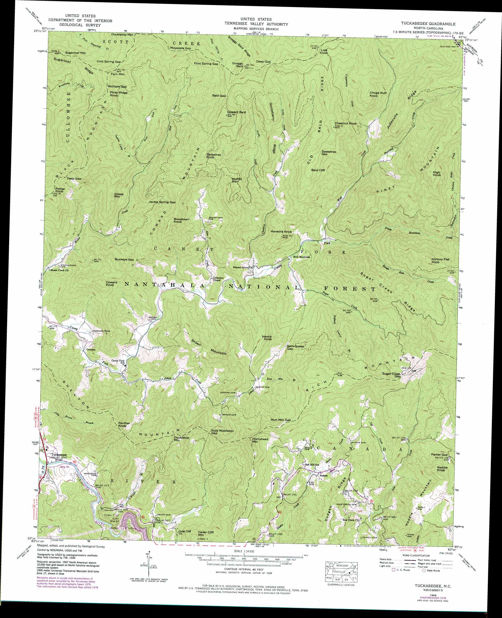
USGS Topo Quad 35083c1 - 1:24,000 scale
| Topo Map Name: | Tuckasegee |
| USGS Topo Quad ID: | 35083c1 |
| Print Size: | ca. 21 1/4" wide x 27" high |
| Southeast Coordinates: | 35.25° N latitude / 83° W longitude |
| Map Center Coordinates: | 35.3125° N latitude / 83.0625° W longitude |
| U.S. State: | NC |
| Filename: | o35083c1.jpg |
| Download Map JPG Image: | Tuckasegee topo map 1:24,000 scale |
| Map Type: | Topographic |
| Topo Series: | 7.5´ |
| Map Scale: | 1:24,000 |
| Source of Map Images: | United States Geological Survey (USGS) |
| Alternate Map Versions: |
Tuckaseigee NC 1935 Download PDF Buy paper map Tuckasegee NC 1946, updated 1957 Download PDF Buy paper map Tuckasegee NC 1946, updated 1966 Download PDF Buy paper map Tuckasegee NC 1946, updated 1971 Download PDF Buy paper map Tuckasegee NC 1946, updated 1978 Download PDF Buy paper map Tuckasegee NC 1946, updated 1989 Download PDF Buy paper map Tuckasegee NC 1947, updated 1947 Download PDF Buy paper map Tuckasegee NC 1947, updated 1947 Download PDF Buy paper map Tuckasegee NC 1997, updated 2001 Download PDF Buy paper map Tuckasegee NC 2011 Download PDF Buy paper map Tuckasegee NC 2013 Download PDF Buy paper map Tuckasegee NC 2016 Download PDF Buy paper map |
| FStopo: | US Forest Service topo Tuckasegee is available: Download FStopo PDF Download FStopo TIF |
1:24,000 Topo Quads surrounding Tuckasegee
Smokemont |
Bunches Bald |
Dellwood |
Clyde |
Canton |
Whittier |
Sylva North |
Hazelwood |
Waynesville |
Cruso |
Greens Creek |
Sylva South |
Tuckasegee |
Sam Knob |
Shining Rock |
Corbin Knob |
Glenville |
Big Ridge |
Lake Toxaway |
Rosman |
Scaly Mountain |
Highlands |
Cashiers |
Reid |
Eastatoe Gap |
> Back to 35083a1 at 1:100,000 scale
> Back to 35082a1 at 1:250,000 scale
> Back to U.S. Topo Maps home
Tuckasegee topo map: Gazetteer
Tuckasegee: Cliffs
Bald Cliff elevation 1428m 4685′Tuckasegee: Dams
Cedar Cliff Dam elevation 709m 2326′Tuckasegee: Gaps
Bald Gap elevation 1480m 4855′Buckeye Gap elevation 1023m 3356′
Cold Spring Gap elevation 1446m 4744′
Deep Gap elevation 1149m 3769′
Deep Gap elevation 1489m 4885′
Flint Spring Gap elevation 1437m 4714′
Jackie Spring Gap elevation 1229m 4032′
Mayapple Gap elevation 1382m 4534′
Parker Gap elevation 1235m 4051′
Polly Middleton Gap elevation 1039m 3408′
Rich Mountain Gap elevation 1315m 4314′
Sam Queen Gap elevation 1122m 3681′
Sassafras Gap elevation 1406m 4612′
Sugar Creek Gap elevation 1394m 4573′
Wolfpen Gap elevation 1407m 4616′
Tuckasegee: Parks
Roy Taylor Forest elevation 1397m 4583′Tuckasegee: Pillars
Judaculla Rock elevation 688m 2257′Tuckasegee: Populated Places
Argura elevation 1001m 3284′Cowarts elevation 686m 2250′
Rich Mountain elevation 814m 2670′
Tuckasegee elevation 660m 2165′
Tuckasegee: Reservoirs
Cedar Cliff Lake elevation 706m 2316′Tuckasegee: Ridges
Dodgen Ridge elevation 1198m 3930′Gooseberry Ridge elevation 1315m 4314′
Judaculla Ridge elevation 1383m 4537′
Old Bald Ridge elevation 1551m 5088′
Sugar Creek Ridge elevation 1330m 4363′
Sugarloaf Ridge elevation 1291m 4235′
Tuckasegee: Springs
Cedar Valley Spring elevation 1071m 3513′Tuckasegee: Streams
Abbs Creek elevation 736m 2414′Bearwallow Creek elevation 1099m 3605′
Beechflat Creek elevation 983m 3225′
Birch Ridge Creek elevation 1170m 3838′
Canoe Creek elevation 658m 2158′
Cedar Valley Creek elevation 718m 2355′
Chastine Creek elevation 777m 2549′
Chestnut Ridge Creek elevation 1222m 4009′
Coppermine Creek elevation 1096m 3595′
Craig Creek elevation 1086m 3562′
Dryland Laurel Branch elevation 944m 3097′
East Fork Moses Creek elevation 948m 3110′
Frady Creek elevation 1004m 3293′
Indian Camp Branch elevation 1034m 3392′
Jeff Creek elevation 1082m 3549′
Johns Creek elevation 697m 2286′
Mull Creek elevation 829m 2719′
Piney Mountain Creek elevation 893m 2929′
Rich Mountain Branch elevation 994m 3261′
Rough Butt Creek elevation 893m 2929′
Sugar Creek elevation 797m 2614′
West Fork Moses Creek elevation 948m 3110′
West Fork Tuckasegee River elevation 651m 2135′
Woods Branch elevation 659m 2162′
Tuckasegee: Summits
Black Mountain elevation 1428m 4685′Brasstown Knob elevation 1294m 4245′
Brown Mountain elevation 1114m 3654′
Cedar Cliff Mountain elevation 1031m 3382′
Cedar Valley Knob elevation 1084m 3556′
Chestnut Knob elevation 1483m 4865′
Choga Butt Knob elevation 1462m 4796′
Coward Bald elevation 1581m 5187′
Coward Knob elevation 1143m 3750′
Coward Mountain elevation 1241m 4071′
Doubletop Mountain elevation 1241m 4071′
Fern Mountain elevation 1471m 4826′
Hawkins Knob elevation 1139m 3736′
Hench Knob elevation 1220m 4002′
Hickory Flat Knob elevation 1378m 4520′
High Knob elevation 1580m 5183′
Hornyhead Mountain elevation 1316m 4317′
Lost Knob elevation 1662m 5452′
Moffitt Mountain elevation 1351m 4432′
Neddie Knob elevation 1372m 4501′
Panther Knob elevation 1156m 3792′
Parker Knob elevation 1273m 4176′
Piney Mountain elevation 1641m 5383′
Piney Ridge Knob elevation 1423m 4668′
Sassafras Knob elevation 1414m 4639′
Sheep Mountain elevation 1109m 3638′
Shelton Mountain elevation 1236m 4055′
Snaggy Bald elevation 1653m 5423′
Sugarloaf Mountain elevation 1388m 4553′
Tuckasegee digital topo map on disk
Buy this Tuckasegee topo map showing relief, roads, GPS coordinates and other geographical features, as a high-resolution digital map file on DVD:
South Carolina, Western North Carolina & Northeastern Georgia
Buy digital topo maps: South Carolina, Western North Carolina & Northeastern Georgia