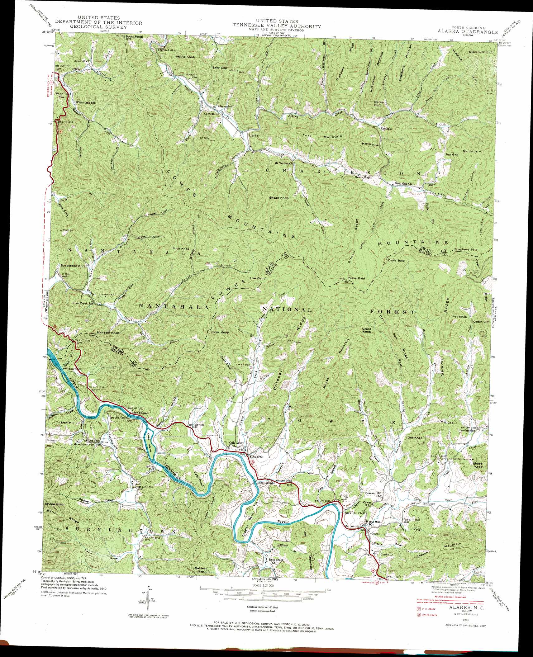
Alarka Topo Map North Carolina
To zoom in, hover over the map of Alarka
USGS Topo Quad 35083c4 - 1:24,000 scale
| Topo Map Name: | Alarka |
| USGS Topo Quad ID: | 35083c4 |
| Print Size: | ca. 21 1/4" wide x 27" high |
| Southeast Coordinates: | 35.25° N latitude / 83.375° W longitude |
| Map Center Coordinates: | 35.3125° N latitude / 83.4375° W longitude |
| U.S. State: | NC |
| Filename: | o35083c4.jpg |
| Download Map JPG Image: | Alarka topo map 1:24,000 scale |
| Map Type: | Topographic |
| Topo Series: | 7.5´ |
| Map Scale: | 1:24,000 |
| Source of Map Images: | United States Geological Survey (USGS) |
| Alternate Map Versions: |
Alarka NC 1936 Download PDF Buy paper map Alarka NC 1940, updated 1957 Download PDF Buy paper map Alarka NC 1940, updated 1965 Download PDF Buy paper map Alarka NC 1940, updated 1973 Download PDF Buy paper map Alarka NC 1940, updated 1973 Download PDF Buy paper map Alarka NC 1941 Download PDF Buy paper map Alarka NC 2011 Download PDF Buy paper map Alarka NC 2013 Download PDF Buy paper map Alarka NC 2016 Download PDF Buy paper map |
| FStopo: | US Forest Service topo Alarka is available: Download FStopo PDF Download FStopo TIF |
1:24,000 Topo Quads surrounding Alarka
Thunderhead Mountain |
Silers Bald |
Clingmans Dome |
Smokemont |
Bunches Bald |
Tuskeegee |
Noland Creek |
Bryson City |
Whittier |
Sylva North |
Hewitt |
Wesser |
Alarka |
Greens Creek |
Sylva South |
Topton |
Wayah Bald |
Franklin |
Corbin Knob |
Glenville |
Shooting Creek |
Rainbow Springs |
Prentiss |
Scaly Mountain |
Highlands |
> Back to 35083a1 at 1:100,000 scale
> Back to 35082a1 at 1:250,000 scale
> Back to U.S. Topo Maps home
Alarka topo map: Gazetteer
Alarka: Bends
Coggins Bend elevation 615m 2017′Raby Bend elevation 626m 2053′
Alarka: Bridges
Lost Bridge elevation 576m 1889′McCoy Bridge elevation 588m 1929′
Alarka: Cliffs
Cedar Cliff elevation 952m 3123′Alarka: Dams
Pyle Dam elevation 601m 1971′Alarka: Gaps
Deep Gap elevation 909m 2982′Low Gap elevation 1013m 3323′
Mill Gap elevation 714m 2342′
Saldeer Gap elevation 742m 2434′
Sally Gap elevation 779m 2555′
Una Gap elevation 1063m 3487′
Alarka: Islands
Dean Island elevation 579m 1899′Alarka: Lakes
McCoys Fishing Lake elevation 631m 2070′Alarka: Mines
Bonanza Mine elevation 647m 2122′Caler Creek Ruby Mine elevation 679m 2227′
Dale and Demkos Mine elevation 634m 2080′
Gibsons Ruby Mine elevation 627m 2057′
Jacobs Mine elevation 625m 2050′
Jones Ruby Mine elevation 658m 2158′
Sheffield Mine elevation 636m 2086′
Yukon Mine elevation 640m 2099′
Alarka: Populated Places
Alarka elevation 651m 2135′Cowee elevation 614m 2014′
Leatherman elevation 668m 2191′
Oak Grove elevation 606m 1988′
Shallow Ford elevation 567m 1860′
Stiles elevation 598m 1961′
Unahala elevation 782m 2565′
Alarka: Post Offices
Etna Post Office elevation 591m 1938′Wests Mill Post Office elevation 602m 1975′
Alarka: Reservoirs
Pyle Lake elevation 601m 1971′Alarka: Ridges
Buckhorn Ridge elevation 1246m 4087′Cedar Cliff Ridge elevation 885m 2903′
Devil Den Ridge elevation 1039m 3408′
Gibson Ridge elevation 1256m 4120′
Hickorynut Mountain elevation 1215m 3986′
Kelly Ridge elevation 886m 2906′
Polecat Ridge elevation 872m 2860′
Sawmill Ridge elevation 1022m 3353′
Alarka: Streams
Battle Creek elevation 627m 2057′Bearmeat Branch elevation 967m 3172′
Bird Branch elevation 572m 1876′
Bowers Creek elevation 648m 2125′
Bradley Creek elevation 587m 1925′
Burningtown Creek elevation 573m 1879′
Caler Cove Branch elevation 587m 1925′
Caler Fork elevation 611m 2004′
Carter Branch elevation 592m 1942′
Cold Spring Branch elevation 993m 3257′
Cowee Creek elevation 592m 1942′
Cullasaja Branch elevation 664m 2178′
Davis Creek elevation 558m 1830′
Dolph Branch elevation 630m 2066′
Falls Branch elevation 912m 2992′
First Hurricane Branch elevation 715m 2345′
Gibby Branch elevation 645m 2116′
Hickorynut Branch elevation 794m 2604′
Hurricane Branch elevation 650m 2132′
Jones Creek elevation 705m 2312′
Lakey Creek elevation 586m 1922′
Little Laurel Creek elevation 871m 2857′
Long Branch elevation 687m 2253′
Long Branch elevation 584m 1916′
Long Creek elevation 830m 2723′
Marr Branch elevation 604m 1981′
Mason Branch elevation 898m 2946′
Matlock Creek elevation 607m 1991′
Pigeon Creek elevation 669m 2194′
Piney Wood Creek elevation 847m 2778′
Polecat Branch elevation 677m 2221′
Potts Branch elevation 591m 1938′
Queen Branch elevation 577m 1893′
Rickman Creek elevation 628m 2060′
Rose Creek elevation 588m 1929′
Second Hurricane Branch elevation 738m 2421′
Shepherd Creek elevation 638m 2093′
Simon Branch elevation 567m 1860′
Stillhouse Branch elevation 593m 1945′
Tellico Creek elevation 571m 1873′
Thomason Branch elevation 602m 1975′
Una Creek elevation 759m 2490′
Upper Long Creek elevation 991m 3251′
Wests Branch elevation 653m 2142′
Wildcat Branch elevation 758m 2486′
Alarka: Summits
Arch Hill elevation 694m 2276′Barker Butt elevation 1080m 3543′
Blackrock Knob elevation 1285m 4215′
Caler Knob elevation 1088m 3569′
Davis Bald elevation 1349m 4425′
Fork Mountain elevation 1012m 3320′
Grant Knob elevation 1165m 3822′
Hall Mountain elevation 731m 2398′
Mica Knob elevation 1060m 3477′
Mouse Mountain elevation 1047m 3435′
Owl Knob elevation 819m 2687′
Pat Knob elevation 1048m 3438′
Peaks Bald elevation 1393m 4570′
Phillip Knob elevation 877m 2877′
Pinnacle Knob elevation 905m 2969′
Scott Knob elevation 902m 2959′
Shepherd Bald elevation 1438m 4717′
Shope Knob elevation 1107m 3631′
Soapstone Knob elevation 782m 2565′
Alarka: Valleys
Billy Cove elevation 645m 2116′Bryson Cove elevation 605m 1984′
Caler Cove elevation 661m 2168′
Flower Cove elevation 807m 2647′
Grape Cove elevation 725m 2378′
Hickory Cove elevation 624m 2047′
Kelly Cove elevation 602m 1975′
Lynn Cove elevation 1004m 3293′
Martin Cove elevation 804m 2637′
Shope Cove elevation 592m 1942′
Wests Cove elevation 596m 1955′
Alarka digital topo map on disk
Buy this Alarka topo map showing relief, roads, GPS coordinates and other geographical features, as a high-resolution digital map file on DVD:
South Carolina, Western North Carolina & Northeastern Georgia
Buy digital topo maps: South Carolina, Western North Carolina & Northeastern Georgia