Bryson City Topo Map North Carolina
To zoom in, hover over the map of Bryson City
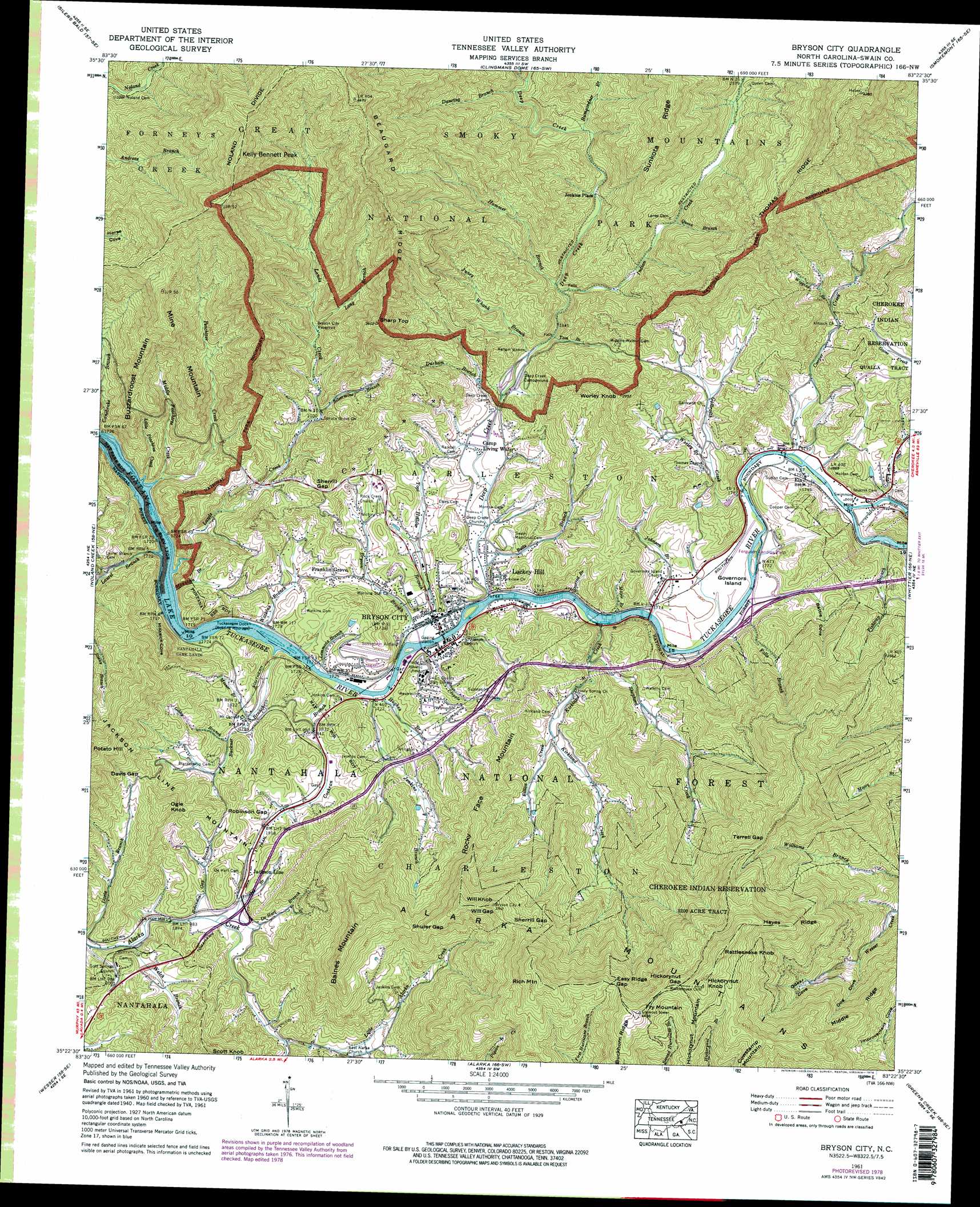
USGS Topo Quad 35083d4 - 1:24,000 scale
| Topo Map Name: | Bryson City |
| USGS Topo Quad ID: | 35083d4 |
| Print Size: | ca. 21 1/4" wide x 27" high |
| Southeast Coordinates: | 35.375° N latitude / 83.375° W longitude |
| Map Center Coordinates: | 35.4375° N latitude / 83.4375° W longitude |
| U.S. State: | NC |
| Filename: | o35083d4.jpg |
| Download Map JPG Image: | Bryson City topo map 1:24,000 scale |
| Map Type: | Topographic |
| Topo Series: | 7.5´ |
| Map Scale: | 1:24,000 |
| Source of Map Images: | United States Geological Survey (USGS) |
| Alternate Map Versions: |
Bryson NC 1936 Download PDF Buy paper map Bryson NC 1940, updated 1957 Download PDF Buy paper map Bryson NC 1941 Download PDF Buy paper map Bryson NC 1941 Download PDF Buy paper map Bryson City NC 1961, updated 1964 Download PDF Buy paper map Bryson City NC 1961, updated 1971 Download PDF Buy paper map Bryson City NC 1961, updated 1978 Download PDF Buy paper map Bryson City NC 2011 Download PDF Buy paper map Bryson City NC 2013 Download PDF Buy paper map Bryson City NC 2016 Download PDF Buy paper map |
| FStopo: | US Forest Service topo Bryson City is available: Download FStopo PDF Download FStopo TIF |
1:24,000 Topo Quads surrounding Bryson City
Wear Cove |
Gatlinburg |
Mount Le Conte |
Mount Guyot |
Luftee Knob |
Thunderhead Mountain |
Silers Bald |
Clingmans Dome |
Smokemont |
Bunches Bald |
Tuskeegee |
Noland Creek |
Bryson City |
Whittier |
Sylva North |
Hewitt |
Wesser |
Alarka |
Greens Creek |
Sylva South |
Topton |
Wayah Bald |
Franklin |
Corbin Knob |
Glenville |
> Back to 35083a1 at 1:100,000 scale
> Back to 35082a1 at 1:250,000 scale
> Back to U.S. Topo Maps home
Bryson City topo map: Gazetteer
Bryson City: Airports
Ferguson Field Municipal elevation 543m 1781′Sossamon Field elevation 586m 1922′
Bryson City: Dams
Bryson City Dam elevation 716m 2349′Bryson City: Gaps
Davis Gap elevation 705m 2312′Easy Ridge Gap elevation 1238m 4061′
Hickorynut Gap elevation 1348m 4422′
Robinson Gap elevation 635m 2083′
Sherrill Gap elevation 1088m 3569′
Sherrill Gap elevation 663m 2175′
Shuler Gap elevation 909m 2982′
Terrell Gap elevation 1049m 3441′
Will Gap elevation 1055m 3461′
Bryson City: Islands
Governors Island elevation 537m 1761′Bryson City: Populated Places
Bryson City elevation 528m 1732′De Hart Mill elevation 569m 1866′
Ela elevation 547m 1794′
Franklin Grove elevation 568m 1863′
Jackson Line elevation 600m 1968′
Jenkins Place elevation 596m 1955′
Lackey Hill elevation 553m 1814′
Bryson City: Reservoirs
Bryson City Reservoir elevation 716m 2349′Bryson City: Ridges
Alarka Mountains elevation 1231m 4038′Beaugard Ridge elevation 1174m 3851′
Hayes Ridge elevation 1238m 4061′
Bryson City: Streams
Betts Branch elevation 529m 1735′Bryson Branch elevation 526m 1725′
Buckner Branch elevation 521m 1709′
Bumgardner Branch elevation 614m 2014′
Cochran Branch elevation 520m 1706′
Cooper Creek elevation 542m 1778′
Cripple Creek elevation 529m 1735′
Dancing Branch elevation 645m 2116′
De Hart Branch elevation 577m 1893′
Deep Creek elevation 528m 1732′
Durham Branch elevation 549m 1801′
Falls Branch elevation 540m 1771′
Fishtrap Branch elevation 549m 1801′
Frisbee Branch elevation 572m 1876′
Galbraith Creek elevation 539m 1768′
Gibby Branch elevation 558m 1830′
Hammer Branch elevation 580m 1902′
Hughes Branch elevation 523m 1715′
Indian Creek elevation 568m 1863′
Jenkins Branch elevation 524m 1719′
Johnson Branch elevation 534m 1751′
Juney Whank Branch elevation 553m 1814′
Kirkland Creek elevation 533m 1748′
Lands Creek elevation 514m 1686′
Laurel Branch elevation 512m 1679′
Lemmons Branch elevation 520m 1706′
Little Alarka Creek elevation 601m 1971′
Little Peachtree Creek elevation 513m 1683′
Long Branch elevation 714m 2342′
Maple Branch elevation 532m 1745′
Messer Branch elevation 542m 1778′
Middle Peachtree Creek elevation 531m 1742′
Mountain Branch elevation 518m 1699′
Oconaluftee River elevation 544m 1784′
Peachtree Creek elevation 513m 1683′
Queen Branch elevation 640m 2099′
Robinson Branch elevation 568m 1863′
Scarred Branch elevation 543m 1781′
Shepherd Creek elevation 562m 1843′
Silvermine Branch elevation 646m 2119′
Sitton Creek elevation 607m 1991′
Tom Branch elevation 559m 1833′
Toot Hollow Branch elevation 525m 1722′
Watkins Branch elevation 518m 1699′
Welch Branch elevation 556m 1824′
Wiggins Branch elevation 604m 1981′
Worley Branch elevation 604m 1981′
Bryson City: Summits
Baines Mountain elevation 1071m 3513′Buzzardroost Mountain elevation 1012m 3320′
Cowstamp Mountain elevation 1307m 4288′
Fry Mountain elevation 1371m 4498′
Hickorynut Knob elevation 1416m 4645′
Kelly Bennett Peak elevation 1336m 4383′
Mine Mountain elevation 1033m 3389′
Ogle Knob elevation 799m 2621′
Rattlesnake Knob elevation 1409m 4622′
Rich Mountain elevation 1324m 4343′
Rocky Face Mountain elevation 1082m 3549′
Sharp Top elevation 1031m 3382′
Will Knob elevation 1122m 3681′
Worley Knob elevation 824m 2703′
Bryson City: Valleys
Battle Cove elevation 538m 1765′Dog Cove elevation 813m 2667′
Milksick Cove elevation 521m 1709′
Odear Cove elevation 932m 3057′
Bryson City digital topo map on disk
Buy this Bryson City topo map showing relief, roads, GPS coordinates and other geographical features, as a high-resolution digital map file on DVD:
South Carolina, Western North Carolina & Northeastern Georgia
Buy digital topo maps: South Carolina, Western North Carolina & Northeastern Georgia