Fontana Dam Topo Map North Carolina
To zoom in, hover over the map of Fontana Dam
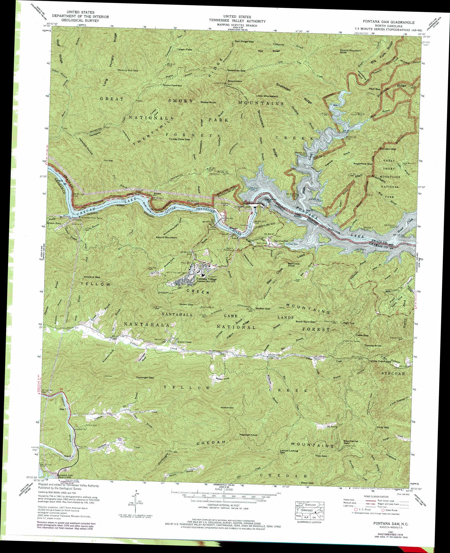
USGS Topo Quad 35083d7 - 1:24,000 scale
| Topo Map Name: | Fontana Dam |
| USGS Topo Quad ID: | 35083d7 |
| Print Size: | ca. 21 1/4" wide x 27" high |
| Southeast Coordinates: | 35.375° N latitude / 83.75° W longitude |
| Map Center Coordinates: | 35.4375° N latitude / 83.8125° W longitude |
| U.S. State: | NC |
| Filename: | o35083d7.jpg |
| Download Map JPG Image: | Fontana Dam topo map 1:24,000 scale |
| Map Type: | Topographic |
| Topo Series: | 7.5´ |
| Map Scale: | 1:24,000 |
| Source of Map Images: | United States Geological Survey (USGS) |
| Alternate Map Versions: |
Fontana NC 1935 Download PDF Buy paper map Fontana NC 1940, updated 1956 Download PDF Buy paper map Fontana NC 1940, updated 1956 Download PDF Buy paper map Fontana NC 1941 Download PDF Buy paper map Fontana Dam NC 1961, updated 1964 Download PDF Buy paper map Fontana Dam NC 1961, updated 1970 Download PDF Buy paper map Fontana Dam NC 1961, updated 1978 Download PDF Buy paper map Fontana Dam NC 1961, updated 1978 Download PDF Buy paper map Fontana Dam NC 1976, updated 1978 Download PDF Buy paper map Fontana Dam NC 2000, updated 2001 Download PDF Buy paper map Fontana Dam NC 2011 Download PDF Buy paper map Fontana Dam NC 2013 Download PDF Buy paper map Fontana Dam NC 2016 Download PDF Buy paper map |
| FStopo: | US Forest Service topo Fontana Dam is available: Download FStopo PDF Download FStopo TIF |
1:24,000 Topo Quads surrounding Fontana Dam
Binfield |
Blockhouse |
Kinzel Springs |
Wear Cove |
Gatlinburg |
Tallassee |
Calderwood |
Cades Cove |
Thunderhead Mountain |
Silers Bald |
Whiteoak Flats |
Tapoco |
Fontana Dam |
Tuskeegee |
Noland Creek |
Big Junction |
Santeetlah Creek |
Robbinsville |
Hewitt |
Wesser |
Mcdaniel Bald |
Marble |
Andrews |
Topton |
Wayah Bald |
> Back to 35083a1 at 1:100,000 scale
> Back to 35082a1 at 1:250,000 scale
> Back to U.S. Topo Maps home
Fontana Dam topo map: Gazetteer
Fontana Dam: Basins
Foster Cove elevation 751m 2463′Turkey Cove elevation 762m 2500′
Upper Flats elevation 785m 2575′
Fontana Dam: Bends
Horseshoe Bend elevation 614m 2014′Fontana Dam: Dams
Fontana Dam elevation 468m 1535′Fontana Dam elevation 507m 1663′
Fontana Dam: Gaps
Augerhole Gap elevation 718m 2355′Bearpen Gap elevation 697m 2286′
Black Gum Gap elevation 1044m 3425′
Cable Gap elevation 940m 3083′
Carringer Gap elevation 847m 2778′
Cody Gap elevation 1069m 3507′
Flint Gap elevation 686m 2250′
Fox Gap elevation 758m 2486′
Green Gap elevation 896m 2939′
Haw Gap elevation 1269m 4163′
Hickory Nut Gap elevation 885m 2903′
Kirkland Gap elevation 842m 2762′
Locust Licklog Gap elevation 1198m 3930′
Proctor Field Gap elevation 722m 2368′
Red Ridge Gap elevation 1111m 3645′
Sassafras Gap elevation 1107m 3631′
Turkey Cove Gap elevation 877m 2877′
Walker Gap elevation 1051m 3448′
Wildcat Gap elevation 1124m 3687′
Yellow Creek Gap elevation 886m 2906′
Fontana Dam: Mines
Fontana Copper Mine elevation 578m 1896′Fontana Dam: Populated Places
Fairfax elevation 411m 1348′Fontana Village elevation 555m 1820′
Rymers Ferry elevation 434m 1423′
Yellow Creek elevation 594m 1948′
Fontana Dam: Reservoirs
Fontana Lake elevation 507m 1663′Fontana Dam: Ridges
Bee Cove Lead elevation 838m 2749′Big Fork Ridge elevation 679m 2227′
Canepatch Ridge elevation 780m 2559′
Cheoah Mountains elevation 1277m 4189′
Higlon Ridge elevation 891m 2923′
Hogback elevation 1063m 3487′
Long Hungry Ridge elevation 1143m 3750′
Old Roughy elevation 964m 3162′
Red Ridge elevation 878m 2880′
Shuckstack Ridge elevation 791m 2595′
Snakeden Ridge elevation 922m 3024′
Twentymile Ridge elevation 1129m 3704′
Wolf Ridge elevation 993m 3257′
Yellow Creek Mountains elevation 948m 3110′
Fontana Dam: Springs
Big Spring elevation 1079m 3540′Fontana Dam: Streams
Augerhole Branch elevation 511m 1676′Barn Branch elevation 548m 1797′
Basin Branch elevation 846m 2775′
Bee Creek elevation 639m 2096′
Big Branch elevation 649m 2129′
Birchfield Branch elevation 511m 1676′
Blaze Branch elevation 507m 1663′
Cochran Creek elevation 515m 1689′
Cody Branch elevation 704m 2309′
Coldspring Branch elevation 611m 2004′
Colvin Branch elevation 567m 1860′
Dalton Branch elevation 563m 1847′
Deaver Branch elevation 392m 1286′
Dee Branch elevation 563m 1847′
Dummy Branch elevation 643m 2109′
Eagle Creek elevation 508m 1666′
Ecoah Branch elevation 511m 1676′
Ekaneetlee Creek elevation 572m 1876′
Farley Branch elevation 388m 1272′
Fax Creek elevation 400m 1312′
Fox Branch elevation 388m 1272′
Garrison Branch elevation 604m 1981′
Gladdens Creek elevation 523m 1715′
Gold Branch elevation 463m 1519′
Green Branch elevation 752m 2467′
Hazel Creek elevation 508m 1666′
Jack Shute Branch elevation 393m 1289′
Johnny Branch elevation 507m 1663′
Lewellyn Branch elevation 393m 1289′
Lost Cove Creek elevation 521m 1709′
Matt Branch elevation 509m 1669′
Moore Springs Branch elevation 440m 1443′
Myers Branch elevation 507m 1663′
Orr Branch elevation 559m 1833′
Panel Branch elevation 390m 1279′
Payne Branch elevation 507m 1663′
Peterson Branch elevation 552m 1811′
Pinnacle Creek elevation 544m 1784′
Proctor Branch elevation 671m 2201′
Rattlesnake Branch elevation 507m 1663′
Rickman Branch elevation 553m 1814′
Shuler Branch elevation 557m 1827′
Soapstone Branch elevation 571m 1873′
Sweet Branch elevation 390m 1279′
Turpin Branch elevation 558m 1830′
Wagontree Branch elevation 570m 1870′
Walker Branch elevation 396m 1299′
Welch Cove Branch elevation 388m 1272′
Williams Branch elevation 687m 2253′
Fontana Dam: Summits
Bee Cove Knob elevation 790m 2591′Hazanet Knob elevation 1241m 4071′
High Top elevation 1148m 3766′
Little Shuckstack elevation 1158m 3799′
Matt Mountain elevation 832m 2729′
Round Mountain elevation 745m 2444′
Round Mountain Knob elevation 907m 2975′
Sheep Knob elevation 1162m 3812′
Shuckstack elevation 1203m 3946′
Tommy Knob elevation 1054m 3458′
Wauchecha Bald elevation 1330m 4363′
Fontana Dam: Valleys
Anderson Cove elevation 567m 1860′Bee Cove elevation 508m 1666′
Brooks Cove elevation 501m 1643′
Carringer Cove elevation 572m 1876′
Hamilton Hollow elevation 481m 1578′
Johns Cove elevation 573m 1879′
Lewellyn Cove elevation 392m 1286′
Poplar Cove elevation 507m 1663′
Round Mountain Cove elevation 389m 1276′
Fontana Dam digital topo map on disk
Buy this Fontana Dam topo map showing relief, roads, GPS coordinates and other geographical features, as a high-resolution digital map file on DVD:
South Carolina, Western North Carolina & Northeastern Georgia
Buy digital topo maps: South Carolina, Western North Carolina & Northeastern Georgia