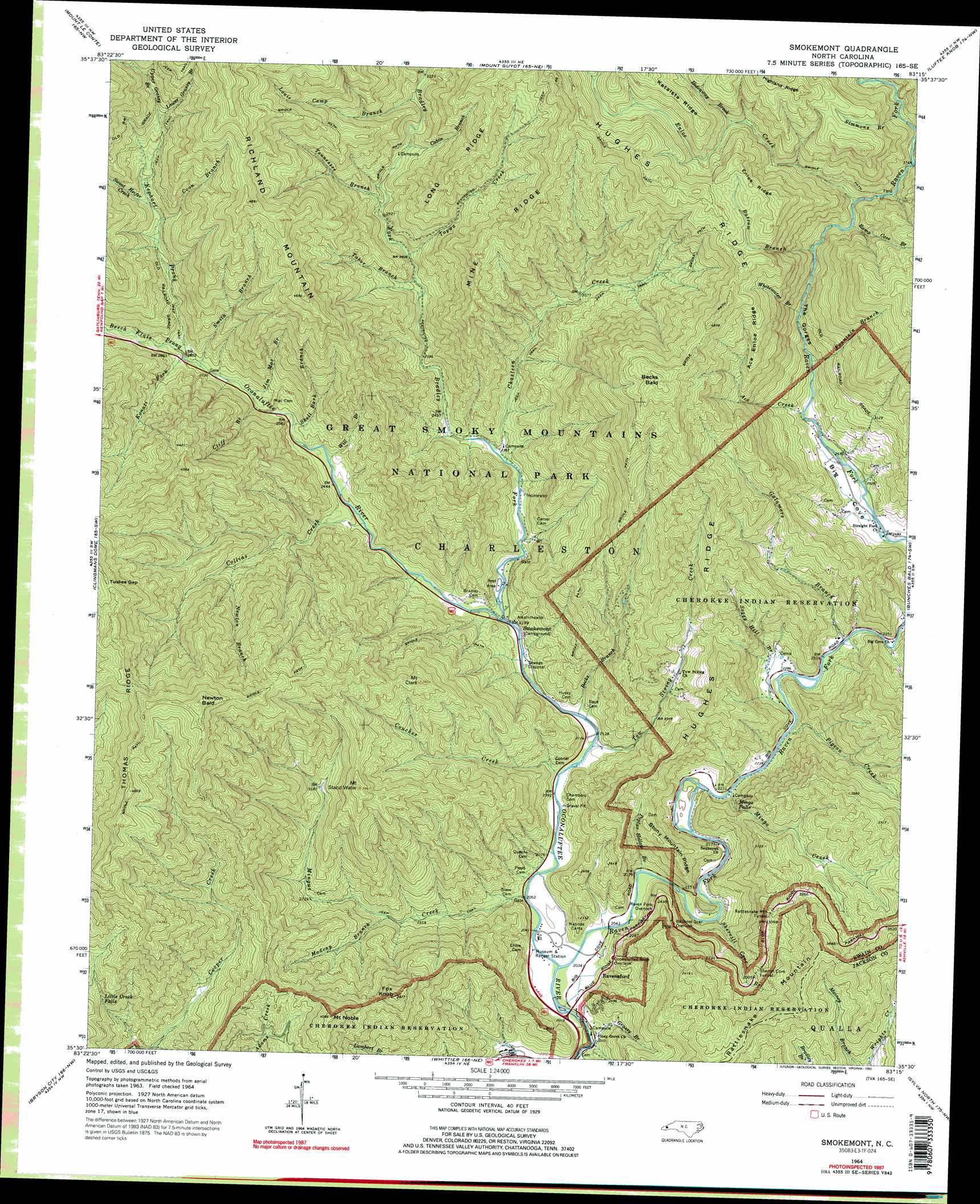
Smokemont Topo Map North Carolina
To zoom in, hover over the map of Smokemont
USGS Topo Quad 35083e3 - 1:24,000 scale
| Topo Map Name: | Smokemont |
| USGS Topo Quad ID: | 35083e3 |
| Print Size: | ca. 21 1/4" wide x 27" high |
| Southeast Coordinates: | 35.5° N latitude / 83.25° W longitude |
| Map Center Coordinates: | 35.5625° N latitude / 83.3125° W longitude |
| U.S. State: | NC |
| Filename: | o35083e3.jpg |
| Download Map JPG Image: | Smokemont topo map 1:24,000 scale |
| Map Type: | Topographic |
| Topo Series: | 7.5´ |
| Map Scale: | 1:24,000 |
| Source of Map Images: | United States Geological Survey (USGS) |
| Alternate Map Versions: |
Ravensford NC 1936 Download PDF Buy paper map Smokemont NC 1964, updated 1966 Download PDF Buy paper map Smokemont NC 1964, updated 1973 Download PDF Buy paper map Smokemont NC 1964, updated 1992 Download PDF Buy paper map Smokemont NC 1964, updated 1992 Download PDF Buy paper map Smokemont NC 2000, updated 2001 Download PDF Buy paper map Smokemont NC 2010 Download PDF Buy paper map Smokemont NC 2013 Download PDF Buy paper map Smokemont NC 2016 Download PDF Buy paper map |
1:24,000 Topo Quads surrounding Smokemont
Pigeon Forge |
Richardson Cove |
Jones Cove |
Hartford |
Waterville |
Gatlinburg |
Mount Le Conte |
Mount Guyot |
Luftee Knob |
Cove Creek Gap |
Silers Bald |
Clingmans Dome |
Smokemont |
Bunches Bald |
Dellwood |
Noland Creek |
Bryson City |
Whittier |
Sylva North |
Hazelwood |
Wesser |
Alarka |
Greens Creek |
Sylva South |
Tuckasegee |
> Back to 35083e1 at 1:100,000 scale
> Back to 35082a1 at 1:250,000 scale
> Back to U.S. Topo Maps home
Smokemont topo map: Gazetteer
Smokemont: Falls
Little Creek Falls elevation 964m 3162′Mingo Falls elevation 793m 2601′
Smokemont: Gaps
Tuskee Gap elevation 1384m 4540′Smokemont: Populated Places
Ravensford elevation 663m 2175′Smokemont: Ridges
Ace Enloe Ridge elevation 1272m 4173′Enloe Ridge elevation 1452m 4763′
Hughes Ridge elevation 1520m 4986′
Long Ridge elevation 1265m 4150′
Mine Ridge elevation 1242m 4074′
Stony Mountain Ridge elevation 848m 2782′
Thomas Ridge elevation 1451m 4760′
Smokemont: Streams
Ace Creek elevation 799m 2621′Batsaw Branch elevation 1020m 3346′
Bearwallow Branch elevation 990m 3248′
Becks Branch elevation 652m 2139′
Beech Flats Prong elevation 848m 2782′
Bradley Fork elevation 671m 2201′
Cabin Branch elevation 932m 3057′
Chasteen Creek elevation 715m 2345′
Cliff Branch elevation 801m 2627′
Collins Creek elevation 726m 2381′
Coon Branch elevation 1033m 3389′
Couches Creek elevation 640m 2099′
Enloe Creek elevation 1080m 3543′
Fountain Branch elevation 833m 2732′
Galamore Branch elevation 706m 2316′
Grassy Branch elevation 616m 2020′
Hideaway Brook elevation 1286m 4219′
Hunter Creek elevation 1278m 4192′
Jim Mac Branch elevation 814m 2670′
Kanati Fork elevation 853m 2798′
Kephart Prong elevation 848m 2782′
Louie Camp Branch elevation 980m 3215′
Lower Grassy Branch elevation 1199m 3933′
Madcap Branch elevation 758m 2486′
Mingo Creek elevation 674m 2211′
Mingus Creek elevation 624m 2047′
Newton Branch elevation 925m 3034′
Pigeon Creek elevation 685m 2247′
Poplar Hollow Branch elevation 633m 2076′
Ramp Cove Branch elevation 1053m 3454′
Raven Fork elevation 613m 2011′
Shell Bark Branch elevation 781m 2562′
Sherrill Cove Branch elevation 647m 2122′
Simmons Branch elevation 1175m 3854′
Smith Branch elevation 839m 2752′
Soggy Hill Branch elevation 688m 2257′
Sweat Heifer Creek elevation 1043m 3421′
Tabor Branch elevation 843m 2765′
Taywa Creek elevation 858m 2814′
Tennessee Branch elevation 893m 2929′
Tow String Creek elevation 646m 2119′
Upper Grassy Branch elevation 1199m 3933′
Whitewater Branch elevation 936m 3070′
Will Branch elevation 757m 2483′
Smokemont: Summits
Becks Bald elevation 1534m 5032′Fox Knob elevation 1143m 3750′
Mount Clark elevation 1167m 3828′
Mount Noble elevation 1229m 4032′
Mount Stand Watie elevation 1193m 3914′
Newton Bald elevation 1570m 5150′
Richland Mountain elevation 1491m 4891′
Smokemont: Tunnels
Rattlesnake Mountain Tunnel elevation 976m 3202′Sherrill Cove Tunnel elevation 931m 3054′
Smokemont: Valleys
The Gorges elevation 820m 2690′Smokemont digital topo map on disk
Buy this Smokemont topo map showing relief, roads, GPS coordinates and other geographical features, as a high-resolution digital map file on DVD:
South Carolina, Western North Carolina & Northeastern Georgia
Buy digital topo maps: South Carolina, Western North Carolina & Northeastern Georgia