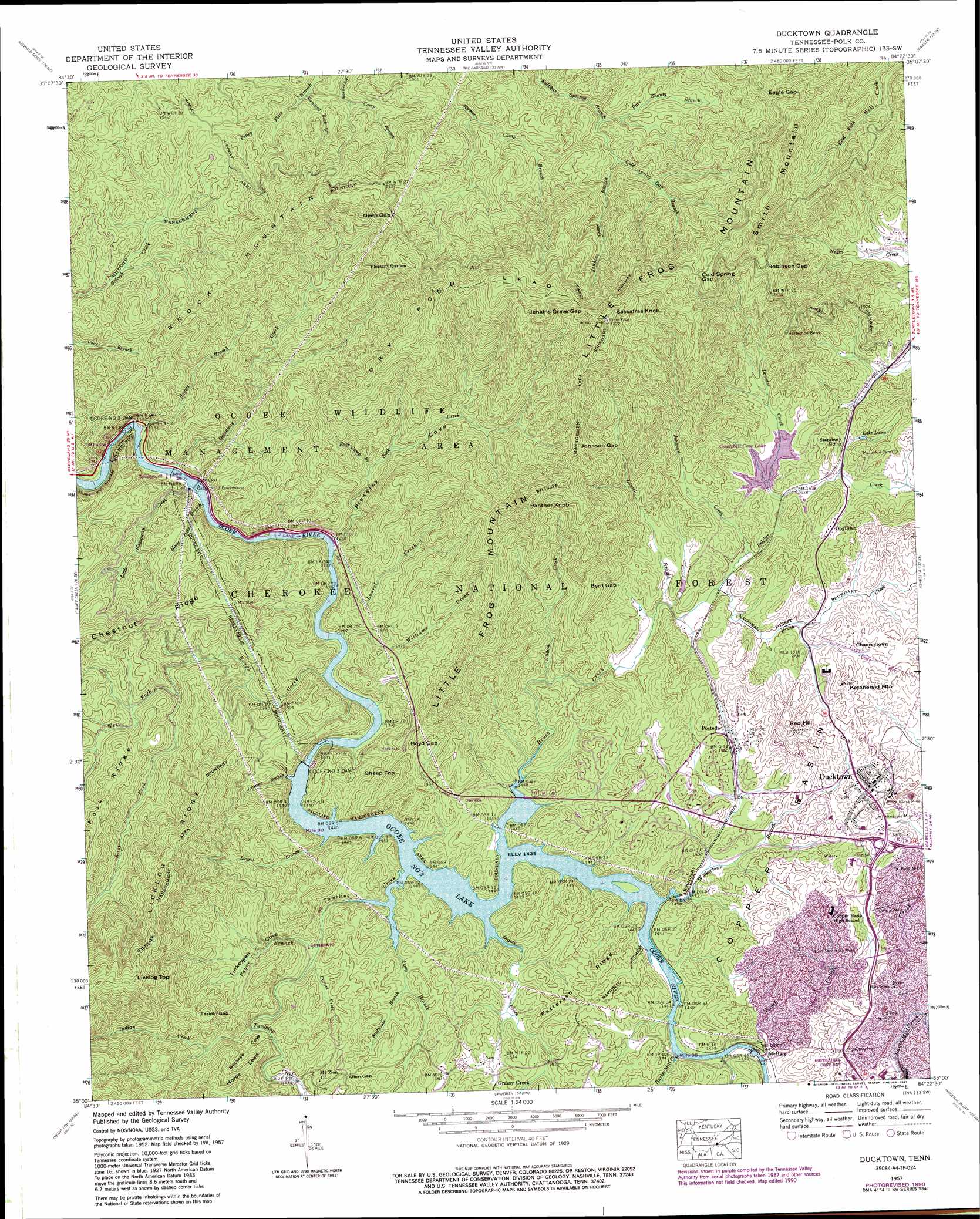
Ducktown Topo Map Tennessee
To zoom in, hover over the map of Ducktown
USGS Topo Quad 35084a4 - 1:24,000 scale
| Topo Map Name: | Ducktown |
| USGS Topo Quad ID: | 35084a4 |
| Print Size: | ca. 21 1/4" wide x 27" high |
| Southeast Coordinates: | 35° N latitude / 84.375° W longitude |
| Map Center Coordinates: | 35.0625° N latitude / 84.4375° W longitude |
| U.S. State: | TN |
| Filename: | o35084a4.jpg |
| Download Map JPG Image: | Ducktown topo map 1:24,000 scale |
| Map Type: | Topographic |
| Topo Series: | 7.5´ |
| Map Scale: | 1:24,000 |
| Source of Map Images: | United States Geological Survey (USGS) |
| Alternate Map Versions: |
Postelle TN 1936 Download PDF Buy paper map Ducktown TN 1957, updated 1959 Download PDF Buy paper map Ducktown TN 1957, updated 1972 Download PDF Buy paper map Ducktown TN 1957, updated 1976 Download PDF Buy paper map Ducktown TN 1957, updated 1991 Download PDF Buy paper map Ducktown TN 1999, updated 2001 Download PDF Buy paper map Ducktown TN 2003, updated 2004 Download PDF Buy paper map Ducktown TN 2011 Download PDF Buy paper map Ducktown TN 2013 Download PDF Buy paper map Ducktown TN 2016 Download PDF Buy paper map |
| FStopo: | US Forest Service topo Ducktown is available: Download FStopo PDF Download FStopo TIF |
1:24,000 Topo Quads surrounding Ducktown
Calhoun |
Etowah |
Mecca |
Tellico Plains |
Bald River Falls |
Benton |
Oswald Dome |
Mcfarland |
Farner |
Unaka |
Parksville |
Caney Creek |
Ducktown |
Isabella |
Persimmon Creek |
Tennga |
Hemp Top |
Epworth |
Mineral Bluff |
Culberson |
Crandall |
Dyer Gap |
Cashes Valley |
Blue Ridge |
Wilscot |
> Back to 35084a1 at 1:100,000 scale
> Back to 35084a1 at 1:250,000 scale
> Back to U.S. Topo Maps home
Ducktown topo map: Gazetteer
Ducktown: Basins
Copper Basin elevation 539m 1768′Hedden Grave elevation 524m 1719′
Ducktown: Bends
Horseshoe Bend elevation 701m 2299′Ducktown: Bridges
Rogers Bridge elevation 437m 1433′Ducktown: Dams
Campbell Cove Dam elevation 504m 1653′City Services Diversion Dam elevation 491m 1610′
F-Eleven Tailings Pond Dam elevation 448m 1469′
Ocoee Number Three Dam elevation 414m 1358′
Ocoee Number Three Dam elevation 348m 1141′
Ocoee Number Two Dam elevation 338m 1108′
Ducktown: Gaps
Allen Gap elevation 527m 1729′Boyd Gap elevation 541m 1774′
Byrd Gap elevation 620m 2034′
Cold Spring Gap elevation 855m 2805′
Deep Gap elevation 669m 2194′
Eagle Gap elevation 782m 2565′
Jenkins Grave Gap elevation 892m 2926′
Jep Notch elevation 805m 2641′
Johnson Gap elevation 784m 2572′
Robinson Gap elevation 795m 2608′
Tarkiln Gap elevation 619m 2030′
Ducktown: Mines
Boyd Mine elevation 512m 1679′Burra-Burra Mine elevation 548m 1797′
Central Mine elevation 490m 1607′
Hiwassee Mine elevation 533m 1748′
Mary Mine elevation 501m 1643′
Old Polk County Mine elevation 501m 1643′
Old Tennessee Mine elevation 497m 1630′
Ducktown: Parks
Thunder Rock Recreation Area elevation 396m 1299′Tumbling Creek Recreation Area elevation 447m 1466′
Ducktown: Populated Places
Chanceytown elevation 526m 1725′Ducktown elevation 528m 1732′
Grassy Creek elevation 469m 1538′
McHarg elevation 451m 1479′
Postelle elevation 475m 1558′
Ducktown: Post Offices
Postelle Post Office elevation 476m 1561′Ducktown: Reservoirs
Campbell Cove Lake elevation 504m 1653′City Services Diversion Lake elevation 491m 1610′
F-Eleven Tailings Pond elevation 448m 1469′
Lake Lamar elevation 516m 1692′
Ocoee Number Three Lake elevation 348m 1141′
Ocoee Number Three Lake elevation 435m 1427′
Ocoee Number Two Lake elevation 338m 1108′
Ducktown: Ridges
Chestnut Ridge elevation 575m 1886′Dry Pond Lead elevation 887m 2910′
Fork Ridge elevation 645m 2116′
Patterson Ridge elevation 514m 1686′
Ducktown: Springs
Beech Spring elevation 511m 1676′Ducktown: Streams
Barker Mill Creek elevation 453m 1486′Barker Mill Creek elevation 437m 1433′
Belcher Creek elevation 479m 1571′
Belltown Creek elevation 464m 1522′
Brush Creek elevation 437m 1433′
Carters Creek elevation 463m 1519′
Chestnut Branch elevation 465m 1525′
Cold Spring Gap Branch elevation 547m 1794′
Deweese Creek elevation 495m 1624′
East Fork Rough Creek elevation 473m 1551′
Gassaway Creek elevation 341m 1118′
Grassy Creek elevation 482m 1581′
Grassy Creek elevation 437m 1433′
Horse Bone Branch elevation 345m 1131′
Jenkins Grave Branch elevation 518m 1699′
Johnson Branch elevation 437m 1433′
Johnson Creek elevation 484m 1587′
Laurel Branch elevation 437m 1433′
Laurel Branch elevation 474m 1555′
Laurel Creek elevation 376m 1233′
Little Gassaway Creek elevation 343m 1125′
Long Branch elevation 437m 1433′
North Potato Creek elevation 438m 1437′
Pace Shanty Branch elevation 514m 1686′
Payne Branch elevation 450m 1476′
Rock Camp Branch elevation 435m 1427′
Rock Creek elevation 373m 1223′
Rogers Branch elevation 344m 1128′
Rough Creek elevation 399m 1309′
Sholer Branch elevation 475m 1558′
Standing Rock Branch elevation 424m 1391′
Stillhouse Branch elevation 466m 1528′
Tumbling Creek elevation 437m 1433′
Tumbling Creek elevation 475m 1558′
Walkertown Branch elevation 437m 1433′
West Fork Rough Creek elevation 473m 1551′
Wildcat Creek elevation 445m 1459′
Williams Creek elevation 402m 1318′
Ducktown: Summits
Brock Mountain elevation 758m 2486′Ketchersid Mountain elevation 583m 1912′
Licklog Top elevation 901m 2956′
Little Frog Mountain elevation 1017m 3336′
Panther Knob elevation 895m 2936′
Potato Hill elevation 587m 1925′
Red Hill elevation 624m 2047′
Sassafras Knob elevation 1016m 3333′
Sheep Top elevation 609m 1998′
Smith Mountain elevation 946m 3103′
Ducktown: Trails
Dry Pond Lead Trail elevation 722m 2368′Licklog Trail elevation 659m 2162′
Rock Creek Trail elevation 828m 2716′
Rogers Branch Trail elevation 415m 1361′
Ducktown: Valleys
Buckeye Cove elevation 467m 1532′Pressley Cove elevation 373m 1223′
Turkeypen Cove elevation 449m 1473′
Ducktown digital topo map on disk
Buy this Ducktown topo map showing relief, roads, GPS coordinates and other geographical features, as a high-resolution digital map file on DVD: