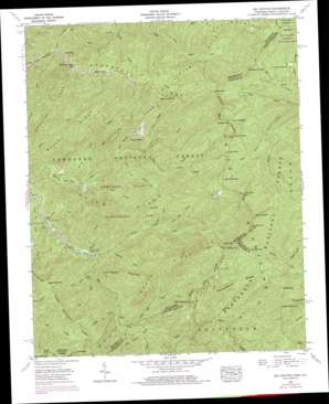
Big Junction Topo Map Tennessee
To zoom in, hover over the map of Big Junction
USGS Topo Quad 35084c1 - 1:24,000 scale
| Topo Map Name: | Big Junction |
| USGS Topo Quad ID: | 35084c1 |
| Print Size: | ca. 21 1/4" wide x 27" high |
| Southeast Coordinates: | 35.25° N latitude / 84° W longitude |
| Map Center Coordinates: | 35.3125° N latitude / 84.0625° W longitude |
| U.S. States: | TN, NC |
| Filename: | o35084c1.jpg |
| Download Map JPG Image: | Big Junction topo map 1:24,000 scale |
| Map Type: | Topographic |
| Topo Series: | 7.5´ |
| Map Scale: | 1:24,000 |
| Source of Map Images: | United States Geological Survey (USGS) |
| Alternate Map Versions: |
Big Junction TN 1927 Download PDF Buy paper map Big Junction TN 1957, updated 1959 Download PDF Buy paper map Big Junction TN 1957, updated 1963 Download PDF Buy paper map Big Junction TN 1957, updated 1971 Download PDF Buy paper map Big Junction TN 1957, updated 1978 Download PDF Buy paper map Big Junction TN 2003, updated 2004 Download PDF Buy paper map Big Junction TN 2011 Download PDF Buy paper map Big Junction TN 2013 Download PDF Buy paper map Big Junction TN 2016 Download PDF Buy paper map |
| FStopo: | US Forest Service topo Big Junction is available: Download FStopo PDF Download FStopo TIF |
1:24,000 Topo Quads surrounding Big Junction
> Back to 35084a1 at 1:100,000 scale
> Back to 35084a1 at 1:250,000 scale
> Back to U.S. Topo Maps home
Big Junction topo map: Gazetteer
Big Junction: Crossings
Fain Ford elevation 937m 3074′Big Junction: Dams
Rowe Lake Dam elevation 1059m 3474′Big Junction: Flats
Stratton Meadows elevation 1315m 4314′Stratton Meadows elevation 1308m 4291′
Swan Meadows elevation 1293m 4242′
Whigg Meadow elevation 1503m 4931′
Big Junction: Gaps
Beech Gap elevation 1366m 4481′Beech Gap elevation 1366m 4481′
Deep Gap elevation 1063m 3487′
Eagle Gap elevation 1103m 3618′
Grassy Gap elevation 1141m 3743′
Grassy Gap elevation 1096m 3595′
Hogjaw Gap elevation 1492m 4895′
Hoglaw Gap elevation 1492m 4895′
Mud Gap elevation 1365m 4478′
Mud Gap elevation 1365m 4478′
Red Log Gap elevation 1117m 3664′
Red Log Gap elevation 1127m 3697′
Stratton Gap elevation 1301m 4268′
Stratton Gap elevation 1307m 4288′
Big Junction: Parks
Big Oak Cove Recreation Area elevation 776m 2545′Dam Creek Recreation Area elevation 597m 1958′
Davis Creek Recreation Area elevation 691m 2267′
Fall Branch Scenic Area elevation 1129m 3704′
Spivey Cove Recreation Area elevation 583m 1912′
State Line Recreation Area elevation 785m 2575′
Big Junction: Ranges
Unicoi Mountains elevation 1626m 5334′Big Junction: Reservoirs
Rowe Lake elevation 1059m 3474′Big Junction: Ridges
Brush Mountain elevation 1223m 4012′Brushy Ridge elevation 882m 2893′
Hampton Lead elevation 935m 3067′
McIntyre Lead elevation 1002m 3287′
Peckerwood Ridge elevation 1326m 4350′
Pine Ridge elevation 1318m 4324′
Rough Ridge elevation 1262m 4140′
Sassafras Ridge elevation 1200m 3937′
State Ridge elevation 1282m 4206′
Sugar Mountain Lead elevation 1173m 3848′
Whigg Ridge elevation 1122m 3681′
Big Junction: Streams
Bearpen Branch elevation 1184m 3884′Big Cove Branch elevation 630m 2066′
Big Oak Cove Creek elevation 773m 2536′
Birch Branch elevation 676m 2217′
Bob Branch elevation 1220m 4002′
Bob Creek elevation 971m 3185′
Davis Creek elevation 681m 2234′
Falls Branch elevation 896m 2939′
Gold Cove Branch elevation 854m 2801′
Grassy Branch elevation 745m 2444′
Green Cove Branch elevation 559m 1833′
Holder Cove Branch elevation 755m 2477′
Indian Branch elevation 799m 2621′
Jenks Branch elevation 813m 2667′
Johns Branch elevation 1085m 3559′
Laurel Branch elevation 609m 1998′
Mangan Branch elevation 827m 2713′
Meadow Branch elevation 701m 2299′
Mistletoe Creek elevation 953m 3126′
Peckerwood Creek elevation 880m 2887′
Pleasant Branch elevation 626m 2053′
Roaring Branch elevation 942m 3090′
Rough Ridge Creek elevation 785m 2575′
Round Mountain Branch elevation 1075m 3526′
Round Mountain Branch elevation 663m 2175′
Service Tree Branch elevation 668m 2191′
Spivey Creek elevation 571m 1873′
Sugar Cove Branch elevation 701m 2299′
Sycamore Creek elevation 637m 2089′
Tipton Creek elevation 794m 2604′
Whigg Branch elevation 1177m 3861′
Big Junction: Summits
Big Junction elevation 1626m 5334′Big Junction elevation 1632m 5354′
Bob Bald elevation 1606m 5269′
Dillard Top elevation 1434m 4704′
Grassy Top elevation 1514m 4967′
Grassy Top elevation 1514m 4967′
Haw Knob elevation 1668m 5472′
Hawk Knob elevation 1301m 4268′
Hemlock Knob elevation 1211m 3973′
Johns Knob elevation 1494m 4901′
Johns Knob elevation 1489m 4885′
Laurel Top elevation 1616m 5301′
Little Bald elevation 1220m 4002′
Little Bald elevation 1219m 3999′
Little Haw Knob elevation 1562m 5124′
Little Haw Knob elevation 1562m 5124′
Lookingglass Mountain elevation 1038m 3405′
Mitchell Lick elevation 1393m 4570′
Pantherflat Top elevation 1430m 4691′
Rattlesnake Rock elevation 1239m 4064′
Round Mountain elevation 927m 3041′
Strawberry Knob elevation 1413m 4635′
Strawberry Knob elevation 1413m 4635′
Sugar Mountain elevation 1102m 3615′
Big Junction: Trails
Big Indian Branch Trail elevation 976m 3202′Falls Branch Trail elevation 1021m 3349′
Grassy Branch Trail elevation 930m 3051′
Hemlock Trail elevation 714m 2342′
Jeffrey Trail elevation 1189m 3900′
Laurel Branch Trail elevation 727m 2385′
McNabb Creek Trail elevation 682m 2237′
South Fork Citico Trail elevation 1015m 3330′
Sugar Cove Trail elevation 901m 2956′
Sugar Mountain Trail elevation 1055m 3461′
Whigg Ridge Trail elevation 955m 3133′
Big Junction: Valleys
Kirkland Cove elevation 671m 2201′Queen Cove elevation 597m 1958′
Big Junction digital topo map on disk
Buy this Big Junction topo map showing relief, roads, GPS coordinates and other geographical features, as a high-resolution digital map file on DVD:


