Rafter Topo Map Tennessee
To zoom in, hover over the map of Rafter
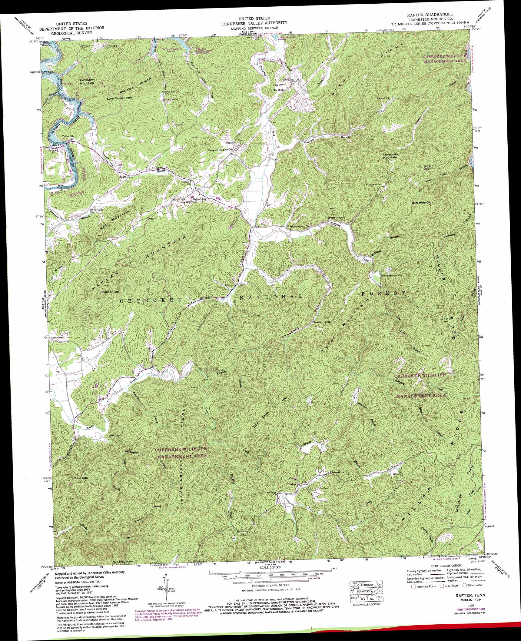
USGS Topo Quad 35084d2 - 1:24,000 scale
| Topo Map Name: | Rafter |
| USGS Topo Quad ID: | 35084d2 |
| Print Size: | ca. 21 1/4" wide x 27" high |
| Southeast Coordinates: | 35.375° N latitude / 84.125° W longitude |
| Map Center Coordinates: | 35.4375° N latitude / 84.1875° W longitude |
| U.S. State: | TN |
| Filename: | o35084d2.jpg |
| Download Map JPG Image: | Rafter topo map 1:24,000 scale |
| Map Type: | Topographic |
| Topo Series: | 7.5´ |
| Map Scale: | 1:24,000 |
| Source of Map Images: | United States Geological Survey (USGS) |
| Alternate Map Versions: |
Rafter TN 1933 Download PDF Buy paper map Rafter TN 1957, updated 1959 Download PDF Buy paper map Rafter TN 1957, updated 1968 Download PDF Buy paper map Rafter TN 1957, updated 1978 Download PDF Buy paper map Rafter TN 1957, updated 1986 Download PDF Buy paper map Rafter TN 1984, updated 1989 Download PDF Buy paper map Rafter TN 2003, updated 2004 Download PDF Buy paper map Rafter TN 2011 Download PDF Buy paper map Rafter TN 2013 Download PDF Buy paper map Rafter TN 2016 Download PDF Buy paper map |
| FStopo: | US Forest Service topo Rafter is available: Download FStopo PDF Download FStopo TIF |
1:24,000 Topo Quads surrounding Rafter
Philadelphia |
Loudon |
Meadow |
Binfield |
Blockhouse |
Sweetwater |
Madisonville |
Vonore |
Tallassee |
Calderwood |
Englewood |
Mount Vernon |
Rafter |
Whiteoak Flats |
Tapoco |
Mecca |
Tellico Plains |
Bald River Falls |
Big Junction |
Santeetlah Creek |
Mcfarland |
Farner |
Unaka |
Mcdaniel Bald |
Marble |
> Back to 35084a1 at 1:100,000 scale
> Back to 35084a1 at 1:250,000 scale
> Back to U.S. Topo Maps home
Rafter topo map: Gazetteer
Rafter: Bridges
Sloan Bridge elevation 253m 830′Rafter: Gaps
Hells Hole Gap elevation 474m 1555′King Gap elevation 433m 1420′
Rafter: Parks
Cherokee Wildlife Management Area elevation 593m 1945′Rafter: Populated Places
Acorn elevation 260m 853′Ballplay elevation 278m 912′
Chestnut Valley elevation 313m 1026′
Rafter elevation 411m 1348′
Tariffville elevation 279m 915′
Rafter: Ridges
Glenn Ridge elevation 434m 1423′Huckleberry Ridge elevation 484m 1587′
Miller Ridge elevation 649m 2129′
Rafter: Streams
Amerine Branch elevation 269m 882′Bivens Branch elevation 456m 1496′
Cagle Branch elevation 248m 813′
Carden Branch elevation 265m 869′
Cowmire Branch elevation 331m 1085′
Hampton Branch elevation 422m 1384′
Harding Creek elevation 313m 1026′
Harris Branch elevation 248m 813′
Hells Hole Branch elevation 287m 941′
Lost Cove Branch elevation 360m 1181′
Millsaps Branch elevation 248m 813′
Nickels Branch elevation 348m 1141′
Pearson Branch elevation 255m 836′
Ramsey Branch elevation 285m 935′
Shingletree Branch elevation 283m 928′
Stratton Branch elevation 248m 813′
Tanyard Branch elevation 251m 823′
Williams Branch elevation 291m 954′
Rafter: Summits
Birchfield Mountain elevation 368m 1207′Cane Creek Mountain elevation 560m 1837′
Canebrake Mountain elevation 454m 1489′
Harlan Mountain elevation 565m 1853′
Lynn Carden Mountain elevation 351m 1151′
Mose Mountain elevation 491m 1610′
Peaked Top elevation 565m 1853′
Red Mountain elevation 406m 1332′
Turkeypen Mountain elevation 368m 1207′
Tyler Mountain elevation 560m 1837′
Rafter: Valleys
Chestnut Valley elevation 270m 885′Rafter digital topo map on disk
Buy this Rafter topo map showing relief, roads, GPS coordinates and other geographical features, as a high-resolution digital map file on DVD: