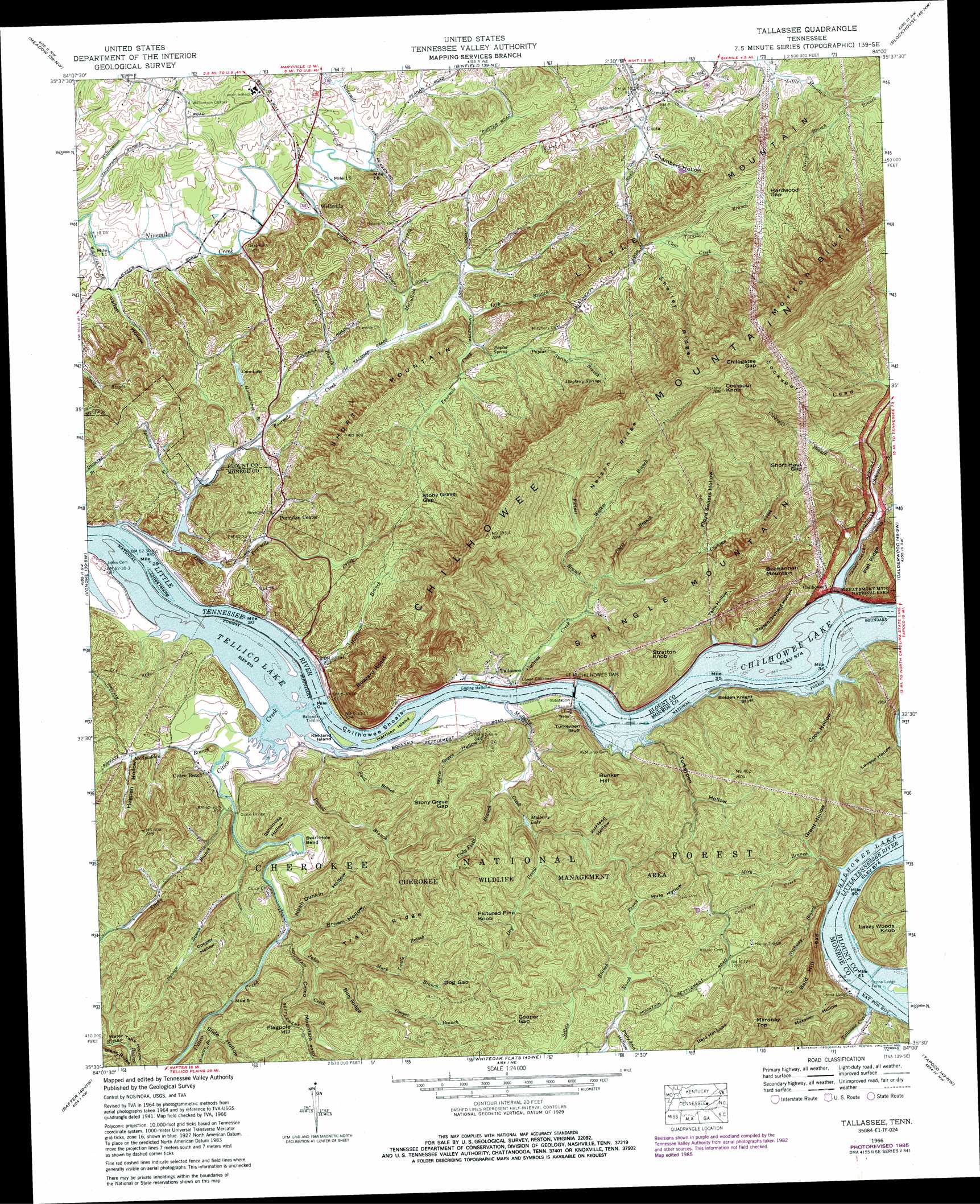
Tallassee Topo Map Tennessee
To zoom in, hover over the map of Tallassee
USGS Topo Quad 35084e1 - 1:24,000 scale
| Topo Map Name: | Tallassee |
| USGS Topo Quad ID: | 35084e1 |
| Print Size: | ca. 21 1/4" wide x 27" high |
| Southeast Coordinates: | 35.5° N latitude / 84° W longitude |
| Map Center Coordinates: | 35.5625° N latitude / 84.0625° W longitude |
| U.S. State: | TN |
| Filename: | o35084e1.jpg |
| Download Map JPG Image: | Tallassee topo map 1:24,000 scale |
| Map Type: | Topographic |
| Topo Series: | 7.5´ |
| Map Scale: | 1:24,000 |
| Source of Map Images: | United States Geological Survey (USGS) |
| Alternate Map Versions: |
Tallassee TN 1935 Download PDF Buy paper map Tallassee TN 1941, updated 1959 Download PDF Buy paper map Tallassee TN 1942 Download PDF Buy paper map Tallassee TN 1966, updated 1968 Download PDF Buy paper map Tallassee TN 1966, updated 1985 Download PDF Buy paper map Tallassee TN 1966, updated 1985 Download PDF Buy paper map Tallassee TN 2003, updated 2004 Download PDF Buy paper map Tallassee TN 2011 Download PDF Buy paper map Tallassee TN 2013 Download PDF Buy paper map Tallassee TN 2016 Download PDF Buy paper map |
| FStopo: | US Forest Service topo Tallassee is available: Download FStopo PDF Download FStopo TIF |
1:24,000 Topo Quads surrounding Tallassee
Lenoir City |
Concord |
Louisville |
Maryville |
Wildwood |
Loudon |
Meadow |
Binfield |
Blockhouse |
Kinzel Springs |
Madisonville |
Vonore |
Tallassee |
Calderwood |
Cades Cove |
Mount Vernon |
Rafter |
Whiteoak Flats |
Tapoco |
Fontana Dam |
Tellico Plains |
Bald River Falls |
Big Junction |
Santeetlah Creek |
Robbinsville |
> Back to 35084e1 at 1:100,000 scale
> Back to 35084a1 at 1:250,000 scale
> Back to U.S. Topo Maps home
Tallassee topo map: Gazetteer
Tallassee: Bars
Chilhowee Shoals elevation 248m 813′Fish Trap Shoals elevation 248m 813′
Four Mile Creek Shoals elevation 248m 813′
McMurray Shoals elevation 266m 872′
Stratton Shoals elevation 266m 872′
Tallassee: Bends
Swirl Hole Bend elevation 253m 830′Tallassee: Bridges
Babcock Trestle elevation 248m 813′Citico Bridge elevation 248m 813′
Tallassee: Cliffs
Bolden Knight Bluff elevation 286m 938′Morton Bluff elevation 689m 2260′
Turkeypen Bluff elevation 311m 1020′
Tallassee: Crossings
Jones Ferry (historical) elevation 248m 813′Tallassee Ford (historical) elevation 266m 872′
Tallassee: Dams
Chilhowee Dam elevation 249m 816′Turkeypen Lake Dam elevation 377m 1236′
Tallassee: Gaps
Chilogatee Gap elevation 747m 2450′Cooper Gap elevation 456m 1496′
Dog Gap elevation 419m 1374′
Hardwood Gap elevation 393m 1289′
Short Haul Gap elevation 429m 1407′
Stony Grave Gap elevation 367m 1204′
Stony Grave Gap elevation 348m 1141′
Tallassee: Islands
Harrison Island elevation 248m 813′Jones Island elevation 248m 813′
Kirkland Island elevation 248m 813′
Tallassee: Parks
Citico Recreation Area elevation 251m 823′Harrison Branch Recreation Area elevation 249m 816′
Tallassee Recreation Area elevation 248m 813′
Tallassee: Populated Places
Allegheny Springs (historical) elevation 387m 1269′Caringer (historical) elevation 408m 1338′
Chilhowee elevation 269m 882′
Chilhowey (historical) elevation 266m 872′
Chota elevation 280m 918′
Citico (historical) elevation 248m 813′
Citico Beach elevation 254m 833′
Halfway Town (historical) elevation 274m 898′
Ipe (historical) elevation 266m 872′
Lanier elevation 300m 984′
Pumpkin Center elevation 272m 892′
Tallassee elevation 250m 820′
Tellassee (historical) elevation 266m 872′
Wellsville elevation 269m 882′
Tallassee: Post Offices
Tallassee Post Office elevation 250m 820′Tallassee: Reservoirs
Chilhowee Lake elevation 249m 816′Cove Lake elevation 271m 889′
Mulberry Lake elevation 281m 921′
Turkeypen Lake elevation 377m 1236′
Tallassee: Ridges
Billy Ridge elevation 415m 1361′Citico Mountain elevation 361m 1184′
Cockspur Lead elevation 560m 1837′
Nelson Ridge elevation 541m 1774′
Shelley Ridge elevation 441m 1446′
Trail Ridge elevation 454m 1489′
Tallassee: Springs
Allegheny Springs elevation 396m 1299′Poplar Spring elevation 276m 905′
Tallassee: Streams
Carringer Branch elevation 266m 872′Chris Branch elevation 280m 918′
Citico Creek elevation 248m 813′
Clear Creek elevation 274m 898′
Cochran Creek elevation 248m 813′
Cockspur Branch elevation 300m 984′
Cody Field Branch elevation 266m 872′
Cooper Branch elevation 303m 994′
Cure-al Branch elevation 297m 974′
Dry Prong elevation 291m 954′
Duncan Branch elevation 264m 866′
Duncan Branch elevation 248m 813′
Duncan Branch elevation 259m 849′
Fortner Branch elevation 277m 908′
Fourmile Creek elevation 248m 813′
Hammontree Branch elevation 249m 816′
Harrison Branch elevation 248m 813′
Irwin Branch elevation 253m 830′
Jakes Creek elevation 254m 833′
Jakes Creek elevation 255m 836′
Lick Branch elevation 262m 859′
Little Fourmile Creek elevation 248m 813′
McCulloch Branch elevation 259m 849′
McSpadden Branch elevation 248m 813′
Miry Branch elevation 301m 987′
Mulberry Creek elevation 248m 813′
Mulberry Creek elevation 382m 1253′
Murk Branch elevation 275m 902′
Nighway Branch elevation 267m 875′
Parnell Branch elevation 248m 813′
Poplar Spring Branch elevation 268m 879′
Rough Prong elevation 304m 997′
Ryall Branch elevation 248m 813′
Sellers Branch elevation 374m 1227′
Smoky Branch elevation 248m 813′
Spradling Branch elevation 248m 813′
Tallasee Creek elevation 266m 872′
Tarkiln Branch elevation 307m 1007′
Trestle Branch elevation 343m 1125′
Walker Branch elevation 348m 1141′
Tallassee: Summits
Buchannan Mountain elevation 508m 1666′Bunker Hill elevation 434m 1423′
Buzzard Roost elevation 467m 1532′
Citico Mountain elevation 424m 1391′
Cockspur Knob elevation 820m 2690′
Flagpole Hill elevation 416m 1364′
Lakey Woods Knob elevation 428m 1404′
Maroney Top elevation 515m 1689′
Pictured Pine Knob elevation 453m 1486′
Shingle Mountain elevation 488m 1601′
Short Mountain elevation 393m 1289′
Stratton Knob elevation 464m 1522′
Tallassee: Valleys
Brown Hollow elevation 264m 866′Bryant Hollow elevation 267m 875′
Chambers Hollow elevation 279m 915′
Cook Hollow elevation 266m 872′
Cooper Hollow elevation 278m 912′
Floyd Sellers Hollow elevation 309m 1013′
Grant Hollow elevation 314m 1030′
Hogpen Hollow elevation 266m 872′
Hute Hollow elevation 364m 1194′
Kirkland Hollow elevation 338m 1108′
Lawson Hollow elevation 268m 879′
Maroney Hollow elevation 269m 882′
Noah Dunkin Hollow elevation 256m 839′
Polly Ann Hollow elevation 383m 1256′
Slide Hollow elevation 263m 862′
Slide Hollow elevation 271m 889′
Stillhouse Hollow elevation 271m 889′
Stony Grave Hollow elevation 250m 820′
Tank Hollow elevation 267m 875′
Tipton Orchard Hollow elevation 267m 875′
Turkeypen Hollow elevation 266m 872′
Vaden Hollow elevation 261m 856′
Tallassee digital topo map on disk
Buy this Tallassee topo map showing relief, roads, GPS coordinates and other geographical features, as a high-resolution digital map file on DVD: