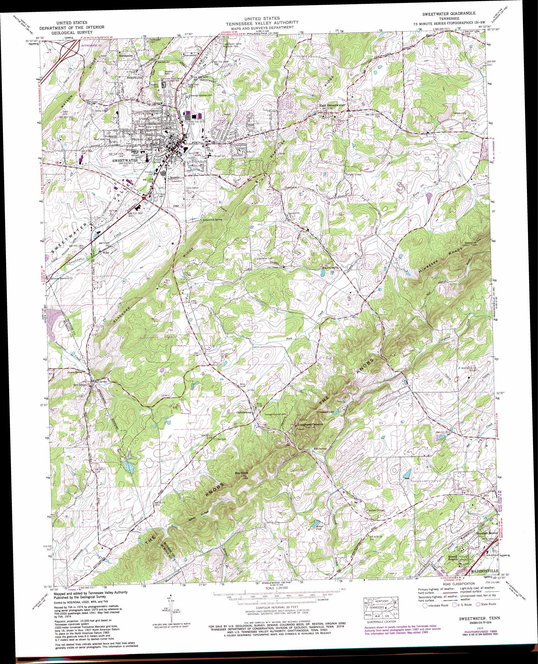
Sweetwater Topo Map Tennessee
To zoom in, hover over the map of Sweetwater
USGS Topo Quad 35084e4 - 1:24,000 scale
| Topo Map Name: | Sweetwater |
| USGS Topo Quad ID: | 35084e4 |
| Print Size: | ca. 21 1/4" wide x 27" high |
| Southeast Coordinates: | 35.5° N latitude / 84.375° W longitude |
| Map Center Coordinates: | 35.5625° N latitude / 84.4375° W longitude |
| U.S. State: | TN |
| Filename: | o35084e4.jpg |
| Download Map JPG Image: | Sweetwater topo map 1:24,000 scale |
| Map Type: | Topographic |
| Topo Series: | 7.5´ |
| Map Scale: | 1:24,000 |
| Source of Map Images: | United States Geological Survey (USGS) |
| Alternate Map Versions: |
Sweetwater TN 1936 Download PDF Buy paper map Sweetwater TN 1941, updated 1954 Download PDF Buy paper map Sweetwater TN 1942 Download PDF Buy paper map Sweetwater TN 1942 Download PDF Buy paper map Sweetwater TN 1974, updated 1976 Download PDF Buy paper map Sweetwater TN 1974, updated 1989 Download PDF Buy paper map Sweetwater TN 2010 Download PDF Buy paper map Sweetwater TN 2013 Download PDF Buy paper map Sweetwater TN 2016 Download PDF Buy paper map |
1:24,000 Topo Quads surrounding Sweetwater
Rockwood |
Bacon Gap |
Cave Creek |
Lenoir City |
Concord |
Ten Mile |
Pattie Gap |
Philadelphia |
Loudon |
Meadow |
Tranquillity |
Niota |
Sweetwater |
Madisonville |
Vonore |
Riceville |
Athens |
Englewood |
Mount Vernon |
Rafter |
Calhoun |
Etowah |
Mecca |
Tellico Plains |
Bald River Falls |
> Back to 35084e1 at 1:100,000 scale
> Back to 35084a1 at 1:250,000 scale
> Back to U.S. Topo Maps home
Sweetwater topo map: Gazetteer
Sweetwater: Airports
Monroe County Airport elevation 307m 1007′Sweetwater: Crossings
Interchange 62 elevation 286m 938′Sweetwater: Dams
Ballard Mill Settlement Dam elevation 300m 984′Sweetwater Creek Watershed Dam Number Fifteen elevation 296m 971′
Sweetwater Creek Watershed Dam Number One elevation 290m 951′
Sweetwater: Lakes
Craighead Lake elevation 338m 1108′Kinser Pond elevation 303m 994′
Sweetwater: Mines
Ewing Mine elevation 308m 1010′Heiskell Mine elevation 300m 984′
Sweetwater: Parks
Craighead Caverns elevation 375m 1230′Sweetwater: Populated Places
Bell Spring elevation 299m 980′Christianburg elevation 330m 1082′
East Sweetwater elevation 334m 1095′
Northpoint elevation 348m 1141′
Sequoyah Estates elevation 310m 1017′
Sherril Heights elevation 298m 977′
Sweetwater elevation 278m 912′
Wood elevation 283m 928′
Sweetwater: Post Offices
Sweetwater Post Office elevation 278m 912′Sweetwater: Reservoirs
Ballard Mill Lead Mine Pond elevation 300m 984′Sweetwater Creek Project Lake elevation 296m 971′
Sweetwater Creek Watershed Number One Reservoir elevation 290m 951′
Sweetwater: Ridges
Blackoak Ridge elevation 385m 1263′Sweetwater: Springs
Bell Spring elevation 301m 987′Cannon Spring elevation 277m 908′
Dugan Spring elevation 298m 977′
Howard Spring elevation 302m 990′
Kile Springs elevation 306m 1003′
Kilpatrick Spring elevation 290m 951′
Sweetwater: Summits
Hiwassee Knobs elevation 402m 1318′Roy Knob elevation 469m 1538′
Sweetwater: Valleys
Safety Hollow elevation 312m 1023′Sweetwater digital topo map on disk
Buy this Sweetwater topo map showing relief, roads, GPS coordinates and other geographical features, as a high-resolution digital map file on DVD: