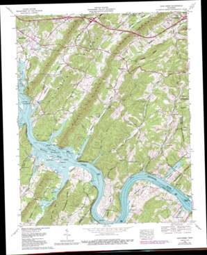
Cave Creek Topo Map Tennessee
To zoom in, hover over the map of Cave Creek
USGS Topo Quad 35084g4 - 1:24,000 scale
| Topo Map Name: | Cave Creek |
| USGS Topo Quad ID: | 35084g4 |
| Print Size: | ca. 21 1/4" wide x 27" high |
| Southeast Coordinates: | 35.75° N latitude / 84.375° W longitude |
| Map Center Coordinates: | 35.8125° N latitude / 84.4375° W longitude |
| U.S. State: | TN |
| Filename: | o35084g4.jpg |
| Download Map JPG Image: | Cave Creek topo map 1:24,000 scale |
| Map Type: | Topographic |
| Topo Series: | 7.5´ |
| Map Scale: | 1:24,000 |
| Source of Map Images: | United States Geological Survey (USGS) |
| Alternate Map Versions: |
Cave Creek TN 1936 Download PDF Buy paper map Cave Creek TN 1940 Download PDF Buy paper map Cave Creek TN 1953, updated 1955 Download PDF Buy paper map Cave Creek TN 1968, updated 1972 Download PDF Buy paper map Cave Creek TN 1968, updated 1979 Download PDF Buy paper map Cave Creek TN 1968, updated 1990 Download PDF Buy paper map Cave Creek TN 2010 Download PDF Buy paper map Cave Creek TN 2013 Download PDF Buy paper map Cave Creek TN 2016 Download PDF Buy paper map |
1:24,000 Topo Quads surrounding Cave Creek
> Back to 35084e1 at 1:100,000 scale
> Back to 35084a1 at 1:250,000 scale
> Back to U.S. Topo Maps home
Cave Creek topo map: Gazetteer
Cave Creek: Bars
Bacon Shoals elevation 226m 741′Bogarts Shoals elevation 226m 741′
Pond Creek Shoals elevation 226m 741′
Seven Islands Shoals elevation 226m 741′
Sweet Water Shoals elevation 226m 741′
Wilson Island Shoals elevation 226m 741′
Cave Creek: Bends
Matlock Bend elevation 248m 813′Wright Bend elevation 255m 836′
Cave Creek: Cliffs
Marble Bluff elevation 247m 810′Paint Rock Bluff elevation 246m 807′
Cave Creek: Crossings
Huffines Ferry (historical) elevation 226m 741′Interchange 355 elevation 237m 777′
Interchange 356 elevation 250m 820′
Interchange 360 elevation 237m 777′
Long Island Ferry (historical) elevation 226m 741′
Paint Rock Ferry (historical) elevation 226m 741′
Cave Creek: Islands
Bush Island elevation 226m 741′Huffine Island elevation 226m 741′
Matlock Island elevation 226m 741′
Pond Creek Island (historical) elevation 226m 741′
Seven Islands elevation 226m 741′
Sweetwater Island elevation 226m 741′
Wilson Island elevation 226m 741′
Cave Creek: Parks
Paint Rock Wildlife Management Area elevation 226m 741′Cave Creek: Populated Places
Bradbury elevation 254m 833′Cave Creek elevation 271m 889′
Cedar Grove elevation 265m 869′
Dogwood elevation 293m 961′
Dogwood Shores elevation 258m 846′
Eblen Estates elevation 231m 757′
Edgewater Estates elevation 250m 820′
Hamilton Subdivision elevation 255m 836′
High Point elevation 275m 902′
Lake-A-Wana elevation 250m 820′
Lawnville Meadows elevation 260m 853′
New Midway elevation 281m 921′
Paint Rock (historical) elevation 227m 744′
Paint Rock Farm Lake Estates elevation 234m 767′
Poplar Springs elevation 248m 813′
Twin Oaks elevation 239m 784′
Cave Creek: Reservoirs
Rose Bailey Lake elevation 232m 761′Cave Creek: Ridges
Barber Shaft Ridge elevation 319m 1046′Dug Ridge elevation 340m 1115′
Huckleberry Ridge elevation 296m 971′
Cave Creek: Springs
Gaylon Spring elevation 248m 813′Huffine Spring elevation 245m 803′
Love Spring elevation 238m 780′
Poplar Spring elevation 251m 823′
Rodgers Spring elevation 234m 767′
Cave Creek: Streams
Buck Creek elevation 226m 741′Cave Creek elevation 226m 741′
Cave Spring Branch elevation 226m 741′
Greasy Run Creek elevation 226m 741′
Hines Creek elevation 226m 741′
Holder Ford Branch elevation 246m 807′
Huffine Branch elevation 226m 741′
Johnson Valley Creek elevation 226m 741′
Ladd Creek elevation 239m 784′
Mill Creek elevation 228m 748′
Paint Rock Creek elevation 226m 741′
Polecat Creek elevation 226m 741′
Ray Branch elevation 226m 741′
Richland Creek elevation 226m 741′
Rodgers Branch elevation 226m 741′
Smith Creek elevation 226m 741′
Spring Branch elevation 226m 741′
Wolf Creek elevation 226m 741′
Cave Creek: Summits
High Point elevation 378m 1240′Cave Creek: Valleys
Greasy Run Valley elevation 227m 744′Hines Valley elevation 226m 741′
Johnston Valley elevation 226m 741′
Cave Creek digital topo map on disk
Buy this Cave Creek topo map showing relief, roads, GPS coordinates and other geographical features, as a high-resolution digital map file on DVD:


