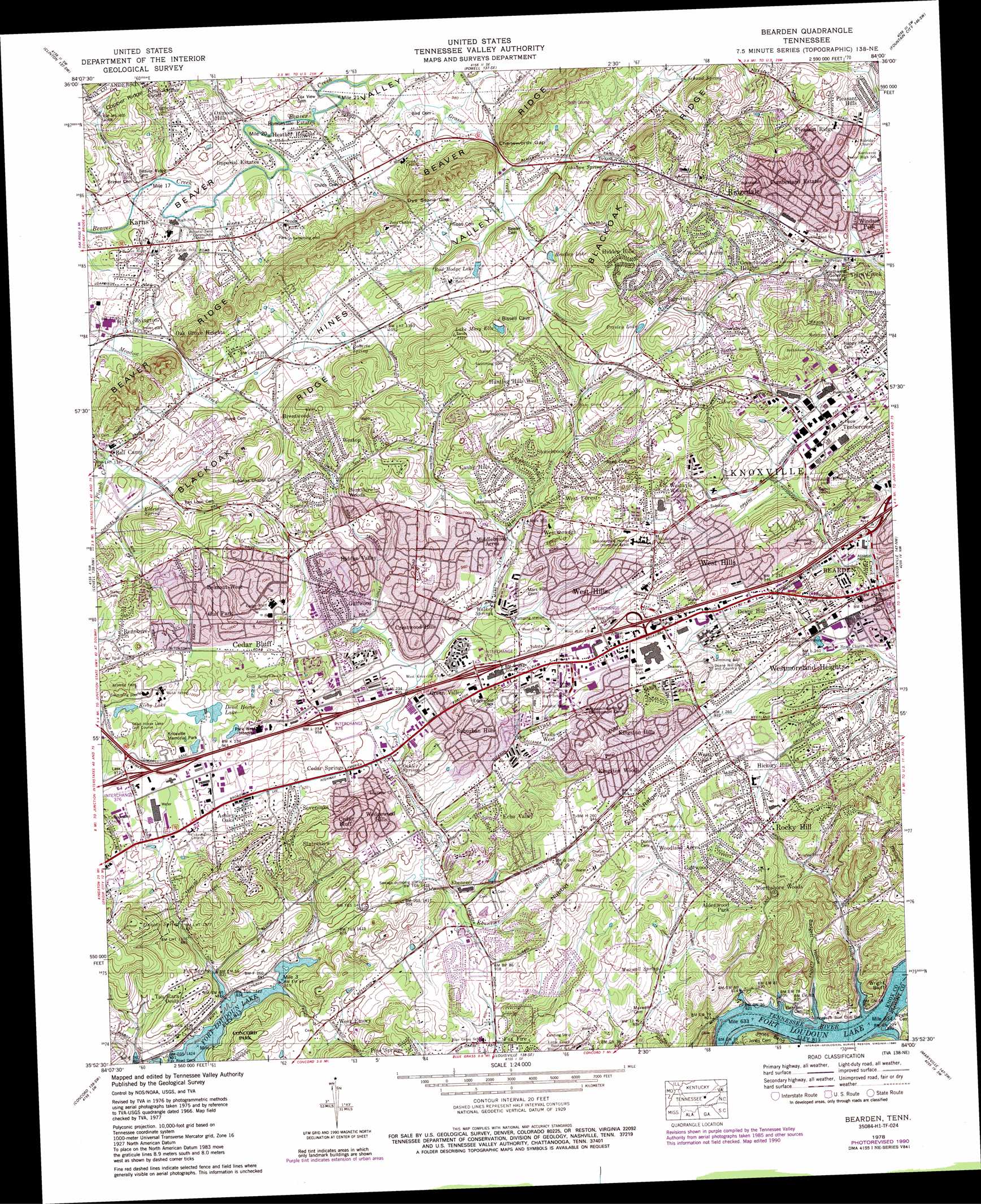
Bearden Topo Map Tennessee
To zoom in, hover over the map of Bearden
USGS Topo Quad 35084h1 - 1:24,000 scale
| Topo Map Name: | Bearden |
| USGS Topo Quad ID: | 35084h1 |
| Print Size: | ca. 21 1/4" wide x 27" high |
| Southeast Coordinates: | 35.875° N latitude / 84° W longitude |
| Map Center Coordinates: | 35.9375° N latitude / 84.0625° W longitude |
| U.S. State: | TN |
| Filename: | o35084h1.jpg |
| Download Map JPG Image: | Bearden topo map 1:24,000 scale |
| Map Type: | Topographic |
| Topo Series: | 7.5´ |
| Map Scale: | 1:24,000 |
| Source of Map Images: | United States Geological Survey (USGS) |
| Alternate Map Versions: |
Bearden TN 1935 Download PDF Buy paper map Bearden TN 1940 Download PDF Buy paper map Bearden TN 1940, updated 1951 Download PDF Buy paper map Bearden TN 1953, updated 1955 Download PDF Buy paper map Bearden TN 1966, updated 1968 Download PDF Buy paper map Bearden TN 1978, updated 1979 Download PDF Buy paper map Bearden TN 1978, updated 1979 Download PDF Buy paper map Bearden TN 1978, updated 1990 Download PDF Buy paper map Bearden TN 2010 Download PDF Buy paper map Bearden TN 2014 Download PDF Buy paper map Bearden TN 2016 Download PDF Buy paper map |
1:24,000 Topo Quads surrounding Bearden
Duncan Flats |
Lake City |
Norris |
Big Ridge Park |
Graveston |
Windrock |
Clinton |
Powell |
Fountain City |
John Sevier |
Bethel Valley |
Lovell |
Bearden |
Knoxville |
Shooks Gap |
Lenoir City |
Concord |
Louisville |
Maryville |
Wildwood |
Loudon |
Meadow |
Binfield |
Blockhouse |
Kinzel Springs |
> Back to 35084e1 at 1:100,000 scale
> Back to 35084a1 at 1:250,000 scale
> Back to U.S. Topo Maps home
Bearden topo map: Gazetteer
Bearden: Airports
Little Creek Airpark elevation 272m 892′Tan Rara Airport elevation 288m 944′
Bearden: Cliffs
Cedar Bluff elevation 325m 1066′Wright Bluff elevation 267m 875′
Bearden: Crossings
Beaver Ford elevation 293m 961′Interchange 376 elevation 297m 974′
Interchange 378 elevation 288m 944′
Interchange 379 elevation 292m 958′
Interchange 380 elevation 321m 1053′
Interchange 383 elevation 280m 918′
Wrights Ferry (historical) elevation 248m 813′
Bearden: Dams
Jimmy Baisley Lake Dam elevation 296m 971′Bearden: Gaps
Cheneworth Gap elevation 317m 1040′Dye Stone Gap elevation 350m 1148′
Bearden: Lakes
Dead Horse Lake elevation 289m 948′Kirby Lake elevation 289m 948′
Lake Mary Ella elevation 333m 1092′
Bearden: Mines
Cedar Bluff Quarry elevation 307m 1007′Bearden: Parks
Ball Camp Park elevation 301m 987′Karns Community Park elevation 306m 1003′
Ridgedale Community Park elevation 338m 1108′
Rocky Hill Park elevation 297m 974′
West Hills Park elevation 298m 977′
Bearden: Populated Places
Aldenwood Park elevation 312m 1023′Amherst elevation 332m 1089′
Ashley Oaks elevation 285m 935′
Ball Camp elevation 294m 964′
Bearden elevation 264m 866′
Belmont West elevation 318m 1043′
Berkshire Wood elevation 312m 1023′
Bonneville Estates elevation 296m 971′
Brentwood elevation 327m 1072′
Byington elevation 296m 971′
Camelot elevation 332m 1089′
Canby Hills elevation 300m 984′
Cedar Bluff elevation 287m 941′
Cedar Springs elevation 275m 902′
Concord Trailer Park elevation 288m 944′
Country Estates Mobile Home Park elevation 344m 1128′
Countryside elevation 333m 1092′
Crestwood Hills elevation 291m 954′
Cumberland Estates elevation 323m 1059′
Deane Hill elevation 307m 1007′
Eagles Landing Mobile Home Park elevation 293m 961′
Ebenezer elevation 276m 905′
Echo Valley elevation 294m 964′
Edington (historical) elevation 264m 866′
Fair Oaks elevation 337m 1105′
Farrington elevation 292m 958′
Fox Fire elevation 261m 856′
Franklin Hill elevation 294m 964′
Galewood elevation 299m 980′
Glen Arden elevation 337m 1105′
Golden Meadows elevation 305m 1000′
Green Valley elevation 292m 958′
Greenwood Heights elevation 327m 1072′
Gulf Park elevation 305m 1000′
Gulfwood elevation 281m 921′
Heather Heights elevation 296m 971′
Hickory Hills elevation 310m 1017′
Hidden Hills elevation 328m 1076′
Hidden Valley elevation 305m 1000′
Holiday Hills elevation 324m 1062′
Hunting Hills West elevation 338m 1108′
Imperial Estates elevation 299m 980′
Karns elevation 298m 977′
Karns Mobile Home Kort elevation 301m 987′
Kensington elevation 293m 961′
King Arthur Court elevation 363m 1190′
Kingston Hills elevation 311m 1020′
Kingston Woods elevation 294m 964′
Kinkaid (historical) elevation 251m 823′
Landmark elevation 297m 974′
Meadowbrook elevation 318m 1043′
Middlebrook Acres elevation 283m 928′
Montvue elevation 319m 1046′
Northshore Woods elevation 305m 1000′
Oak Grove Heights elevation 303m 994′
Oxmore Hills elevation 312m 1023′
Pine Springs elevation 300m 984′
Piney Grove Mobile Home Park elevation 317m 1040′
Pleasant Hills elevation 314m 1030′
Pleasant Ridge elevation 327m 1072′
Rennbore elevation 324m 1062′
Ridgedale elevation 331m 1085′
Rocky Hill elevation 309m 1013′
Rothwood elevation 281m 921′
Sevenoaks elevation 287m 941′
Spanish Trails elevation 346m 1135′
Stonebrook elevation 323m 1059′
Suburban Hills elevation 309m 1013′
Tan Rara Oesta elevation 290m 951′
Tekoa elevation 322m 1056′
Ten Mile elevation 268m 879′
Third Creek elevation 322m 1056′
Timbercrest elevation 288m 944′
Trails End elevation 310m 1017′
Trails West elevation 302m 990′
Wedgewood Hills elevation 292m 958′
West Emory elevation 275m 902′
West Forest elevation 316m 1036′
West Hills elevation 307m 1007′
West Knoxville Mobile Park elevation 343m 1125′
Westavia Woods elevation 324m 1062′
Westborough elevation 300m 984′
Westlyn elevation 289m 948′
Westmoreland Heights elevation 279m 915′
Windsor Park elevation 308m 1010′
Wooded Acres elevation 338m 1108′
Woodland Acres elevation 301m 987′
Bearden: Reservoirs
Bradley Lake elevation 310m 1017′Bud Hodge Lake elevation 312m 1023′
Chandler Lake (historical) elevation 317m 1040′
Jimmy Baisley Lake elevation 296m 971′
Bearden: Ridges
Beaver Ridge elevation 373m 1223′Blackoak Ridge elevation 377m 1236′
Nubbin Ridge elevation 335m 1099′
Bearden: Springs
Duncan Spring elevation 269m 882′Eldridge Spring elevation 300m 984′
Fox Spring elevation 250m 820′
Johnson Spring elevation 324m 1062′
Maxwell Spring elevation 265m 869′
Oehler Springs elevation 270m 885′
Roberts Spring elevation 319m 1046′
Schaad Spring elevation 334m 1095′
Walker Springs elevation 288m 944′
Bearden: Streams
Beardens Creek elevation 248m 813′Ebenezer Branch elevation 259m 849′
Ten Mile Creek elevation 264m 866′
Bearden: Valleys
Badgett Hollow elevation 248m 813′Red Hollow elevation 248m 813′
Bearden digital topo map on disk
Buy this Bearden topo map showing relief, roads, GPS coordinates and other geographical features, as a high-resolution digital map file on DVD: