Lovell Topo Map Tennessee
To zoom in, hover over the map of Lovell
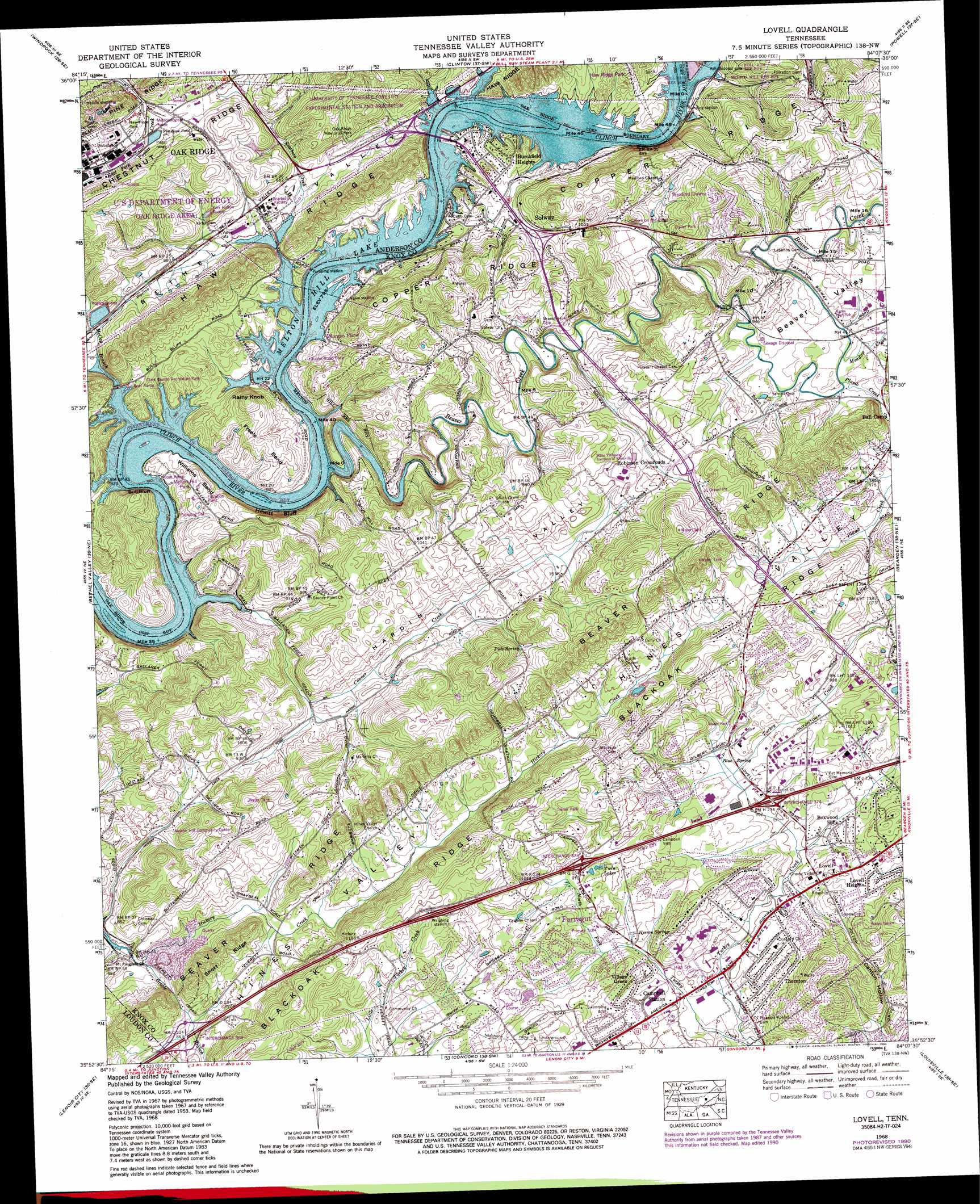
USGS Topo Quad 35084h2 - 1:24,000 scale
| Topo Map Name: | Lovell |
| USGS Topo Quad ID: | 35084h2 |
| Print Size: | ca. 21 1/4" wide x 27" high |
| Southeast Coordinates: | 35.875° N latitude / 84.125° W longitude |
| Map Center Coordinates: | 35.9375° N latitude / 84.1875° W longitude |
| U.S. State: | TN |
| Filename: | o35084h2.jpg |
| Download Map JPG Image: | Lovell topo map 1:24,000 scale |
| Map Type: | Topographic |
| Topo Series: | 7.5´ |
| Map Scale: | 1:24,000 |
| Source of Map Images: | United States Geological Survey (USGS) |
| Alternate Map Versions: |
Lovell TN 1935 Download PDF Buy paper map Lovell TN 1940, updated 1952 Download PDF Buy paper map Lovell TN 1941 Download PDF Buy paper map Lovell TN 1953, updated 1954 Download PDF Buy paper map Lovell TN 1953, updated 1955 Download PDF Buy paper map Lovell TN 1968, updated 1972 Download PDF Buy paper map Lovell TN 1968, updated 1980 Download PDF Buy paper map Lovell TN 1968, updated 1986 Download PDF Buy paper map Lovell TN 1968, updated 1990 Download PDF Buy paper map Lovell TN 2010 Download PDF Buy paper map Lovell TN 2013 Download PDF Buy paper map Lovell TN 2016 Download PDF Buy paper map |
1:24,000 Topo Quads surrounding Lovell
Fork Mountain |
Duncan Flats |
Lake City |
Norris |
Big Ridge Park |
Petros |
Windrock |
Clinton |
Powell |
Fountain City |
Elverton |
Bethel Valley |
Lovell |
Bearden |
Knoxville |
Cave Creek |
Lenoir City |
Concord |
Louisville |
Maryville |
Philadelphia |
Loudon |
Meadow |
Binfield |
Blockhouse |
> Back to 35084e1 at 1:100,000 scale
> Back to 35084a1 at 1:250,000 scale
> Back to U.S. Topo Maps home
Lovell topo map: Gazetteer
Lovell: Bars
Beaver Creek Shoals elevation 242m 793′Cobbs Shoals elevation 242m 793′
Gallahers Shoals elevation 242m 793′
Holts Island Shoals elevation 242m 793′
Jones Shoals elevation 242m 793′
Sneaking Island Shoals elevation 242m 793′
Lovell: Bends
Freels Bend elevation 287m 941′Williams Bend elevation 266m 872′
Lovell: Bridges
Solway Bridge elevation 242m 793′Lovell: Cliffs
Bull Bluff elevation 306m 1003′Hewitt Bluff elevation 273m 895′
Lovell: Crossings
Couch Ford (historical) elevation 242m 793′Gallaher Ferry (historical) elevation 242m 793′
Interchange 369 elevation 266m 872′
Interchange 373 elevation 292m 958′
Interchange 374 elevation 278m 912′
Lee Ford elevation 250m 820′
Scarboroughs Ferry (historical) elevation 242m 793′
Lovell: Islands
Holt Island (historical) elevation 242m 793′Jones Island (historical) elevation 242m 793′
Sneaking Island (historical) elevation 242m 793′
Lovell: Lakes
Twin Lakes elevation 298m 977′Lovell: Parks
Carbide Park elevation 245m 803′Guinn Road Park elevation 265m 869′
Melton Hill Park elevation 267m 875′
Lovell: Populated Places
Amber Meadows elevation 355m 1164′Beaver Creek Estates elevation 327m 1072′
Boxwood Hills elevation 280m 918′
Burchfield Heights elevation 271m 889′
Byrd Chapel elevation 316m 1036′
Farragut elevation 269m 882′
Hickory Woods elevation 307m 1007′
Lovell elevation 297m 974′
Lovell Heights elevation 292m 958′
Lovell Road Mobile Home Park elevation 300m 984′
Plum Creek elevation 319m 1046′
Robinson Crossroads elevation 303m 994′
Scarboro elevation 257m 843′
Solway elevation 269m 882′
Station West elevation 296m 971′
Sweet Briar elevation 304m 997′
Thornton elevation 276m 905′
Twin Springs elevation 290m 951′
Village Green elevation 294m 964′
Volunteer Village elevation 343m 1125′
Wexford Downs elevation 327m 1072′
Wood Creek West elevation 319m 1046′
Woodchase elevation 302m 990′
Woodland Trace elevation 315m 1033′
Lovell: Ridges
Short Ridge elevation 325m 1066′Lovell: Springs
Blue Spring elevation 279m 915′Herron Spring elevation 285m 935′
Pitts Spring elevation 303m 994′
Lovell: Streams
Beaver Creek elevation 242m 793′Bullrun Creek elevation 243m 797′
Canton Creek elevation 272m 892′
Conner Creek elevation 242m 793′
Grable Branch elevation 243m 797′
Hewitt Branch elevation 242m 793′
McCoy Branch elevation 242m 793′
Meadow Creek elevation 284m 931′
Plumb Creek elevation 285m 935′
Scarboro Creek elevation 242m 793′
Lovell: Summits
Rainy Knob elevation 331m 1085′Lovell: Valleys
Beaver Valley elevation 282m 925′Hardin Valley elevation 260m 853′
Lovell digital topo map on disk
Buy this Lovell topo map showing relief, roads, GPS coordinates and other geographical features, as a high-resolution digital map file on DVD: