Ooltewah Topo Map Tennessee
To zoom in, hover over the map of Ooltewah
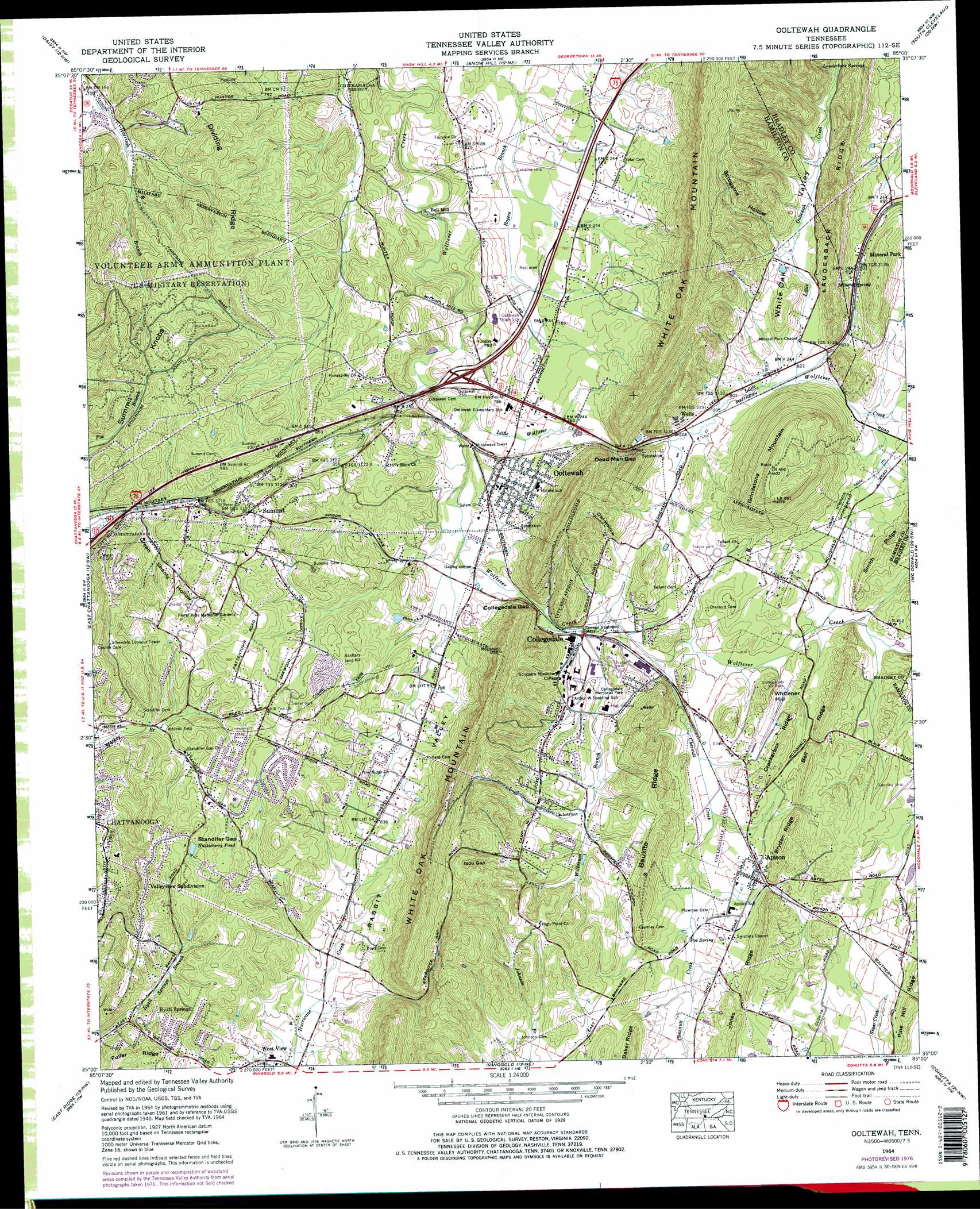
USGS Topo Quad 35085a1 - 1:24,000 scale
| Topo Map Name: | Ooltewah |
| USGS Topo Quad ID: | 35085a1 |
| Print Size: | ca. 21 1/4" wide x 27" high |
| Southeast Coordinates: | 35° N latitude / 85° W longitude |
| Map Center Coordinates: | 35.0625° N latitude / 85.0625° W longitude |
| U.S. State: | TN |
| Filename: | o35085a1.jpg |
| Download Map JPG Image: | Ooltewah topo map 1:24,000 scale |
| Map Type: | Topographic |
| Topo Series: | 7.5´ |
| Map Scale: | 1:24,000 |
| Source of Map Images: | United States Geological Survey (USGS) |
| Alternate Map Versions: |
Ooltewah TN 1935 Download PDF Buy paper map Ooltewah TN 1940, updated 1954 Download PDF Buy paper map Ooltewah TN 1941 Download PDF Buy paper map Ooltewah TN 1964, updated 1966 Download PDF Buy paper map Ooltewah TN 1964, updated 1975 Download PDF Buy paper map Ooltewah TN 1964, updated 1977 Download PDF Buy paper map Ooltewah TN 1964, updated 1977 Download PDF Buy paper map Ooltewah TN 2010 Download PDF Buy paper map Ooltewah TN 2013 Download PDF Buy paper map Ooltewah TN 2016 Download PDF Buy paper map |
1:24,000 Topo Quads surrounding Ooltewah
Henson Gap |
Soddy |
Grasshopper Creek |
Birchwood |
Charleston |
Fairmount |
Daisy |
Snow Hill |
South Cleveland |
East Cleveland |
Chattanooga |
East Chattanooga |
Ooltewah |
Mcdonald |
Felker |
Fort Oglethorpe |
East Ridge |
Ringgold |
Cohutta |
Beaverdale |
Kensington |
Nickajack Gap |
Tunnel Hill |
Dalton North |
Chatsworth |
> Back to 35085a1 at 1:100,000 scale
> Back to 35084a1 at 1:250,000 scale
> Back to U.S. Topo Maps home
Ooltewah topo map: Gazetteer
Ooltewah: Airports
Collegedale Municipal Airport elevation 262m 859′Ooltewah: Crossings
Interchange 11 elevation 231m 757′Ooltewah: Gaps
Collegedale Gap elevation 251m 823′Dead Man Gap elevation 251m 823′
Igou Gap elevation 343m 1125′
Standifer Gap elevation 306m 1003′
Ooltewah: Mines
Smith Prospect elevation 282m 925′Willie Moore Prospect elevation 294m 964′
Ooltewah: Populated Places
Apison elevation 262m 859′Auburn Hills elevation 283m 928′
Collegedale elevation 239m 784′
Green Acres elevation 253m 830′
Grindstone Estates elevation 265m 869′
Maplewood Heights elevation 293m 961′
Mineral Park elevation 274m 898′
Ooltewah elevation 232m 761′
Paradise Mobile Home Park elevation 246m 807′
Ponderosa Pines elevation 283m 928′
Ryall Springs elevation 286m 938′
Summit elevation 274m 898′
Tall Oaks Mobile Home Park elevation 299m 980′
Valleyview Subdivision elevation 337m 1105′
West View elevation 236m 774′
Williamsburg Estates elevation 253m 830′
Yorktown Woods elevation 286m 938′
Ooltewah: Post Offices
Apison Post Office elevation 261m 856′Collegedale Post Office elevation 240m 787′
Ooltewah: Ranges
White Oak Mountain elevation 417m 1368′Ooltewah: Reservoirs
Huckleberry Pond elevation 299m 980′Ooltewah: Ridges
Bauxite Ridge elevation 320m 1049′Bell Ridge elevation 294m 964′
Bryden Ridge elevation 304m 997′
Crackerbox Ridge elevation 301m 987′
Dividing Ridge elevation 295m 967′
Fuller Ridge elevation 297m 974′
Jones Ridge elevation 308m 1010′
Ooltewah: Springs
Lauderback Springs elevation 325m 1066′Mineral Spring elevation 280m 918′
Poe Spring elevation 254m 833′
Ryall Spring elevation 235m 770′
Ooltewah: Streams
Chestnut Creek elevation 238m 780′Little Ooltewah Creek elevation 248m 813′
Little Wolftever Creek elevation 223m 731′
Wilkerson Branch elevation 238m 780′
Ooltewah: Summits
Grindstone Mountain elevation 432m 1417′Summit Knobs elevation 285m 935′
Whitener Hill elevation 280m 918′
Ooltewah: Valleys
Green Shanty Hollow elevation 250m 820′Owl Hollow elevation 258m 846′
Scroggins Hollow elevation 261m 856′
White Oak Valley elevation 250m 820′
Ooltewah digital topo map on disk
Buy this Ooltewah topo map showing relief, roads, GPS coordinates and other geographical features, as a high-resolution digital map file on DVD: