East Chattanooga Topo Map Tennessee
To zoom in, hover over the map of East Chattanooga
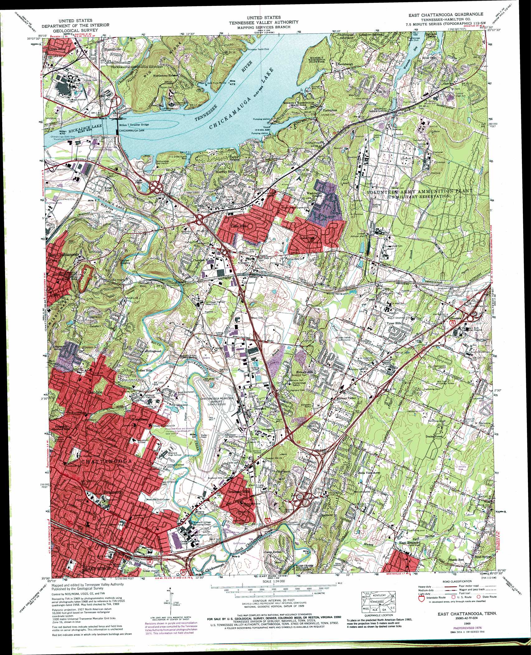
USGS Topo Quad 35085a2 - 1:24,000 scale
| Topo Map Name: | East Chattanooga |
| USGS Topo Quad ID: | 35085a2 |
| Print Size: | ca. 21 1/4" wide x 27" high |
| Southeast Coordinates: | 35° N latitude / 85.125° W longitude |
| Map Center Coordinates: | 35.0625° N latitude / 85.1875° W longitude |
| U.S. State: | TN |
| Filename: | o35085a2.jpg |
| Download Map JPG Image: | East Chattanooga topo map 1:24,000 scale |
| Map Type: | Topographic |
| Topo Series: | 7.5´ |
| Map Scale: | 1:24,000 |
| Source of Map Images: | United States Geological Survey (USGS) |
| Alternate Map Versions: |
East Chattanooga TN 1935 Download PDF Buy paper map East Chattanooga TN 1942 Download PDF Buy paper map East Chattanooga TN 1942, updated 1947 Download PDF Buy paper map East Chattanooga TN 1958, updated 1959 Download PDF Buy paper map East Chattanooga TN 1958, updated 1968 Download PDF Buy paper map East Chattanooga TN 1969, updated 1970 Download PDF Buy paper map East Chattanooga TN 1969, updated 1973 Download PDF Buy paper map East Chattanooga TN 1969, updated 1977 Download PDF Buy paper map East Chattanooga TN 1969, updated 1987 Download PDF Buy paper map East Chattanooga TN 1969, updated 1987 Download PDF Buy paper map East Chattanooga TN 2010 Download PDF Buy paper map East Chattanooga TN 2013 Download PDF Buy paper map East Chattanooga TN 2016 Download PDF Buy paper map |
1:24,000 Topo Quads surrounding East Chattanooga
Daus |
Henson Gap |
Soddy |
Grasshopper Creek |
Birchwood |
Ketner Gap |
Fairmount |
Daisy |
Snow Hill |
South Cleveland |
Wauhatchie |
Chattanooga |
East Chattanooga |
Ooltewah |
Mcdonald |
Hooker |
Fort Oglethorpe |
East Ridge |
Ringgold |
Cohutta |
Durham |
Kensington |
Nickajack Gap |
Tunnel Hill |
Dalton North |
> Back to 35085a1 at 1:100,000 scale
> Back to 35084a1 at 1:250,000 scale
> Back to U.S. Topo Maps home
East Chattanooga topo map: Gazetteer
East Chattanooga: Airports
Lovell Field elevation 204m 669′East Chattanooga: Bars
Chickamauga Shoals elevation 208m 682′East Chattanooga: Bays
Chickamauga Boat Harbor elevation 208m 682′Waconda Bay elevation 208m 682′
East Chattanooga: Bridges
Wilkes T Thrasher Bridge elevation 193m 633′East Chattanooga: Crossings
Interchange 183A elevation 224m 734′Interchange 184 elevation 209m 685′
Interchange 2 and 185 elevation 202m 662′
Interchange 3 elevation 212m 695′
Interchange 4 elevation 212m 695′
Interchange 5 elevation 223m 731′
Interchange 7 elevation 243m 797′
East Chattanooga: Dams
Chickamauga Dam elevation 193m 633′East Chattanooga: Harbors
Gold Point Marina elevation 208m 682′Lakeshore elevation 213m 698′
East Chattanooga: Islands
Chickamauga Island (historical) elevation 208m 682′Friars Island (historical) elevation 193m 633′
East Chattanooga: Lakes
Lake Junior elevation 208m 682′East Chattanooga: Mines
Brannan-Montague Mine elevation 260m 853′Isabella Stewart Mine elevation 259m 849′
Nixon Prospect elevation 267m 875′
East Chattanooga: Parks
Booker T Washington State Park elevation 239m 784′Camp Jordan Park elevation 207m 679′
Chickamauga Dam Day Use Area elevation 213m 698′
Pitner Field elevation 211m 692′
East Chattanooga: Populated Places
Acres of Shade Mobile Home Park elevation 214m 702′Austin Farm elevation 239m 784′
Bartlebaugh elevation 211m 692′
Battery Heights elevation 300m 984′
Bayview elevation 256m 839′
Bella Vista Acres elevation 218m 715′
Brainerd elevation 217m 711′
Brainerd Hills elevation 206m 675′
Brainerd Park elevation 205m 672′
Brentwood elevation 225m 738′
Brookfield elevation 225m 738′
Cambridge Estates elevation 238m 780′
Camp Jordan elevation 247m 810′
Capital Heights elevation 249m 816′
Cherokee Woods elevation 227m 744′
Concord Heights elevation 218m 715′
Creekwood Terrace elevation 217m 711′
Dale Acres elevation 207m 679′
Deerwood Forest elevation 255m 836′
Drake Forest elevation 232m 761′
East Chattanooga elevation 208m 682′
Eastdale elevation 229m 751′
Edgemont Forest elevation 225m 738′
Ela Wada Terrace elevation 215m 705′
Engleton Heights elevation 223m 731′
Forest Hills elevation 216m 708′
Foxwood Heights elevation 254m 833′
Gaylan Heights elevation 256m 839′
Glenmar Hills elevation 252m 826′
Hamillville elevation 207m 679′
Harbor Heights elevation 245m 803′
Harbour Woods elevation 220m 721′
Harrison elevation 234m 767′
Harrison Point elevation 213m 698′
Heritage Hills elevation 232m 761′
Hickory Hills elevation 225m 738′
Hickory Valley elevation 218m 715′
Hillsboro Heights elevation 238m 780′
Holiday Hills elevation 236m 774′
Holy Hills elevation 241m 790′
Indian Hills elevation 212m 695′
Jersey elevation 213m 698′
Kings Point elevation 202m 662′
Lake Hills elevation 251m 823′
Lake Vista elevation 219m 718′
Lakeshor Manor elevation 242m 793′
Lakeshore Estates elevation 239m 784′
Logan Heights elevation 238m 780′
Marimont elevation 253m 830′
Murray Hills elevation 271m 889′
North Brainerd elevation 245m 803′
North Tower Forest elevation 269m 882′
Northshore Estates elevation 244m 800′
Pineoak Heights elevation 222m 728′
Radmoor elevation 213m 698′
Regency Place elevation 248m 813′
Ridgewood Acres elevation 248m 813′
Riggs Trailer Park elevation 206m 675′
River Oaks elevation 223m 731′
Rollingwood elevation 213m 698′
Royal Oaks elevation 219m 718′
Shady Rest elevation 231m 757′
Shallowford Hills elevation 231m 757′
Shawnee Park elevation 211m 692′
Shepherd elevation 209m 685′
Silverdale elevation 233m 764′
South Brainerd elevation 210m 688′
Talley Place elevation 206m 675′
Theresa Heights elevation 224m 734′
Turkeyfoot elevation 221m 725′
Tyner elevation 218m 715′
Tyner Hills elevation 223m 731′
Vista Hills elevation 235m 770′
Washington Heights elevation 237m 777′
Washington Hills elevation 258m 846′
Washington Place elevation 241m 790′
Whispering Pines Mobile Home Park elevation 204m 669′
Woodmore elevation 209m 685′
East Chattanooga: Post Offices
Brainerd Post Office elevation 207m 679′Chickamauga Post Office elevation 208m 682′
Harrison Post Office elevation 227m 744′
Tyner Post Office elevation 214m 702′
East Chattanooga: Reservoirs
Chickamauga Lake elevation 193m 633′East Chattanooga: Streams
Friar Branch elevation 197m 646′North Chickamauga Creek elevation 193m 633′
Poe Branch elevation 207m 679′
Ryall Springs Branch elevation 208m 682′
Spring Creek elevation 201m 659′
Spring Creek elevation 204m 669′
West Chickamauga Creek elevation 200m 656′
West Chickamauga Creek elevation 201m 659′
East Chattanooga digital topo map on disk
Buy this East Chattanooga topo map showing relief, roads, GPS coordinates and other geographical features, as a high-resolution digital map file on DVD: