Chattanooga Topo Map Tennessee
To zoom in, hover over the map of Chattanooga
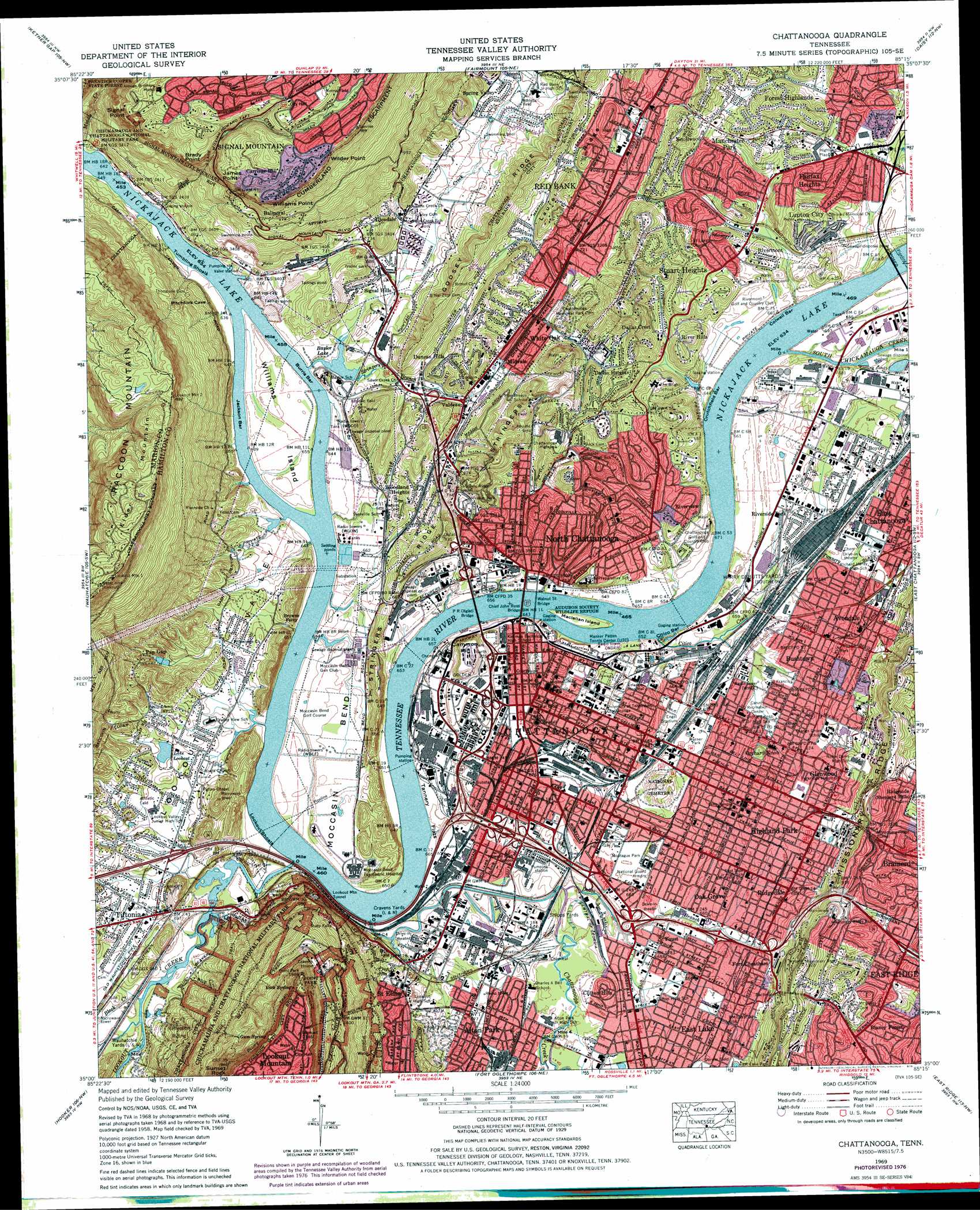
USGS Topo Quad 35085a3 - 1:24,000 scale
| Topo Map Name: | Chattanooga |
| USGS Topo Quad ID: | 35085a3 |
| Print Size: | ca. 21 1/4" wide x 27" high |
| Southeast Coordinates: | 35° N latitude / 85.25° W longitude |
| Map Center Coordinates: | 35.0625° N latitude / 85.3125° W longitude |
| U.S. State: | TN |
| Filename: | o35085a3.jpg |
| Download Map JPG Image: | Chattanooga topo map 1:24,000 scale |
| Map Type: | Topographic |
| Topo Series: | 7.5´ |
| Map Scale: | 1:24,000 |
| Source of Map Images: | United States Geological Survey (USGS) |
| Alternate Map Versions: |
Chattanooga TN 1936 Download PDF Buy paper map Chattanooga TN 1940 Download PDF Buy paper map Chattanooga TN 1940, updated 1956 Download PDF Buy paper map Chattanooga TN 1941 Download PDF Buy paper map Chattanooga TN 1941 Download PDF Buy paper map Chattanooga TN 1941, updated 1947 Download PDF Buy paper map Chattanooga TN 1941, updated 1947 Download PDF Buy paper map Chattanooga TN 1958, updated 1959 Download PDF Buy paper map Chattanooga TN 1958, updated 1960 Download PDF Buy paper map Chattanooga TN 1958, updated 1960 Download PDF Buy paper map Chattanooga TN 1969, updated 1969 Download PDF Buy paper map Chattanooga TN 1969, updated 1969 Download PDF Buy paper map Chattanooga TN 1969, updated 1975 Download PDF Buy paper map Chattanooga TN 1969, updated 1978 Download PDF Buy paper map Chattanooga TN 1969, updated 1987 Download PDF Buy paper map Chattanooga TN 2010 Download PDF Buy paper map Chattanooga TN 2013 Download PDF Buy paper map Chattanooga TN 2016 Download PDF Buy paper map |
1:24,000 Topo Quads surrounding Chattanooga
Palmer |
Daus |
Henson Gap |
Soddy |
Grasshopper Creek |
Whitwell |
Ketner Gap |
Fairmount |
Daisy |
Snow Hill |
Sequatchie |
Wauhatchie |
Chattanooga |
East Chattanooga |
Ooltewah |
New Home |
Hooker |
Fort Oglethorpe |
East Ridge |
Ringgold |
Trenton |
Durham |
Kensington |
Nickajack Gap |
Tunnel Hill |
> Back to 35085a1 at 1:100,000 scale
> Back to 35084a1 at 1:250,000 scale
> Back to U.S. Topo Maps home
Chattanooga topo map: Gazetteer
Chattanooga: Airports
Lookout Mountain Airport elevation 198m 649′Chattanooga: Areas
Blue Suck elevation 193m 633′Chattanooga: Bars
Burris Bar elevation 193m 633′Chattanooga Shoals elevation 193m 633′
Citico Bar elevation 193m 633′
Colwell Bar elevation 193m 633′
Crutchfield Bar elevation 193m 633′
Jackson Bar elevation 193m 633′
Lookout Shoals elevation 193m 633′
Rolling Mill Shoals elevation 193m 633′
Ross First Shoals elevation 193m 633′
Ross Second Island Shoals elevation 193m 633′
Ross Towhead elevation 193m 633′
South Chickamauga Shoals elevation 193m 633′
Tumbling Shoals elevation 195m 639′
Chattanooga: Bends
Moccasin Bend elevation 203m 666′Chattanooga: Bridges
Chief John Ross Bridge elevation 193m 633′P R Olgiati Bridge elevation 193m 633′
Walnut Street Bridge elevation 193m 633′
Chattanooga: Capes
Point Park elevation 615m 2017′Chattanooga: Cliffs
Atlanuwa elevation 218m 715′Brady Point elevation 491m 1610′
James Point elevation 458m 1502′
Signal Point elevation 507m 1663′
Wilder Point elevation 498m 1633′
Williams Point elevation 494m 1620′
Chattanooga: Crossings
Browns Ferry elevation 195m 639′Interchange 1 elevation 211m 692′
Interchange 175 elevation 203m 666′
Interchange 178 elevation 205m 672′
Interchange 179 elevation 203m 666′
Interchange 180 elevation 199m 652′
Interchange 180A elevation 207m 679′
Interchange 181 elevation 201m 659′
Interchange 181A elevation 222m 728′
Interchange 183 elevation 236m 774′
Interchange 1C elevation 211m 692′
Ross Ferry (historical) elevation 193m 633′
Chattanooga: Dams
Lake Lookout Dam elevation 209m 685′Pan Gap Dam elevation 226m 741′
Chattanooga: Flats
Tannery Flats elevation 193m 633′Chattanooga: Gaps
Golden Gateway elevation 221m 725′Chattanooga: Islands
Maclellan Island elevation 198m 649′Ross Second Island (historical) elevation 193m 633′
Williams Island elevation 201m 659′
Chattanooga: Lakes
Baylor Lake elevation 193m 633′McCallie Lake elevation 219m 718′
Chattanooga: Mines
Bennett Mine elevation 292m 958′Hornville Mine elevation 262m 859′
McCallie Tunnel Prospect elevation 277m 908′
Wilcox Prospect elevation 277m 908′
Chattanooga: Parks
Audubon Society Wildlife Refuge elevation 196m 643′Boynton Park elevation 258m 846′
Coolidge Park elevation 504m 1653′
Darwin Field elevation 207m 679′
East Lake Park elevation 219m 718′
Engel Stadium elevation 201m 659′
Fountain Square elevation 221m 725′
Franklin Field (historical) elevation 208m 682′
Green Gorge Park elevation 511m 1676′
Jackson Park elevation 206m 675′
Lincoln Park elevation 203m 666′
Miller Park elevation 207m 679′
Montague Park elevation 198m 649′
Norris Field elevation 541m 1774′
Orchard Knob Reservation elevation 202m 662′
Ross Landing City Park elevation 202m 662′
South Stadium elevation 222m 728′
Warner Park elevation 203m 666′
Williams Island State Archaeological Park elevation 201m 659′
Chattanooga: Pillars
Sunset Rock elevation 549m 1801′Chattanooga: Populated Places
Alton Park elevation 211m 692′Andrea Heights elevation 219m 718′
Armstrong Trailer Park elevation 209m 685′
Avondale elevation 212m 695′
Balmoral elevation 387m 1269′
Blaney Forest elevation 253m 830′
Boyce elevation 207m 679′
Bushtown elevation 200m 656′
Carriage Hill elevation 505m 1656′
Chattanooga elevation 206m 675′
Claremont elevation 266m 872′
Clarks Mobile Home Park elevation 204m 669′
Clifton Hills elevation 207m 679′
Colonial Village elevation 242m 793′
Dallas Crest elevation 248m 813′
Dallas Heights elevation 243m 797′
Duncan Hills elevation 245m 803′
East Lake elevation 211m 692′
East Ridge elevation 237m 777′
Easton Terrace elevation 222m 728′
Elder Mountain elevation 562m 1843′
Fairfax Heights elevation 250m 820′
Fairhills elevation 212m 695′
Forest Highlands elevation 277m 908′
Fort Cheatham elevation 212m 695′
Fountain Village elevation 231m 757′
Foust elevation 201m 659′
Glendale elevation 235m 770′
Glenwood elevation 204m 669′
Hampton Heights elevation 225m 738′
Highland Park elevation 206m 675′
Jones Mobile Home Park elevation 209m 685′
Knollwood elevation 278m 912′
Lake Village elevation 202m 662′
Lockwood Heights elevation 223m 731′
Lupton City elevation 239m 784′
Manchester Park elevation 253m 830′
Midvale elevation 206m 675′
Mountain Ridge elevation 241m 790′
North Chattanooga elevation 201m 659′
Oak Grove elevation 200m 656′
Oakhurst elevation 277m 908′
Old Farm elevation 221m 725′
Orchard Knob elevation 205m 672′
Palisades elevation 534m 1751′
Pan Gap elevation 238m 780′
Pineville elevation 201m 659′
Poindexter Heights elevation 277m 908′
Quail Hollow elevation 217m 711′
Red Bank elevation 220m 721′
Ridgedale elevation 209m 685′
Ridgeside elevation 258m 846′
River Hills elevation 243m 797′
Rivermont elevation 230m 754′
Riverside Park elevation 208m 682′
Riverview elevation 226m 741′
Ruby Falls elevation 334m 1095′
Signal Hills elevation 209m 685′
Signal Mountain elevation 519m 1702′
Spring Valley elevation 221m 725′
Stuart Heights elevation 263m 862′
Tiftonia elevation 203m 666′
Tuckegee (historical) elevation 204m 669′
Valdeau elevation 207m 679′
Valley Village elevation 200m 656′
White Oak elevation 208m 682′
Woodland Heights elevation 231m 757′
Chattanooga: Post Offices
Downtown Station Chattanooga Post Office elevation 208m 682′East Chattanooga Post Office elevation 205m 672′
East Lake Post Office elevation 210m 688′
Highland Park Post Office elevation 207m 679′
Red Bank Post Office elevation 224m 734′
Signal Mountain Post Office elevation 515m 1689′
South Station Chattanooga Post Office elevation 207m 679′
Chattanooga: Reservoirs
Lake Lookout elevation 209m 685′Pan Gap Lake elevation 226m 741′
Chattanooga: Ridges
Godsey Ridge elevation 299m 980′Laurel Ridge elevation 259m 849′
Stringers Ridge elevation 279m 915′
Chattanooga: Springs
Gum Spring elevation 444m 1456′Rock Spring elevation 570m 1870′
Chattanooga: Streams
Black Creek elevation 195m 639′Chattanooga Creek elevation 195m 639′
Chattanooga Creek elevation 195m 639′
Citico Creek elevation 200m 656′
Dobbs Branch elevation 195m 639′
Lookout Creek elevation 195m 639′
Middle Creek elevation 196m 643′
Mountain Creek elevation 193m 633′
Shoal Creek elevation 193m 633′
South Chickamauga Creek elevation 193m 633′
Stringers Branch elevation 193m 633′
Tannery Branch elevation 201m 659′
Chattanooga: Summits
Cameron Hill elevation 259m 849′Lookout Mountain elevation 654m 2145′
Signal Mountain elevation 319m 1046′
Chattanooga: Trails
Hardy Trail elevation 493m 1617′Lookout Creek Trail elevation 208m 682′
Skyuka Trail elevation 310m 1017′
Chattanooga: Tunnels
Bachman Tubes elevation 313m 1026′Lookout Mountain Tunnel elevation 245m 803′
Missionary Ridge Tunnel elevation 284m 931′
Stringers Ridge Tunnel elevation 264m 866′
Wilcox Tunnel elevation 288m 944′
Chattanooga: Valleys
Chattanooga Valley elevation 202m 662′Lookout Valley elevation 202m 662′
Chattanooga digital topo map on disk
Buy this Chattanooga topo map showing relief, roads, GPS coordinates and other geographical features, as a high-resolution digital map file on DVD: