Sequatchie Topo Map Tennessee
To zoom in, hover over the map of Sequatchie
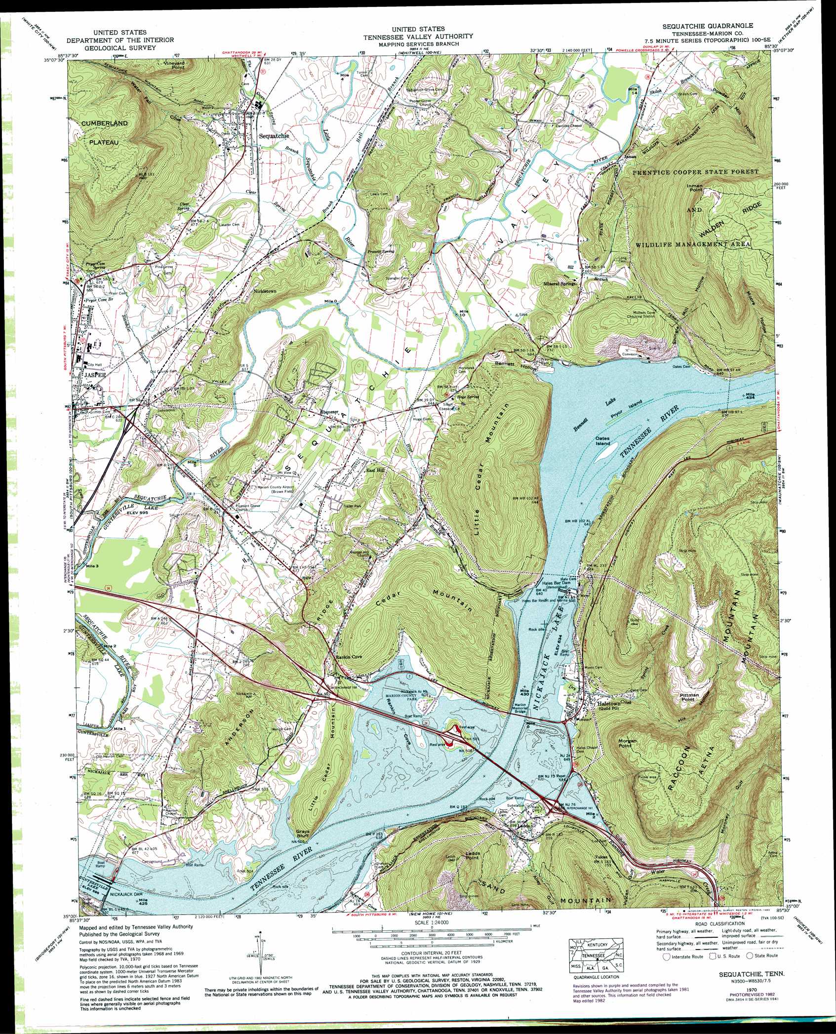
USGS Topo Quad 35085a5 - 1:24,000 scale
| Topo Map Name: | Sequatchie |
| USGS Topo Quad ID: | 35085a5 |
| Print Size: | ca. 21 1/4" wide x 27" high |
| Southeast Coordinates: | 35° N latitude / 85.5° W longitude |
| Map Center Coordinates: | 35.0625° N latitude / 85.5625° W longitude |
| U.S. State: | TN |
| Filename: | o35085a5.jpg |
| Download Map JPG Image: | Sequatchie topo map 1:24,000 scale |
| Map Type: | Topographic |
| Topo Series: | 7.5´ |
| Map Scale: | 1:24,000 |
| Source of Map Images: | United States Geological Survey (USGS) |
| Alternate Map Versions: |
Sequatchie TN 1936 Download PDF Buy paper map Sequatchie TN 1942 Download PDF Buy paper map Sequatchie TN 1942, updated 1957 Download PDF Buy paper map Sequatchie TN 1943, updated 1946 Download PDF Buy paper map Sequatchie TN 1970, updated 1972 Download PDF Buy paper map Sequatchie TN 1970, updated 1983 Download PDF Buy paper map Sequatchie TN 2010 Download PDF Buy paper map Sequatchie TN 2013 Download PDF Buy paper map Sequatchie TN 2016 Download PDF Buy paper map |
1:24,000 Topo Quads surrounding Sequatchie
Burrow Cove |
Tracy City |
Palmer |
Daus |
Henson Gap |
Monteagle |
White City |
Whitwell |
Ketner Gap |
Fairmount |
Orme |
South Pittsburg |
Sequatchie |
Wauhatchie |
Chattanooga |
Doran Cove |
Bridgeport |
New Home |
Hooker |
Fort Oglethorpe |
Stevenson |
Flat Rock |
Trenton |
Durham |
Kensington |
> Back to 35085a1 at 1:100,000 scale
> Back to 35084a1 at 1:250,000 scale
> Back to U.S. Topo Maps home
Sequatchie topo map: Gazetteer
Sequatchie: Airports
Marion County Airport-Brown Field elevation 196m 643′Sequatchie: Bays
Rankin Cove elevation 193m 633′Sequatchie: Bridges
Marion Memorial Bridge elevation 193m 633′Sequatchie: Capes
Inman Point elevation 618m 2027′Ladds Point elevation 462m 1515′
Morgan Point elevation 422m 1384′
Pittman Point elevation 420m 1377′
Vineyard Point elevation 477m 1564′
Sequatchie: Cliffs
Grays Bluff elevation 214m 702′Sequatchie: Crossings
Gardenhires Ferry (historical) elevation 193m 633′Halls Ferry (historical) elevation 193m 633′
Interchange 158 elevation 219m 718′
Interchange 161 elevation 199m 652′
Rankin Ferry (historical) elevation 193m 633′
Riggles Ferry (historical) elevation 193m 633′
Sequatchie: Dams
Nickajack Dam elevation 181m 593′Sequatchie: Gaps
The Narrows elevation 193m 633′Sequatchie: Islands
Oates Island elevation 195m 639′Pryor Island elevation 194m 636′
Sequatchie: Lakes
Bennett Lake elevation 193m 633′Sequatchie: Mines
Bennetts Lake Quarry elevation 235m 770′Inman Mine elevation 234m 767′
Sequatchie: Parks
Blowing Spring Park elevation 195m 639′Jasper City Park elevation 193m 633′
Marion County Park elevation 195m 639′
Running Water Public Use Area elevation 195m 639′
Sequatchie: Populated Places
East Hill elevation 198m 649′Ebenezer elevation 191m 626′
Haletown elevation 195m 639′
Inman elevation 198m 649′
Ladds elevation 211m 692′
Mineral Springs elevation 207m 679′
Nickletown elevation 201m 659′
Rankin Cove elevation 232m 761′
Sequatchie elevation 200m 656′
Vulcan elevation 231m 757′
Sequatchie: Post Offices
Sequatchie Post Office elevation 200m 656′Sequatchie: Reservoirs
Nickajack Lake elevation 181m 593′Sequatchie: Ridges
Anderson Ridge elevation 299m 980′Sequatchie: Springs
Blowing Spring elevation 195m 639′Clear Spring elevation 202m 662′
Francis Spring elevation 187m 613′
Hoge Spring elevation 206m 675′
Myers Spring (historical) elevation 194m 636′
Pryor Cave Spring elevation 201m 659′
Roope Spring elevation 195m 639′
Sequatchie: Streams
Alley Gulf Branch elevation 193m 633′Clear Spring Branch elevation 186m 610′
Dry Creek elevation 193m 633′
Graham Cove Branch elevation 195m 639′
Hall Branch elevation 188m 616′
Hix Hollow Branch elevation 225m 738′
Hoge Branch elevation 185m 606′
Little Sequatchie River elevation 185m 606′
Moroney Gulf Branch elevation 209m 685′
Owen Spring Branch elevation 189m 620′
Peck Branch elevation 187m 613′
Pryor Cove Branch elevation 196m 643′
Running Water Creek elevation 193m 633′
Shiloh Branch elevation 189m 620′
Spring Creek elevation 224m 734′
The Lagoon elevation 193m 633′
Town Creek elevation 183m 600′
Sequatchie: Summits
Aetna Mountain elevation 491m 1610′Cedar Mountain elevation 354m 1161′
Little Cedar Mountain elevation 441m 1446′
Little Cedar Mountain elevation 275m 902′
Raccoon Mountain elevation 563m 1847′
Sequatchie: Valleys
Alley Gulf elevation 213m 698′Bennett Hollow elevation 193m 633′
Graham Cove elevation 195m 639′
Moore Hollow elevation 204m 669′
Moroney Gulf elevation 213m 698′
Powder Mill Hollow elevation 194m 636′
Sequatchie Valley elevation 196m 643′
Shingle Mill Hollow elevation 195m 639′
Spring Gulf elevation 238m 780′
Vulcan Gulf elevation 206m 675′
Water Fall Cove elevation 215m 705′
Sequatchie digital topo map on disk
Buy this Sequatchie topo map showing relief, roads, GPS coordinates and other geographical features, as a high-resolution digital map file on DVD: