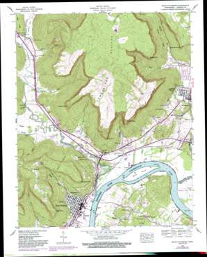
South Pittsburg Topo Map Tennessee
To zoom in, hover over the map of South Pittsburg
USGS Topo Quad 35085a6 - 1:24,000 scale
| Topo Map Name: | South Pittsburg |
| USGS Topo Quad ID: | 35085a6 |
| Print Size: | ca. 21 1/4" wide x 27" high |
| Southeast Coordinates: | 35° N latitude / 85.625° W longitude |
| Map Center Coordinates: | 35.0625° N latitude / 85.6875° W longitude |
| U.S. State: | TN |
| Filename: | o35085a6.jpg |
| Download Map JPG Image: | South Pittsburg topo map 1:24,000 scale |
| Map Type: | Topographic |
| Topo Series: | 7.5´ |
| Map Scale: | 1:24,000 |
| Source of Map Images: | United States Geological Survey (USGS) |
| Alternate Map Versions: |
South Pittsburg TN 1936 Download PDF Buy paper map South Pittsburg TN 1942, updated 1955 Download PDF Buy paper map South Pittsburg TN 1942, updated 1955 Download PDF Buy paper map South Pittsburg TN 1942, updated 1966 Download PDF Buy paper map South Pittsburg TN 1942, updated 1970 Download PDF Buy paper map South Pittsburg TN 1942, updated 1974 Download PDF Buy paper map South Pittsburg TN 1942, updated 1983 Download PDF Buy paper map South Pittsburg TN 1943, updated 1946 Download PDF Buy paper map South Pittsburg TN 1943, updated 1946 Download PDF Buy paper map South Pittsburg TN 2010 Download PDF Buy paper map South Pittsburg TN 2013 Download PDF Buy paper map South Pittsburg TN 2016 Download PDF Buy paper map |
1:24,000 Topo Quads surrounding South Pittsburg
> Back to 35085a1 at 1:100,000 scale
> Back to 35084a1 at 1:250,000 scale
> Back to U.S. Topo Maps home
South Pittsburg topo map: Gazetteer
South Pittsburg: Bars
Burns Bar elevation 181m 593′South Pittsburg: Bridges
Pat Layne Memorial Bridge elevation 181m 593′Shelby Rhinehart Bridge elevation 181m 593′
South Pittsburg: Capes
Castle Rock Point elevation 482m 1581′Kimball Point elevation 505m 1656′
King Point elevation 426m 1397′
Lodge Point elevation 490m 1607′
Middle Point elevation 520m 1706′
Roberts Point elevation 509m 1669′
Whitacre Point elevation 507m 1663′
South Pittsburg: Cliffs
Fullerton Bluff elevation 513m 1683′South Pittsburg: Crossings
Alleys Ferry (historical) elevation 181m 593′Fish Trap Ford elevation 181m 593′
Grahams Ferry (historical) elevation 181m 593′
Interchange 152 elevation 189m 620′
Interchange 155 elevation 223m 731′
Ketchalls Ford elevation 181m 593′
Kings Ford elevation 183m 600′
Lowrys Ferry (historical) elevation 181m 593′
South Pittsburg Ferry (historical) elevation 181m 593′
South Pittsburg: Islands
Burns Island elevation 187m 613′South Pittsburg: Mines
Ketchall Quarry elevation 207m 679′Richard City Quarry elevation 240m 787′
South Pittsburg: Parks
Beene Stadium elevation 191m 626′Loyd Park elevation 207m 679′
South Pittsburg Historic District elevation 196m 643′
South Pittsburg Municipal Park elevation 187m 613′
South Pittsburg: Populated Places
Dixie Lee elevation 194m 636′Glover Hill elevation 214m 702′
Hamburg elevation 187m 613′
Jasper elevation 191m 626′
Ketchall (historical) elevation 191m 626′
Kimball elevation 207m 679′
New Hope elevation 218m 715′
Pinhook elevation 192m 629′
Raulstontown elevation 283m 928′
Smithtown elevation 204m 669′
South Pittsburg elevation 192m 629′
Sweetens Cove elevation 190m 623′
South Pittsburg: Post Offices
South Pittsburg Post Office elevation 194m 636′South Pittsburg: Ridges
Cedar Ridge elevation 290m 951′South Pittsburg: Springs
Bible Spring elevation 197m 646′Blue Spring elevation 196m 643′
Druin Spring elevation 201m 659′
Fish Trap Spring elevation 181m 593′
Gilliam Spring elevation 201m 659′
Hightower Spring elevation 188m 616′
King Spring elevation 202m 662′
South Pittsburg: Streams
Battle Creek elevation 181m 593′Big Fiery Gizzard Creek elevation 187m 613′
Glover Branch elevation 181m 593′
Graham Branch elevation 183m 600′
Kelly Cove Branch elevation 182m 597′
Kimball Cove Branch elevation 181m 593′
Raulston Branch elevation 184m 603′
Sequatchie River elevation 182m 597′
Standifer Branch elevation 183m 600′
Sweden Creek elevation 181m 593′
West Fork Pryor Cove Branch elevation 216m 708′
South Pittsburg: Summits
Clute Hill elevation 208m 682′South Pittsburg: Valleys
Beene Cove elevation 217m 711′Blevins Hollow elevation 189m 620′
Gilliam Cove elevation 205m 672′
Gizzard Cove elevation 192m 629′
Happy Hollow elevation 219m 718′
Hise Cove elevation 200m 656′
Kelly Cove elevation 214m 702′
Kimball Cove elevation 226m 741′
Pryor Cove elevation 225m 738′
Raulstons Cove elevation 194m 636′
Sweetens Cove elevation 183m 600′
South Pittsburg digital topo map on disk
Buy this South Pittsburg topo map showing relief, roads, GPS coordinates and other geographical features, as a high-resolution digital map file on DVD:


