Snow Hill Topo Map Tennessee
To zoom in, hover over the map of Snow Hill
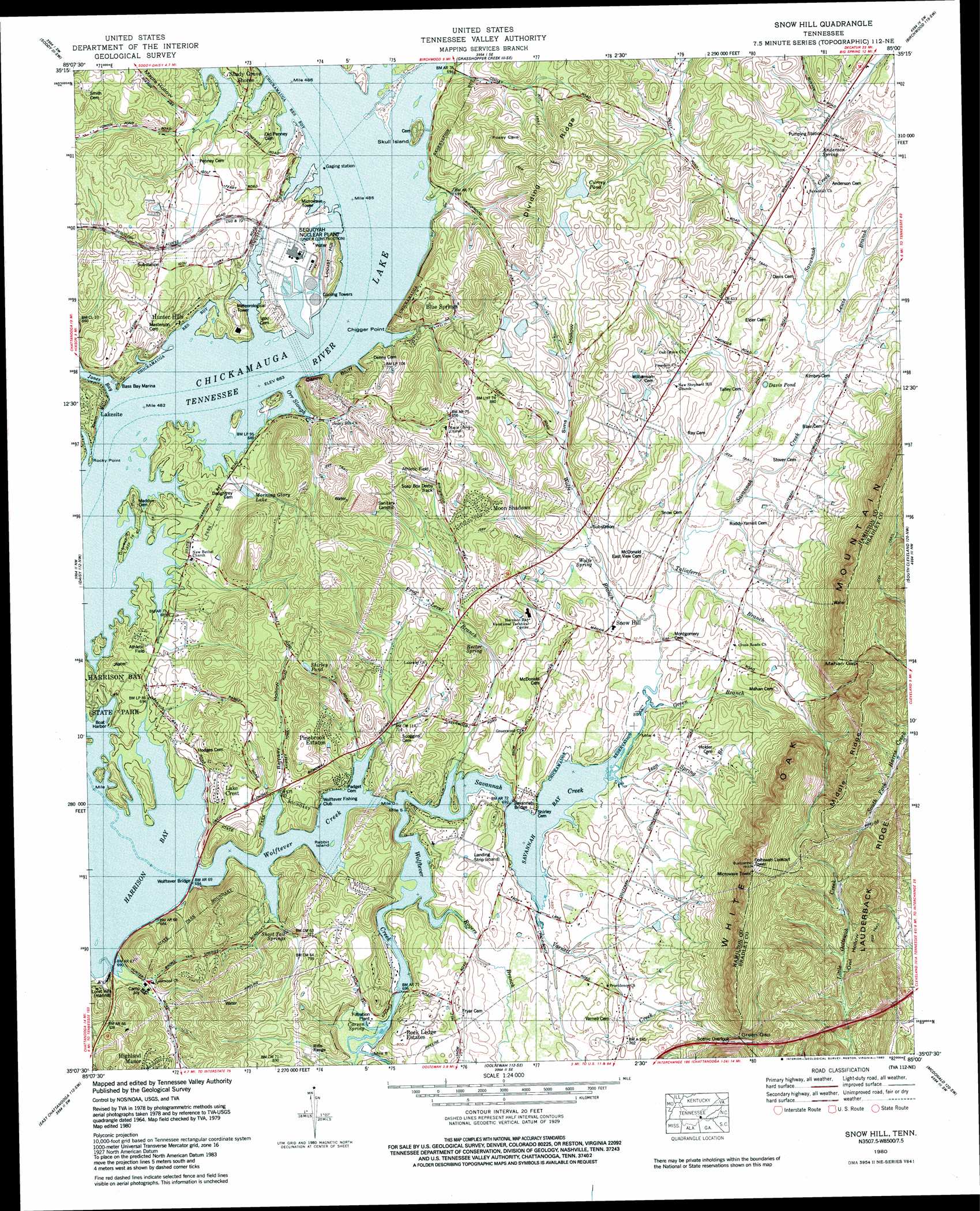
USGS Topo Quad 35085b1 - 1:24,000 scale
| Topo Map Name: | Snow Hill |
| USGS Topo Quad ID: | 35085b1 |
| Print Size: | ca. 21 1/4" wide x 27" high |
| Southeast Coordinates: | 35.125° N latitude / 85° W longitude |
| Map Center Coordinates: | 35.1875° N latitude / 85.0625° W longitude |
| U.S. State: | TN |
| Filename: | o35085b1.jpg |
| Download Map JPG Image: | Snow Hill topo map 1:24,000 scale |
| Map Type: | Topographic |
| Topo Series: | 7.5´ |
| Map Scale: | 1:24,000 |
| Source of Map Images: | United States Geological Survey (USGS) |
| Alternate Map Versions: |
Snow Hill TN 1935 Download PDF Buy paper map Snow Hill TN 1942, updated 1954 Download PDF Buy paper map Snow Hill TN 1943 Download PDF Buy paper map Snow Hill TN 1943 Download PDF Buy paper map Snow Hill TN 1964, updated 1966 Download PDF Buy paper map Snow Hill TN 1964, updated 1975 Download PDF Buy paper map Snow Hill TN 1980, updated 1980 Download PDF Buy paper map Snow Hill TN 1980, updated 1980 Download PDF Buy paper map Snow Hill TN 2010 Download PDF Buy paper map Snow Hill TN 2013 Download PDF Buy paper map Snow Hill TN 2016 Download PDF Buy paper map |
1:24,000 Topo Quads surrounding Snow Hill
Mount Airy |
Brayton |
Graysville |
Big Spring |
Goodfield |
Henson Gap |
Soddy |
Grasshopper Creek |
Birchwood |
Charleston |
Fairmount |
Daisy |
Snow Hill |
South Cleveland |
East Cleveland |
Chattanooga |
East Chattanooga |
Ooltewah |
Mcdonald |
Felker |
Fort Oglethorpe |
East Ridge |
Ringgold |
Cohutta |
Beaverdale |
> Back to 35085a1 at 1:100,000 scale
> Back to 35084a1 at 1:250,000 scale
> Back to U.S. Topo Maps home
Snow Hill topo map: Gazetteer
Snow Hill: Bays
Blue Springs Slough elevation 208m 682′Hide Out Slough elevation 208m 682′
Jones Bay elevation 208m 682′
Savannah Bay elevation 208m 682′
Snow Hill: Bridges
Savannah Bridge elevation 209m 685′Wolftever Bridge elevation 208m 682′
Snow Hill: Capes
Chigger Point elevation 224m 734′Graveyard Point elevation 210m 688′
Rocky Point elevation 215m 705′
Snow Hill: Cliffs
Denny Bluff elevation 213m 698′Gann Bluff elevation 213m 698′
Snow Hill: Crossings
Igous Ferry (historical) elevation 208m 682′Snow Hill: Gaps
Green Gap elevation 273m 895′Mahan Gap elevation 352m 1154′
Snow Hill: Guts
Orr Slough elevation 208m 682′Snow Hill: Harbors
Bass Bay Marina elevation 208m 682′Snow Hill: Islands
Rabbit Island elevation 209m 685′Skull Island elevation 220m 721′
Snow Hill: Lakes
Davis Pond elevation 225m 738′Shirley Pond elevation 259m 849′
Snow Hill: Parks
Harrison Bay State Park elevation 212m 695′Skull Island Recreation Area elevation 220m 721′
Snow Hill: Populated Places
Blue Springs elevation 241m 790′Highland Manor elevation 288m 944′
Lake Crest elevation 228m 748′
Moon Shadows elevation 255m 836′
Morgan Estates elevation 244m 800′
Pinebrook Estates elevation 251m 823′
Rock Ledge Estates elevation 243m 797′
Savannah Bay elevation 213m 698′
Savannah Hills elevation 214m 702′
Savannah Peninsula elevation 211m 692′
Snow Hill elevation 217m 711′
Summer Haven elevation 223m 731′
Snow Hill: Reservoirs
Currey Pond elevation 271m 889′Morning Glory Lake elevation 213m 698′
Snow Hill: Ridges
Lauderback Ridge elevation 380m 1246′Middle Ridge elevation 387m 1269′
Snow Hill: Springs
Anderson Spring elevation 223m 731′Blue Spring elevation 208m 682′
Carson Spring elevation 210m 688′
Rector Spring elevation 226m 741′
Short Tail Springs elevation 220m 721′
Wolfe Spring elevation 213m 698′
Snow Hill: Streams
Blue Spring Creek elevation 208m 682′Frog Level Branch elevation 208m 682′
Green Branch elevation 209m 685′
Ison Spring Branch elevation 209m 685′
Lewis Branch elevation 219m 718′
Long Savannah Creek elevation 208m 682′
Rogers Branch elevation 208m 682′
Runyan Spring Branch elevation 231m 757′
Taliaferro Branch elevation 213m 698′
Varnell Creek elevation 209m 685′
Wolfe Branch elevation 210m 688′
Snow Hill: Summits
Locust Hill elevation 232m 761′Snow Hill: Valleys
Maple Hollow elevation 213m 698′Owl Hollow elevation 300m 984′
Ramsey Hollow elevation 208m 682′
Sims Hollow elevation 216m 708′
Snow Hill digital topo map on disk
Buy this Snow Hill topo map showing relief, roads, GPS coordinates and other geographical features, as a high-resolution digital map file on DVD: