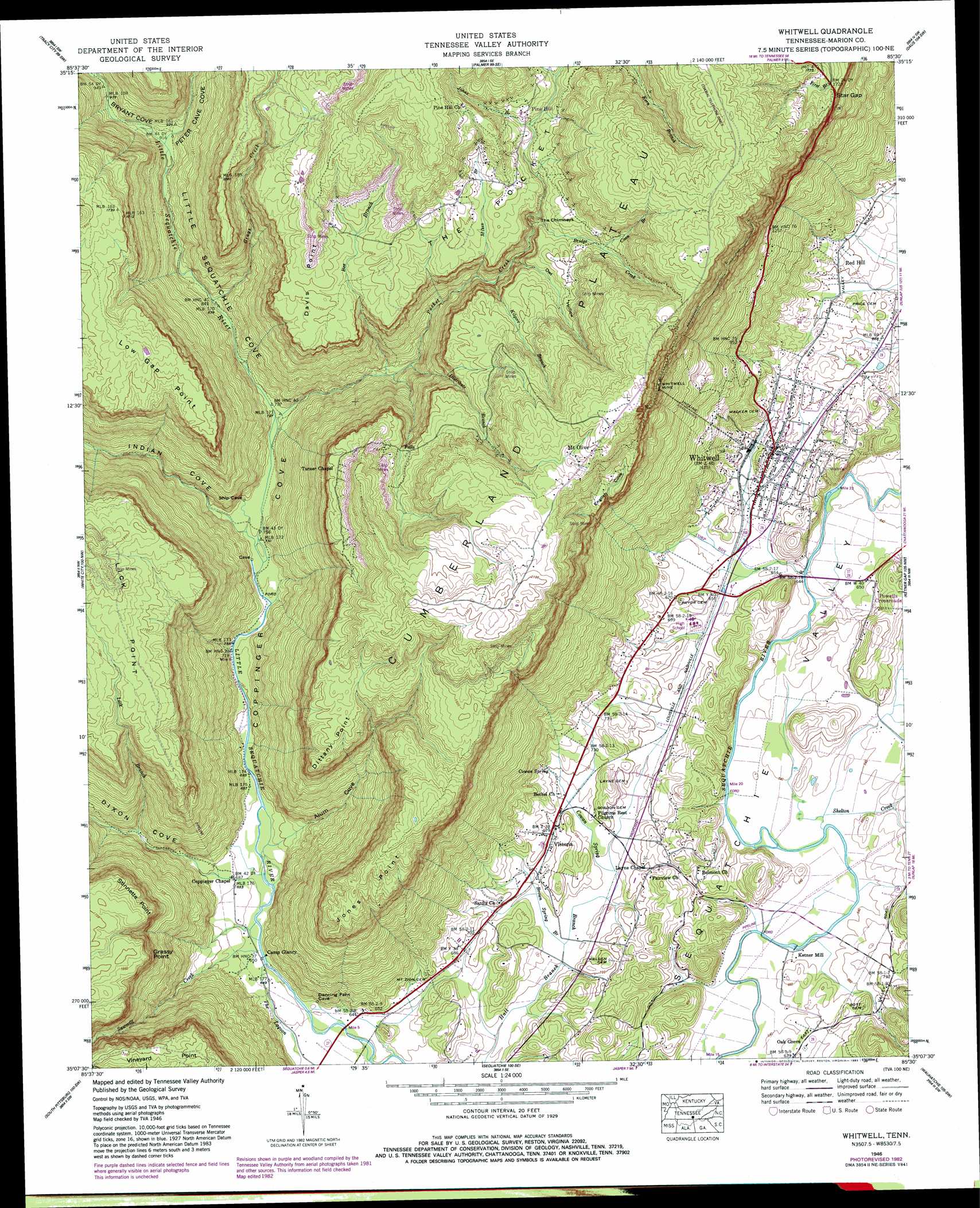
Whitwell Topo Map Tennessee
To zoom in, hover over the map of Whitwell
USGS Topo Quad 35085b5 - 1:24,000 scale
| Topo Map Name: | Whitwell |
| USGS Topo Quad ID: | 35085b5 |
| Print Size: | ca. 21 1/4" wide x 27" high |
| Southeast Coordinates: | 35.125° N latitude / 85.5° W longitude |
| Map Center Coordinates: | 35.1875° N latitude / 85.5625° W longitude |
| U.S. State: | TN |
| Filename: | o35085b5.jpg |
| Download Map JPG Image: | Whitwell topo map 1:24,000 scale |
| Map Type: | Topographic |
| Topo Series: | 7.5´ |
| Map Scale: | 1:24,000 |
| Source of Map Images: | United States Geological Survey (USGS) |
| Alternate Map Versions: |
Whitwell TN 1936 Download PDF Buy paper map Whitwell TN 1946, updated 1964 Download PDF Buy paper map Whitwell TN 1946, updated 1966 Download PDF Buy paper map Whitwell TN 1946, updated 1973 Download PDF Buy paper map Whitwell TN 1950 Download PDF Buy paper map Whitwell TN 1950 Download PDF Buy paper map Whitwell TN 2010 Download PDF Buy paper map Whitwell TN 2013 Download PDF Buy paper map Whitwell TN 2016 Download PDF Buy paper map |
1:24,000 Topo Quads surrounding Whitwell
Cane Hollow |
Altamont |
Collins |
Savage Point |
Mount Airy |
Burrow Cove |
Tracy City |
Palmer |
Daus |
Henson Gap |
Monteagle |
White City |
Whitwell |
Ketner Gap |
Fairmount |
Orme |
South Pittsburg |
Sequatchie |
Wauhatchie |
Chattanooga |
Doran Cove |
Bridgeport |
New Home |
Hooker |
Fort Oglethorpe |
> Back to 35085a1 at 1:100,000 scale
> Back to 35084a1 at 1:250,000 scale
> Back to U.S. Topo Maps home
Whitwell topo map: Gazetteer
Whitwell: Basins
The Pocket elevation 505m 1656′Whitwell: Bridges
Ketners Bridge elevation 190m 623′Whitwell: Capes
Davis Point elevation 514m 1686′Dittany Point elevation 512m 1679′
Grassy Point elevation 489m 1604′
Jones Point elevation 487m 1597′
Lick Point elevation 506m 1660′
Low Gap Point elevation 519m 1702′
Stinnette Point elevation 478m 1568′
Whitwell: Gaps
Star Gap elevation 518m 1699′Whitwell: Mines
Earl Patton Mine elevation 534m 1751′George Kilgore Mine elevation 536m 1758′
Green Mine elevation 530m 1738′
Higgins Mine elevation 540m 1771′
Hudsons and Sanders Mine elevation 528m 1732′
J R Patton Mine elevation 528m 1732′
Joe Kilgrow Mine elevation 549m 1801′
Lane and Shipley Mine elevation 544m 1784′
McCulloughs Mine elevation 553m 1814′
Nunley Number 1 Mine elevation 535m 1755′
Rankins Mine elevation 547m 1794′
Victoria Mine elevation 564m 1850′
Whitwell Mine elevation 513m 1683′
Whitwell: Pillars
The Chimneys elevation 479m 1571′Whitwell: Populated Places
Ketner Mill elevation 194m 636′Mount Olive elevation 633m 2076′
Mountain (historical) elevation 662m 2171′
Oak Grove elevation 204m 669′
Pine Hill elevation 511m 1676′
Red Hill elevation 221m 725′
Victoria elevation 207m 679′
Whitwell elevation 207m 679′
Whitwell: Post Offices
Whitwell Post Office elevation 199m 652′Whitwell: Springs
Cowan Spring elevation 217m 711′Gulf Spring elevation 206m 675′
Whitwell: Streams
Alum Creek elevation 201m 659′Bee Branch elevation 285m 935′
Bridge Creek elevation 448m 1469′
Brown Spring Branch elevation 196m 643′
Coon Branch elevation 500m 1640′
Cowan Spring Branch elevation 196m 643′
Distribute Branch elevation 292m 958′
Dixon Creek elevation 198m 649′
Grays Creek elevation 257m 843′
Gulf Springs Branch elevation 193m 633′
Johns Branch elevation 490m 1607′
Kilgore Branch elevation 393m 1289′
Lick Branch elevation 252m 826′
Mikes Branch elevation 381m 1250′
Mill Branch elevation 492m 1614′
Peter Cove Creek elevation 276m 905′
Pocket Creek elevation 238m 780′
Sawmill Creek elevation 196m 643′
Shelton Creek elevation 191m 626′
Short Branch elevation 408m 1338′
Whitwell: Valleys
Alum Cove elevation 207m 679′Bryant Cove elevation 278m 912′
Coppinger Cove elevation 189m 620′
Dixon Cove elevation 210m 688′
English Cove elevation 390m 1279′
Indian Cove elevation 233m 764′
Little Sequatchie Cove elevation 238m 780′
Owl Hollow elevation 408m 1338′
Peter Cave Cove elevation 277m 908′
Whitwell digital topo map on disk
Buy this Whitwell topo map showing relief, roads, GPS coordinates and other geographical features, as a high-resolution digital map file on DVD: