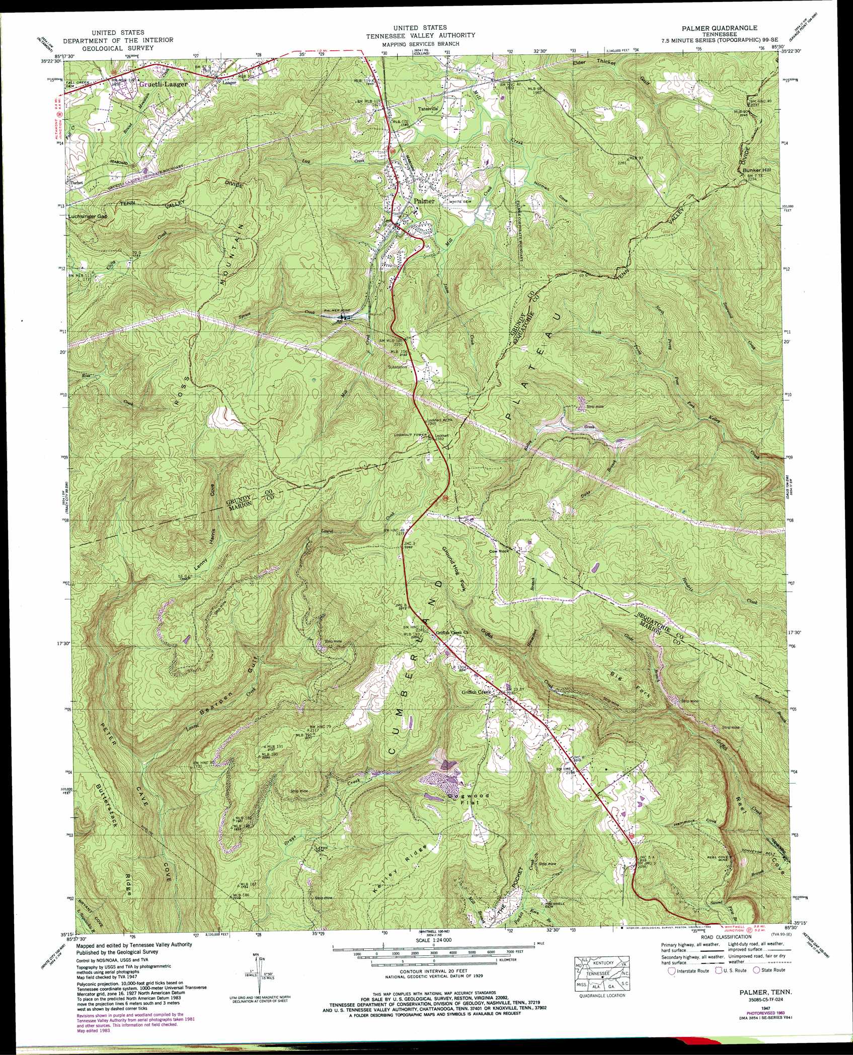
Palmer Topo Map Tennessee
To zoom in, hover over the map of Palmer
USGS Topo Quad 35085c5 - 1:24,000 scale
| Topo Map Name: | Palmer |
| USGS Topo Quad ID: | 35085c5 |
| Print Size: | ca. 21 1/4" wide x 27" high |
| Southeast Coordinates: | 35.25° N latitude / 85.5° W longitude |
| Map Center Coordinates: | 35.3125° N latitude / 85.5625° W longitude |
| U.S. State: | TN |
| Filename: | o35085c5.jpg |
| Download Map JPG Image: | Palmer topo map 1:24,000 scale |
| Map Type: | Topographic |
| Topo Series: | 7.5´ |
| Map Scale: | 1:24,000 |
| Source of Map Images: | United States Geological Survey (USGS) |
| Alternate Map Versions: |
Palmer TN 1936 Download PDF Buy paper map Palmer TN 1947, updated 1983 Download PDF Buy paper map Palmer TN 1947, updated 1983 Download PDF Buy paper map Palmer TN 1950 Download PDF Buy paper map Palmer TN 1950 Download PDF Buy paper map Palmer TN 2010 Download PDF Buy paper map Palmer TN 2013 Download PDF Buy paper map Palmer TN 2016 Download PDF Buy paper map |
1:24,000 Topo Quads surrounding Palmer
Viola |
Irving College |
Curtistown |
Smartt Mountain |
Brockdell |
Cane Hollow |
Altamont |
Collins |
Savage Point |
Mount Airy |
Burrow Cove |
Tracy City |
Palmer |
Daus |
Henson Gap |
Monteagle |
White City |
Whitwell |
Ketner Gap |
Fairmount |
Orme |
South Pittsburg |
Sequatchie |
Wauhatchie |
Chattanooga |
> Back to 35085a1 at 1:100,000 scale
> Back to 35084a1 at 1:250,000 scale
> Back to U.S. Topo Maps home
Palmer topo map: Gazetteer
Palmer: Flats
Dogwood Flat elevation 655m 2148′Palmer: Mines
Coal Valley Mine elevation 562m 1843′Palmer Mine elevation 559m 1833′
Reel Cove Mine elevation 546m 1791′
Palmer: Pillars
Cow Rock elevation 696m 2283′Palmer: Populated Places
Griffith Creek elevation 681m 2234′Gruetli-Laager elevation 584m 1916′
Laager elevation 578m 1896′
Palmer elevation 554m 1817′
Tatesville elevation 550m 1804′
Palmer: Ridges
Big Fork elevation 551m 1807′Butterstack Ridge elevation 534m 1751′
Ground Hog Fork elevation 666m 2185′
Kelley Ridge elevation 666m 2185′
Palmer: Streams
Dicks Branch elevation 493m 1617′First Branch elevation 497m 1630′
Glade Branch elevation 437m 1433′
Horseshoe Branch elevation 553m 1814′
Jakes Creek elevation 544m 1784′
Kern Branch elevation 499m 1637′
Laurel Creek elevation 337m 1105′
Lick Creek elevation 540m 1771′
North Prong Poor Fork elevation 509m 1669′
Poor Fork elevation 453m 1486′
Second Branch elevation 244m 800′
South Prong Poor Fork elevation 509m 1669′
Spruce Creek elevation 551m 1807′
Palmer: Summits
Bunker Hill elevation 703m 2306′Ross Mountain elevation 715m 2345′
Palmer: Valleys
Bearpen Gulf elevation 345m 1131′Hammock Cove elevation 272m 892′
Lenny Harris Cove elevation 508m 1666′
Norman Cove elevation 541m 1774′
Palmer digital topo map on disk
Buy this Palmer topo map showing relief, roads, GPS coordinates and other geographical features, as a high-resolution digital map file on DVD: