Alto Topo Map Tennessee
To zoom in, hover over the map of Alto
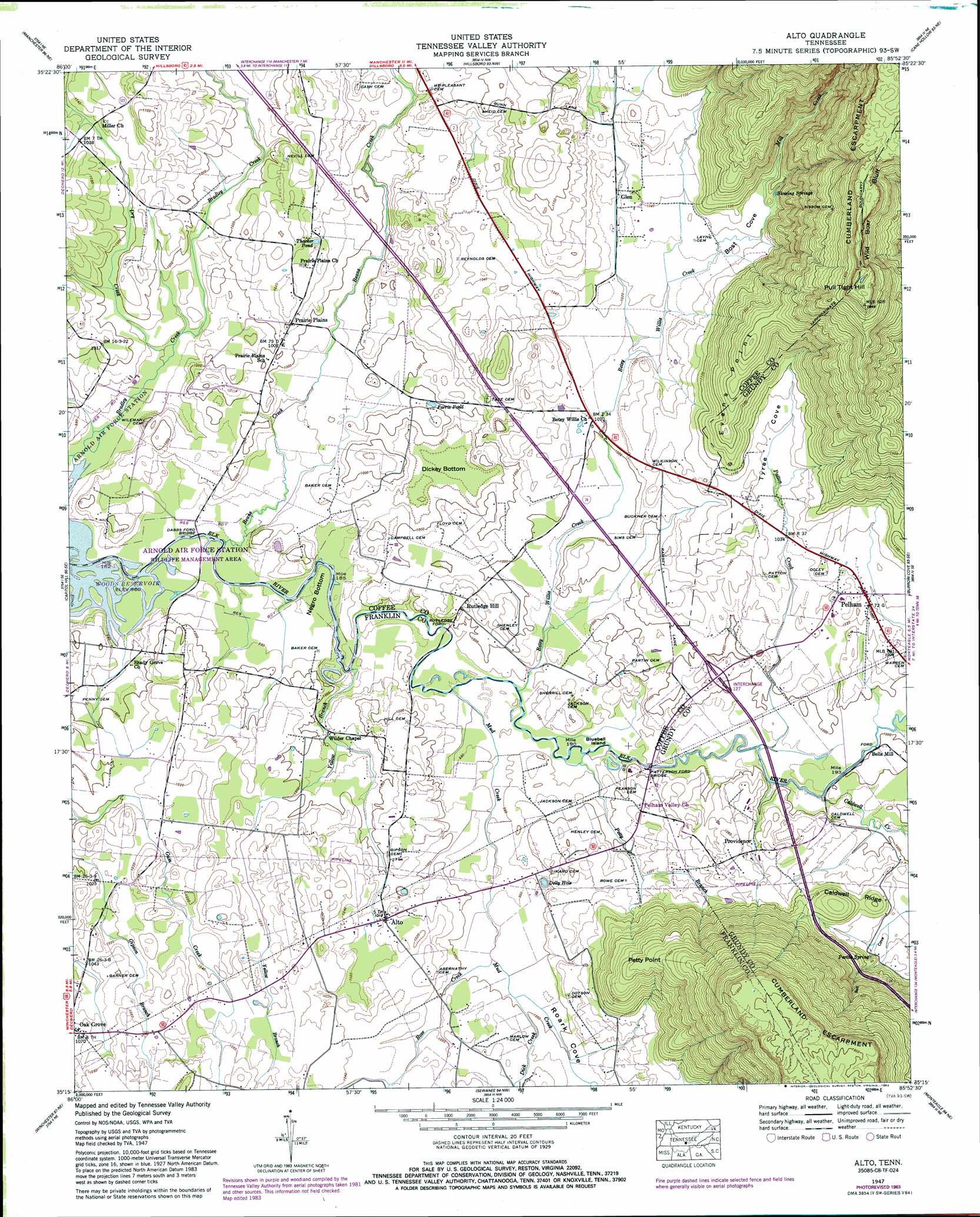
USGS Topo Quad 35085c8 - 1:24,000 scale
| Topo Map Name: | Alto |
| USGS Topo Quad ID: | 35085c8 |
| Print Size: | ca. 21 1/4" wide x 27" high |
| Southeast Coordinates: | 35.25° N latitude / 85.875° W longitude |
| Map Center Coordinates: | 35.3125° N latitude / 85.9375° W longitude |
| U.S. State: | TN |
| Filename: | o35085c8.jpg |
| Download Map JPG Image: | Alto topo map 1:24,000 scale |
| Map Type: | Topographic |
| Topo Series: | 7.5´ |
| Map Scale: | 1:24,000 |
| Source of Map Images: | United States Geological Survey (USGS) |
| Alternate Map Versions: |
Alto TN 1936 Download PDF Buy paper map Alto TN 1947, updated 1948 Download PDF Buy paper map Alto TN 1947, updated 1948 Download PDF Buy paper map Alto TN 1947, updated 1958 Download PDF Buy paper map Alto TN 1947, updated 1964 Download PDF Buy paper map Alto TN 1947, updated 1976 Download PDF Buy paper map Alto TN 1947, updated 1983 Download PDF Buy paper map Alto TN 1947, updated 1983 Download PDF Buy paper map Alto TN 1947, updated 1993 Download PDF Buy paper map Alto TN 2010 Download PDF Buy paper map Alto TN 2013 Download PDF Buy paper map Alto TN 2016 Download PDF Buy paper map |
1:24,000 Topo Quads surrounding Alto
Noah |
Fredonia |
Morrison |
Viola |
Irving College |
Normandy Lake |
Manchester |
Hillsboro |
Cane Hollow |
Altamont |
Tullahoma |
Capitol Hill |
Alto |
Burrow Cove |
Tracy City |
Belvidere |
Winchester |
Sewanee |
Monteagle |
White City |
Beans Creek |
Pitcher Ridge |
Sinking Cove |
Orme |
South Pittsburg |
> Back to 35085a1 at 1:100,000 scale
> Back to 35084a1 at 1:250,000 scale
> Back to U.S. Topo Maps home
Alto topo map: Gazetteer
Alto: Basins
Dickey Bottom elevation 296m 971′Alto: Bays
Delly Hole elevation 297m 974′Alto: Bends
Negro Bottom elevation 296m 971′Alto: Bridges
Caldwells Bridge (historical) elevation 298m 977′Dabbs Ford Bridge elevation 294m 964′
Patterson Ford Bridge elevation 298m 977′
Alto: Capes
Evans Point elevation 360m 1181′Petty Point elevation 410m 1345′
Alto: Cliffs
Wild Boar Bluff elevation 552m 1811′Alto: Crossings
Dabbs Ford elevation 294m 964′Interchange 127 elevation 310m 1017′
Ruthledge Ford elevation 296m 971′
Alto: Islands
Bluebell Island elevation 298m 977′Jail Island (historical) elevation 293m 961′
Alto: Lakes
Farris Pond elevation 304m 997′Thacker Pond elevation 311m 1020′
Alto: Populated Places
Alto elevation 311m 1020′Bells Mill elevation 305m 1000′
Betsy Willis elevation 308m 1010′
Glen elevation 314m 1030′
Oak Grove elevation 325m 1066′
Pelham elevation 312m 1023′
Prairie Plains elevation 310m 1017′
Providence elevation 319m 1046′
Ruthledge Hill elevation 313m 1026′
Shady Grove elevation 300m 984′
Wilder Chapel elevation 300m 984′
Alto: Post Offices
Pelham Post Office elevation 312m 1023′Alto: Ridges
Caldwell Ridge elevation 335m 1099′Alto: Springs
Blowing Springs elevation 323m 1059′Partin Spring elevation 311m 1020′
Alto: Streams
Beans Creek elevation 294m 964′Betsy Willis Creek elevation 297m 974′
Caldwell Creek elevation 299m 980′
Dick Creek elevation 304m 997′
Dry Creek elevation 295m 967′
Gipson Branch elevation 302m 990′
Mill Creek elevation 318m 1043′
Mud Creek elevation 296m 971′
Patton Creek elevation 298m 977′
Petty Branch elevation 297m 974′
Rose Creek elevation 303m 994′
Yellow Branch elevation 296m 971′
Alto: Summits
Pull Tight Hill elevation 598m 1961′Alto: Valleys
Bell Cove elevation 309m 1013′Bost Cove elevation 315m 1033′
Pelham Valley elevation 310m 1017′
Roark Cove elevation 299m 980′
Tyree Cove elevation 317m 1040′
Alto digital topo map on disk
Buy this Alto topo map showing relief, roads, GPS coordinates and other geographical features, as a high-resolution digital map file on DVD: