Irving College Topo Map Tennessee
To zoom in, hover over the map of Irving College
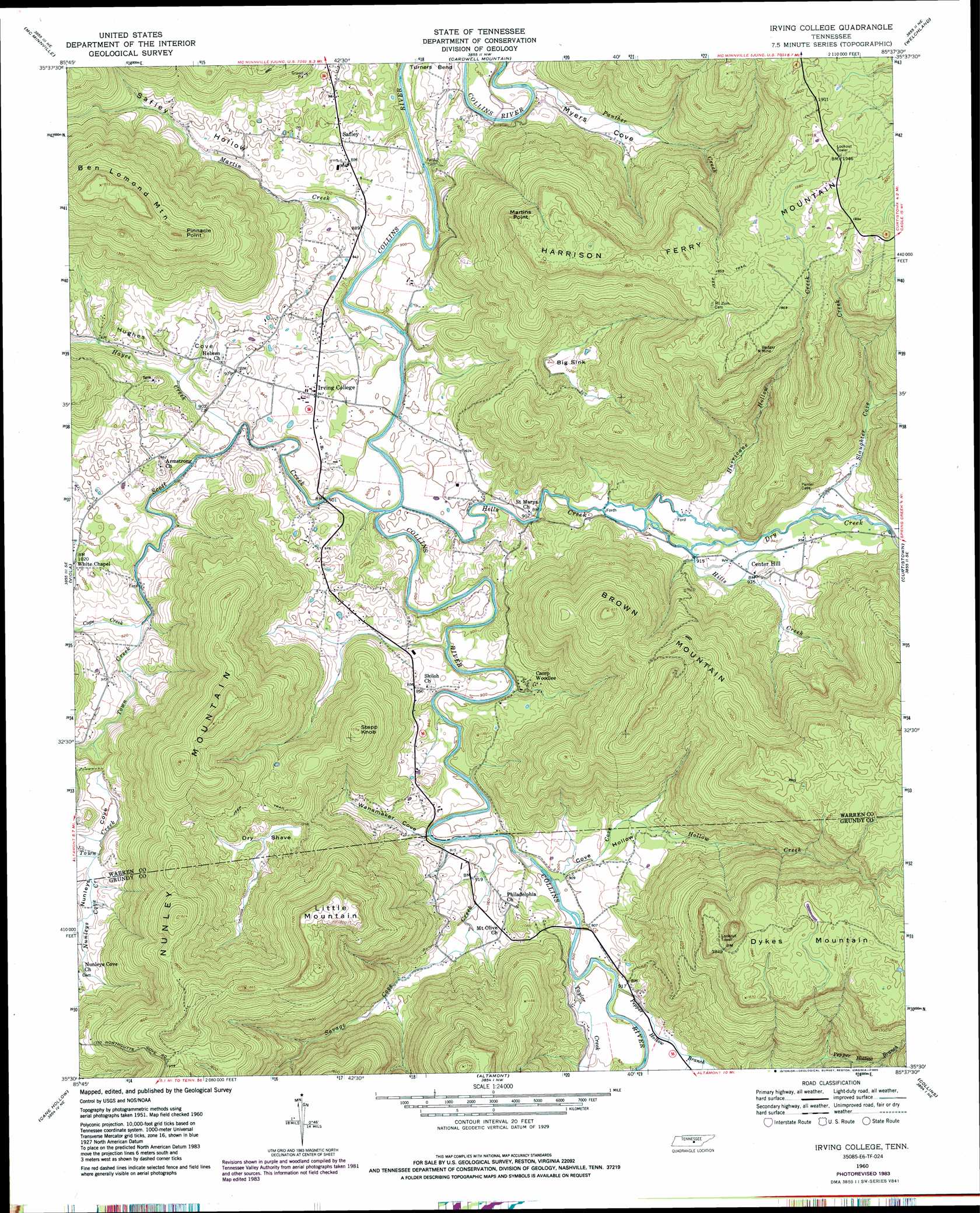
USGS Topo Quad 35085e6 - 1:24,000 scale
| Topo Map Name: | Irving College |
| USGS Topo Quad ID: | 35085e6 |
| Print Size: | ca. 21 1/4" wide x 27" high |
| Southeast Coordinates: | 35.5° N latitude / 85.625° W longitude |
| Map Center Coordinates: | 35.5625° N latitude / 85.6875° W longitude |
| U.S. State: | TN |
| Filename: | o35085e6.jpg |
| Download Map JPG Image: | Irving College topo map 1:24,000 scale |
| Map Type: | Topographic |
| Topo Series: | 7.5´ |
| Map Scale: | 1:24,000 |
| Source of Map Images: | United States Geological Survey (USGS) |
| Alternate Map Versions: |
Irving College TN 1960, updated 1962 Download PDF Buy paper map Irving College TN 1960, updated 1969 Download PDF Buy paper map Irving College TN 1960, updated 1986 Download PDF Buy paper map Irving College TN 1960, updated 1986 Download PDF Buy paper map Irving College TN 2010 Download PDF Buy paper map Irving College TN 2013 Download PDF Buy paper map Irving College TN 2016 Download PDF Buy paper map |
1:24,000 Topo Quads surrounding Irving College
Short Mountain |
Dibrell |
Campaign |
Doyle |
Bald Knob |
Centertown |
Mcminnville |
Cardwell Mountain |
Welchland |
Spencer |
Morrison |
Viola |
Irving College |
Curtistown |
Smartt Mountain |
Hillsboro |
Cane Hollow |
Altamont |
Collins |
Savage Point |
Alto |
Burrow Cove |
Tracy City |
Palmer |
Daus |
> Back to 35085e1 at 1:100,000 scale
> Back to 35084a1 at 1:250,000 scale
> Back to U.S. Topo Maps home
Irving College topo map: Gazetteer
Irving College: Basins
Big Sink elevation 343m 1125′Dry Shave elevation 345m 1131′
Irving College: Capes
Martins Point elevation 556m 1824′Perry Point elevation 550m 1804′
Pinnacle Point elevation 549m 1801′
Irving College: Crossings
Martins Ford elevation 267m 875′Irving College: Mines
Badger Mine elevation 553m 1814′Grissom Quarry elevation 338m 1108′
Irving College: Populated Places
Harrican (historical) elevation 297m 974′Irving College elevation 288m 944′
Isleford elevation 267m 875′
Mount Olive elevation 285m 935′
Safley elevation 293m 961′
Steppsville elevation 294m 964′
Irving College: Ridges
Knowles Ridge elevation 440m 1443′Irving College: Streams
Cove Hollow Creek elevation 268m 879′Dry Creek elevation 276m 905′
Hayes Creek elevation 268m 879′
Hills Creek elevation 267m 875′
Hurricane Hollow Creek elevation 280m 918′
Martin Creek elevation 267m 875′
Nunleys Cove Creek elevation 305m 1000′
Panther Creek elevation 266m 872′
Pepper Hollow Branch elevation 273m 895′
Savage Cove Creek elevation 267m 875′
Scott Creek elevation 267m 875′
Slaughter Cove Creek elevation 287m 941′
Taylor Creek elevation 271m 889′
Town Creek elevation 276m 905′
Irving College: Summits
Brown Mountain elevation 556m 1824′Dykes Mountain elevation 571m 1873′
Harrison Ferry Mountain elevation 592m 1942′
Little Mountain elevation 582m 1909′
Nunley Mountain elevation 560m 1837′
Stepp Knob elevation 473m 1551′
Irving College: Valleys
Cove Hollow elevation 271m 889′Gross Cove elevation 293m 961′
Hughes Cove elevation 300m 984′
Hurricane Hollow elevation 281m 921′
Long Cove elevation 275m 902′
Myers Cove elevation 279m 915′
Nunleys Cove elevation 300m 984′
Safley Hollow elevation 297m 974′
Slaughter Cove elevation 301m 987′
Wanamaker Cove elevation 268m 879′
Irving College digital topo map on disk
Buy this Irving College topo map showing relief, roads, GPS coordinates and other geographical features, as a high-resolution digital map file on DVD: