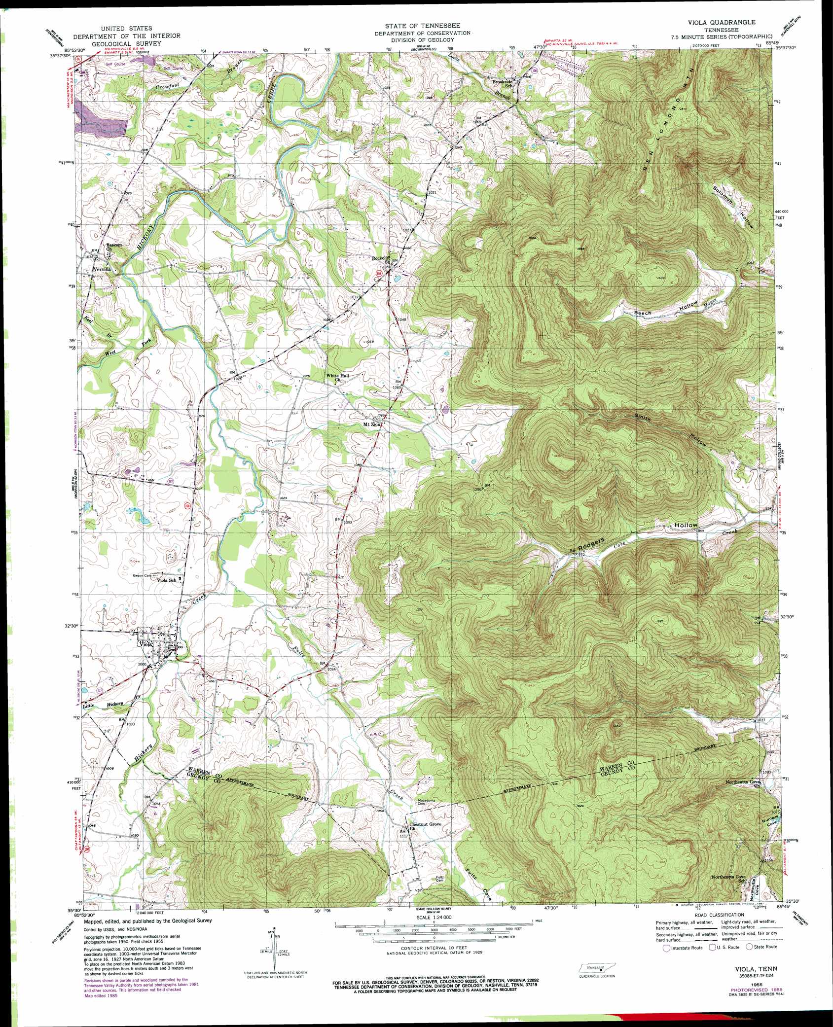
Viola Topo Map Tennessee
To zoom in, hover over the map of Viola
USGS Topo Quad 35085e7 - 1:24,000 scale
| Topo Map Name: | Viola |
| USGS Topo Quad ID: | 35085e7 |
| Print Size: | ca. 21 1/4" wide x 27" high |
| Southeast Coordinates: | 35.5° N latitude / 85.75° W longitude |
| Map Center Coordinates: | 35.5625° N latitude / 85.8125° W longitude |
| U.S. State: | TN |
| Filename: | o35085e7.jpg |
| Download Map JPG Image: | Viola topo map 1:24,000 scale |
| Map Type: | Topographic |
| Topo Series: | 7.5´ |
| Map Scale: | 1:24,000 |
| Source of Map Images: | United States Geological Survey (USGS) |
| Alternate Map Versions: |
Viola TN 1955, updated 1956 Download PDF Buy paper map Viola TN 1955, updated 1987 Download PDF Buy paper map Viola TN 2010 Download PDF Buy paper map Viola TN 2013 Download PDF Buy paper map Viola TN 2016 Download PDF Buy paper map |
1:24,000 Topo Quads surrounding Viola
Woodbury |
Short Mountain |
Dibrell |
Campaign |
Doyle |
Hollow Springs |
Centertown |
Mcminnville |
Cardwell Mountain |
Welchland |
Fredonia |
Morrison |
Viola |
Irving College |
Curtistown |
Manchester |
Hillsboro |
Cane Hollow |
Altamont |
Collins |
Capitol Hill |
Alto |
Burrow Cove |
Tracy City |
Palmer |
> Back to 35085e1 at 1:100,000 scale
> Back to 35084a1 at 1:250,000 scale
> Back to U.S. Topo Maps home
Viola topo map: Gazetteer
Viola: Bridges
Mount Olive Bridge elevation 526m 1725′Viola: Dams
Harvest Farms Lake Dam elevation 300m 984′Viola: Gaps
The Narrows elevation 329m 1079′Viola: Populated Places
Chestnut Grove elevation 339m 1112′Mount Zion elevation 323m 1059′
Northcutts Cove elevation 342m 1122′
Vervilla elevation 317m 1040′
Viola elevation 305m 1000′
Viola: Reservoirs
Harvest Farms Lake elevation 300m 984′Viola: Springs
Big Spring elevation 324m 1062′Viola: Streams
Fultz Creek elevation 299m 980′Keel Branch elevation 294m 964′
Little Hickory Creek elevation 303m 994′
Smith Hollow elevation 283m 928′
West Fork Hickory Creek elevation 292m 958′
Viola: Summits
Butterson Knob elevation 590m 1935′Viola: Valleys
Beech Hollow elevation 322m 1056′Fultz Cove elevation 325m 1066′
Northcutts Cove elevation 334m 1095′
Rodgers Hollow elevation 282m 925′
Solomon Hollow elevation 309m 1013′
Viola digital topo map on disk
Buy this Viola topo map showing relief, roads, GPS coordinates and other geographical features, as a high-resolution digital map file on DVD: