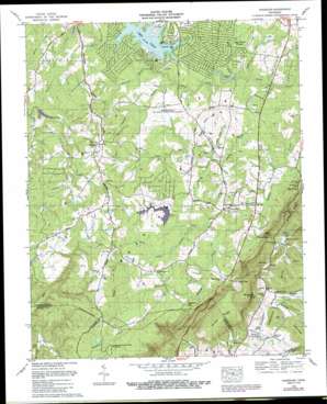
Vandever Topo Map Tennessee
To zoom in, hover over the map of Vandever
USGS Topo Quad 35085g1 - 1:24,000 scale
| Topo Map Name: | Vandever |
| USGS Topo Quad ID: | 35085g1 |
| Print Size: | ca. 21 1/4" wide x 27" high |
| Southeast Coordinates: | 35.75° N latitude / 85° W longitude |
| Map Center Coordinates: | 35.8125° N latitude / 85.0625° W longitude |
| U.S. State: | TN |
| Filename: | o35085g1.jpg |
| Download Map JPG Image: | Vandever topo map 1:24,000 scale |
| Map Type: | Topographic |
| Topo Series: | 7.5´ |
| Map Scale: | 1:24,000 |
| Source of Map Images: | United States Geological Survey (USGS) |
| Alternate Map Versions: |
Vandever TN 1935 Download PDF Buy paper map Vandever TN 1956, updated 1958 Download PDF Buy paper map Vandever TN 1956, updated 1971 Download PDF Buy paper map Vandever TN 1956, updated 1977 Download PDF Buy paper map Vandever TN 1983, updated 1989 Download PDF Buy paper map Vandever TN 2010 Download PDF Buy paper map Vandever TN 2013 Download PDF Buy paper map Vandever TN 2016 Download PDF Buy paper map |
1:24,000 Topo Quads surrounding Vandever
> Back to 35085e1 at 1:100,000 scale
> Back to 35084a1 at 1:250,000 scale
> Back to U.S. Topo Maps home
Vandever topo map: Gazetteer
Vandever: Basins
Hellhole elevation 552m 1811′Vandever: Dams
Melvin Smith Lake Dam elevation 597m 1958′Tansi Lake Dam elevation 568m 1863′
Vandever: Gaps
Brown Gap elevation 533m 1748′Morris Gap elevation 552m 1811′
Parham Gap elevation 551m 1807′
Stephens Gap elevation 568m 1863′
Vandever: Populated Places
Big Lick elevation 536m 1758′Burke elevation 302m 990′
Hilltop Acres elevation 611m 2004′
Kiowa Subdivision elevation 582m 1909′
Lake Tansi elevation 585m 1919′
Music (historical) elevation 561m 1840′
New Era elevation 612m 2007′
Nicholson Heights elevation 599m 1965′
Oak Grove elevation 578m 1896′
Ojibwa Subdivision elevation 573m 1879′
Oneida Subdivision elevation 590m 1935′
Parham elevation 321m 1053′
Pleasant View Estates elevation 572m 1876′
Seminole Subdivision elevation 573m 1879′
Vandever elevation 599m 1965′
Winnebago Subdivision elevation 575m 1886′
Wyatt (historical) elevation 604m 1981′
Vandever: Reservoirs
Lake Tansi elevation 568m 1863′Melvin Smith Lake elevation 597m 1958′
Vandever: Ridges
Brown Ridge elevation 525m 1722′Pee Dee Ridge elevation 422m 1384′
Vandever: Springs
Carding Machine Spring elevation 296m 971′Head of Sequatchie elevation 330m 1082′
Manning Spring elevation 305m 1000′
Stacy Spring elevation 296m 971′
Vandever: Streams
Apple Orchard Branch elevation 534m 1751′Big Branch elevation 513m 1683′
Burnt Cabin Branch elevation 540m 1771′
Cottrell Branch elevation 546m 1791′
Flatrock Branch elevation 548m 1797′
Hog Heaven Branch elevation 539m 1768′
Lick Creek elevation 534m 1751′
Long Branch elevation 535m 1755′
Muddy Branch elevation 536m 1758′
Perry Creek elevation 557m 1827′
Roaring Branch elevation 297m 974′
Salton Creek elevation 513m 1683′
Selby Creek elevation 325m 1066′
Sulphur Spring Branch elevation 536m 1758′
Wilson Branch elevation 296m 971′
Wilson Pen Branch elevation 537m 1761′
Vandever: Summits
Blalock Knob elevation 593m 1945′Vandever: Valleys
Devilstep Hollow elevation 327m 1072′Gravelly Spur elevation 340m 1115′
Vandever digital topo map on disk
Buy this Vandever topo map showing relief, roads, GPS coordinates and other geographical features, as a high-resolution digital map file on DVD:


