Doyle Topo Map Tennessee
To zoom in, hover over the map of Doyle
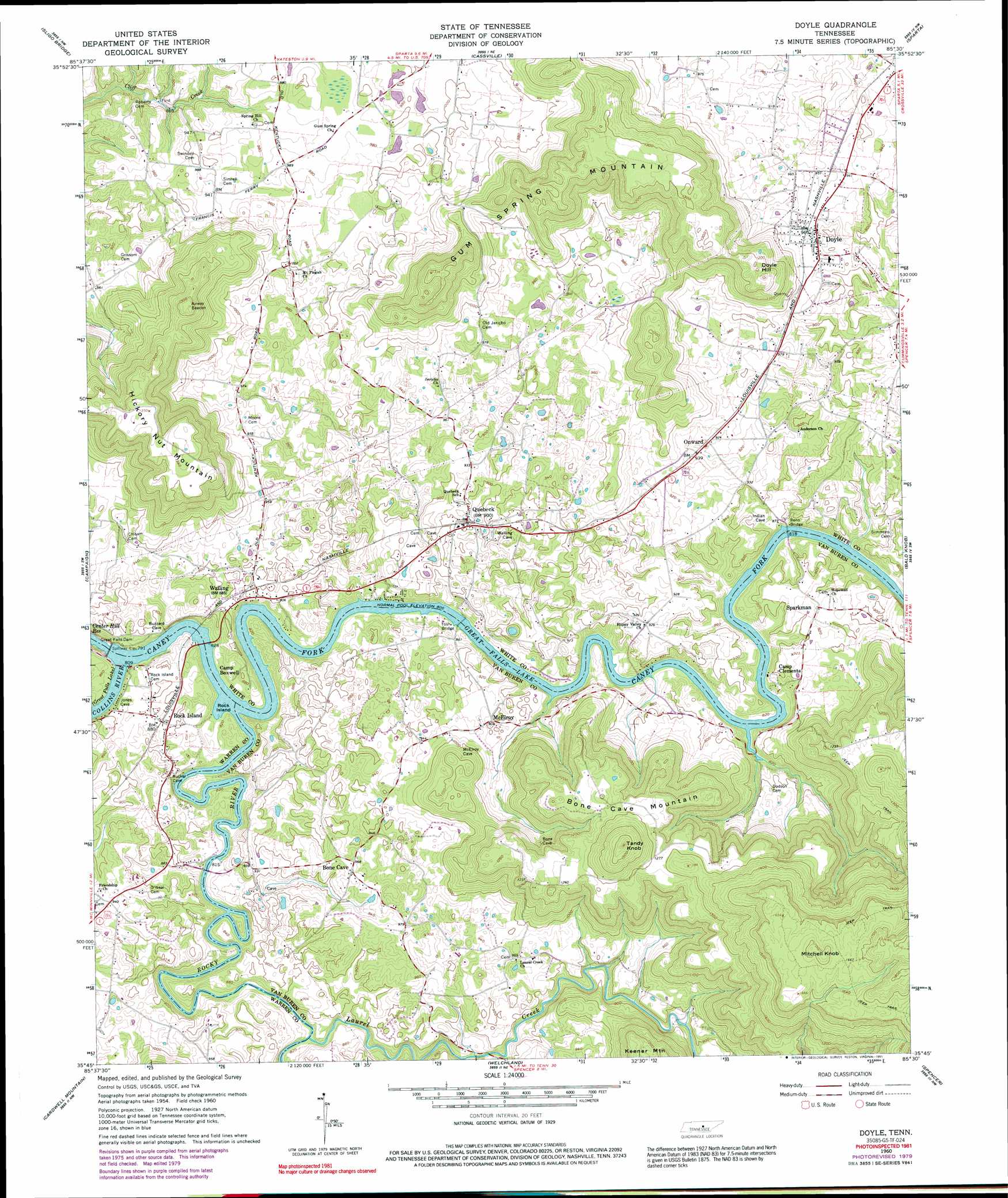
USGS Topo Quad 35085g5 - 1:24,000 scale
| Topo Map Name: | Doyle |
| USGS Topo Quad ID: | 35085g5 |
| Print Size: | ca. 21 1/4" wide x 27" high |
| Southeast Coordinates: | 35.75° N latitude / 85.5° W longitude |
| Map Center Coordinates: | 35.8125° N latitude / 85.5625° W longitude |
| U.S. State: | TN |
| Filename: | o35085g5.jpg |
| Download Map JPG Image: | Doyle topo map 1:24,000 scale |
| Map Type: | Topographic |
| Topo Series: | 7.5´ |
| Map Scale: | 1:24,000 |
| Source of Map Images: | United States Geological Survey (USGS) |
| Alternate Map Versions: |
Doyle TN 1960, updated 1961 Download PDF Buy paper map Doyle TN 1960, updated 1971 Download PDF Buy paper map Doyle TN 1960, updated 1979 Download PDF Buy paper map Doyle TN 1960, updated 1991 Download PDF Buy paper map Doyle TN 2010 Download PDF Buy paper map Doyle TN 2013 Download PDF Buy paper map Doyle TN 2016 Download PDF Buy paper map |
1:24,000 Topo Quads surrounding Doyle
Center Hill Dam |
Silver Point |
Burgess Falls |
Dry Valley |
Monterey Lake |
Smithville |
Sligo Bridge |
Cassville |
Sparta |
De Rossett |
Dibrell |
Campaign |
Doyle |
Bald Knob |
Lonewood |
Mcminnville |
Cardwell Mountain |
Welchland |
Spencer |
Sampson |
Viola |
Irving College |
Curtistown |
Smartt Mountain |
Brockdell |
> Back to 35085e1 at 1:100,000 scale
> Back to 35084a1 at 1:250,000 scale
> Back to U.S. Topo Maps home
Doyle topo map: Gazetteer
Doyle: Bridges
Reno Bridge elevation 245m 803′Tosh Bridge elevation 245m 803′
Doyle: Crossings
Cummings Ford (historical) elevation 245m 803′Denny Ferry (historical) elevation 245m 803′
Denny Ford (historical) elevation 245m 803′
Dillon Ferry (historical) elevation 245m 803′
Dillon Ford (historical) elevation 245m 803′
Hash Ford (historical) elevation 245m 803′
McElroy Ferry (historical) elevation 245m 803′
McElroy Ford (historical) elevation 245m 803′
Doyle: Dams
Great Falls Dam elevation 224m 734′Doyle: Islands
Rock Island elevation 245m 803′Doyle: Parks
Bone Cave State Park elevation 378m 1240′Doyle: Populated Places
Bone Cave elevation 294m 964′Doyle elevation 286m 938′
Heads (historical) elevation 301m 987′
Laurel Creek elevation 294m 964′
McElroy elevation 274m 898′
Mount Pisgah elevation 306m 1003′
Pollard (historical) elevation 275m 902′
Quebeck elevation 274m 898′
Rock Island elevation 272m 892′
Sparkman elevation 280m 918′
Walling elevation 270m 885′
Doyle: Post Offices
Bone Cave Post Office elevation 292m 958′Quebec Post Office elevation 271m 889′
Rock Island Post Office elevation 273m 895′
Walling Post Office elevation 274m 898′
Doyle: Reservoirs
Great Falls Lake elevation 224m 734′Doyle: Streams
Collins River elevation 245m 803′Dry Branch elevation 247m 810′
Laurel Creek elevation 247m 810′
Little Double Branch elevation 245m 803′
Rocky River elevation 245m 803′
Doyle: Summits
Bone Cave Mountain elevation 397m 1302′Doyle Hill elevation 375m 1230′
Dukes Mountain elevation 428m 1404′
Mitchell Knob elevation 531m 1742′
Tandy Knob elevation 481m 1578′
Doyle digital topo map on disk
Buy this Doyle topo map showing relief, roads, GPS coordinates and other geographical features, as a high-resolution digital map file on DVD: