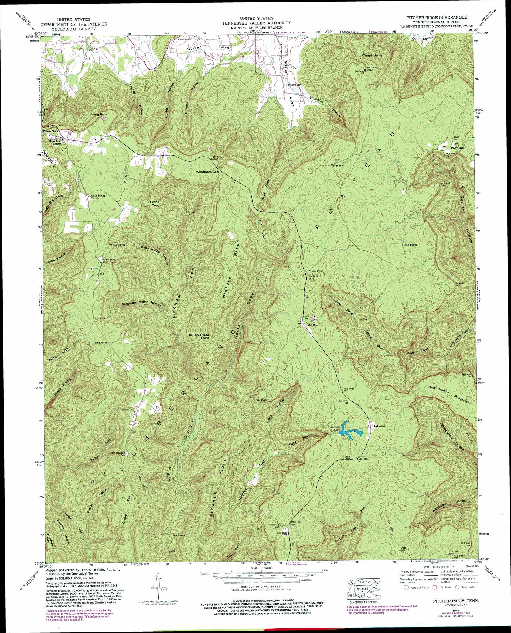
Pitcher Ridge Topo Map Tennessee
To zoom in, hover over the map of Pitcher Ridge
USGS Topo Quad 35086a1 - 1:24,000 scale
| Topo Map Name: | Pitcher Ridge |
| USGS Topo Quad ID: | 35086a1 |
| Print Size: | ca. 21 1/4" wide x 27" high |
| Southeast Coordinates: | 35° N latitude / 86° W longitude |
| Map Center Coordinates: | 35.0625° N latitude / 86.0625° W longitude |
| U.S. State: | TN |
| Filename: | o35086a1.jpg |
| Download Map JPG Image: | Pitcher Ridge topo map 1:24,000 scale |
| Map Type: | Topographic |
| Topo Series: | 7.5´ |
| Map Scale: | 1:24,000 |
| Source of Map Images: | United States Geological Survey (USGS) |
| Alternate Map Versions: |
Pitcher Ridge TN 1936 Download PDF Buy paper map Pitcher Ridge TN 1948, updated 1974 Download PDF Buy paper map Pitcher Ridge TN 1948, updated 1977 Download PDF Buy paper map Pitcher Ridge TN 1948, updated 1982 Download PDF Buy paper map Pitcher Ridge TN 1951 Download PDF Buy paper map Pitcher Ridge TN 2010 Download PDF Buy paper map Pitcher Ridge TN 2013 Download PDF Buy paper map Pitcher Ridge TN 2016 Download PDF Buy paper map |
1:24,000 Topo Quads surrounding Pitcher Ridge
Lynchburg East |
Tullahoma |
Capitol Hill |
Alto |
Burrow Cove |
Lois |
Belvidere |
Winchester |
Sewanee |
Monteagle |
Huntland |
Beans Creek |
Pitcher Ridge |
Sinking Cove |
Orme |
King Cove |
Estill Fork |
Hytop |
Eureka |
Doran Cove |
Hollytree |
Princeton |
Mud Creek |
Wannville |
Stevenson |
> Back to 35086a1 at 1:100,000 scale
> Back to 35086a1 at 1:250,000 scale
> Back to U.S. Topo Maps home
Pitcher Ridge topo map: Gazetteer
Pitcher Ridge: Basins
Cave Cove elevation 399m 1309′Crabtree Cove elevation 381m 1250′
Denson Cove elevation 516m 1692′
Farmer Cove elevation 361m 1184′
Gray Cove elevation 295m 967′
The Sinks elevation 307m 1007′
Wolf Cove elevation 294m 964′
Pitcher Ridge: Benches
Murrell Bench elevation 435m 1427′Pitcher Ridge: Cliffs
Long Point elevation 576m 1889′Pitcher Ridge: Dams
Lakeview Lake Number One Dam elevation 544m 1784′Pitcher Ridge: Gaps
Windtrace Gap elevation 556m 1824′Pitcher Ridge: Populated Places
Keith Springs elevation 567m 1860′Lakeview elevation 562m 1843′
Sal City elevation 568m 1863′
Three Forks elevation 562m 1843′
Pitcher Ridge: Reservoirs
Lakeview Lake Number One elevation 544m 1784′Pitcher Ridge: Ridges
Hickory Ridge elevation 554m 1817′Pitcher Ridge elevation 502m 1646′
Pitcher Ridge: Springs
Cold Spring elevation 566m 1856′Keith Spring elevation 545m 1788′
Sal City Spring elevation 553m 1814′
Turnpike Spring elevation 527m 1729′
Pitcher Ridge: Summits
Bear Hollow Mountain elevation 550m 1804′Cooper Top elevation 544m 1784′
Crane Top elevation 562m 1843′
Pitcher Ridge: Valleys
Bingham Cove elevation 302m 990′Cat Cove elevation 504m 1653′
Davis Cove elevation 304m 997′
Holder Cove elevation 293m 961′
Holder Hollow elevation 311m 1020′
Horse Cove elevation 302m 990′
Keith Spring Hollow elevation 359m 1177′
Long Hollow elevation 390m 1279′
Looney Hollow elevation 317m 1040′
Mary Hollow elevation 395m 1295′
Milksick Hollow elevation 305m 1000′
Poplar Hollow elevation 352m 1154′
Snowbird Hollow elevation 305m 1000′
Sorghum Patch Hollow elevation 353m 1158′
Pitcher Ridge digital topo map on disk
Buy this Pitcher Ridge topo map showing relief, roads, GPS coordinates and other geographical features, as a high-resolution digital map file on DVD: