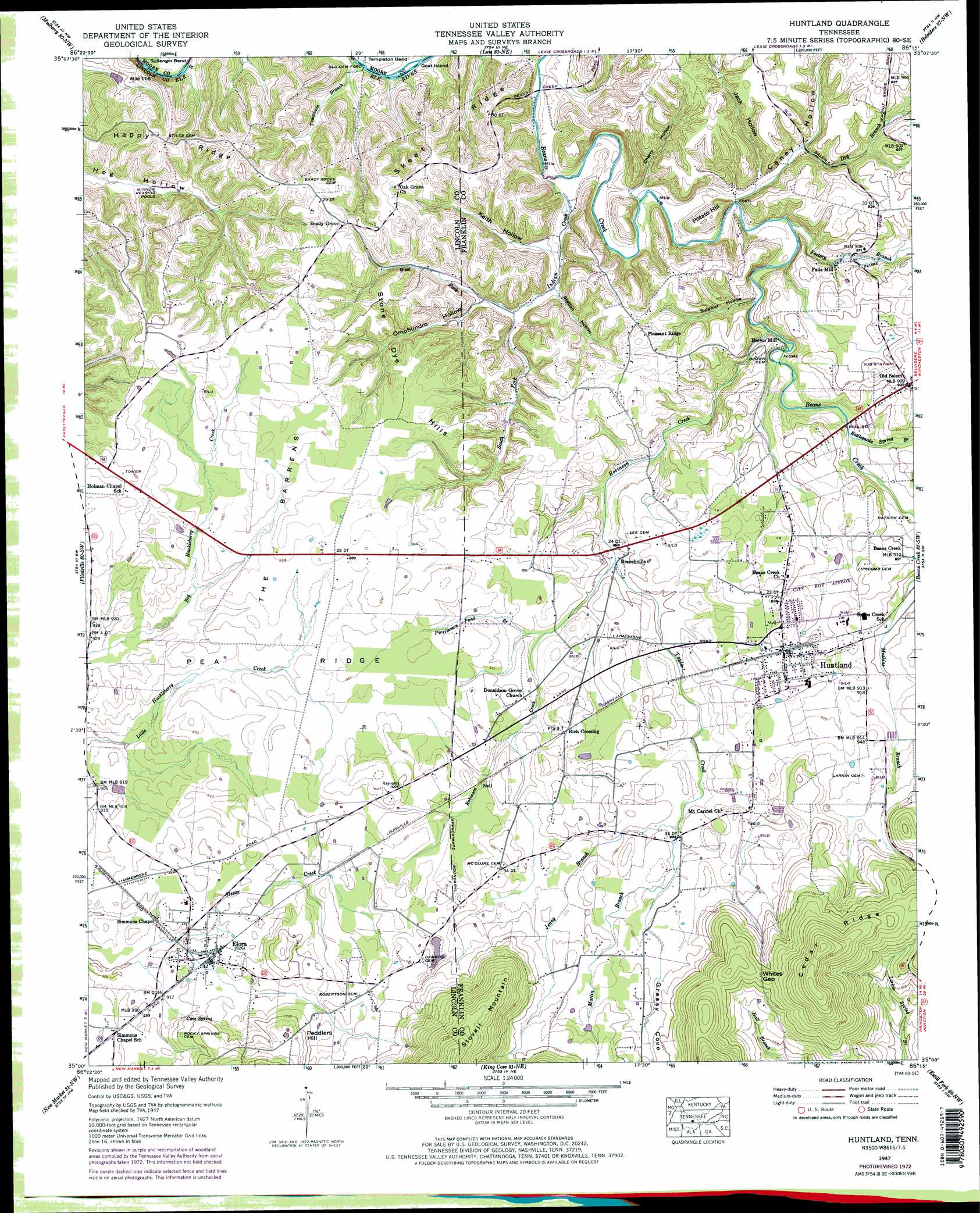
Huntland Topo Map Tennessee
To zoom in, hover over the map of Huntland
USGS Topo Quad 35086a3 - 1:24,000 scale
| Topo Map Name: | Huntland |
| USGS Topo Quad ID: | 35086a3 |
| Print Size: | ca. 21 1/4" wide x 27" high |
| Southeast Coordinates: | 35° N latitude / 86.25° W longitude |
| Map Center Coordinates: | 35.0625° N latitude / 86.3125° W longitude |
| U.S. State: | TN |
| Filename: | o35086a3.jpg |
| Download Map JPG Image: | Huntland topo map 1:24,000 scale |
| Map Type: | Topographic |
| Topo Series: | 7.5´ |
| Map Scale: | 1:24,000 |
| Source of Map Images: | United States Geological Survey (USGS) |
| Alternate Map Versions: |
Huntland TN 1936 Download PDF Buy paper map Huntland TN 1947, updated 1948 Download PDF Buy paper map Huntland TN 1947, updated 1965 Download PDF Buy paper map Huntland TN 1947, updated 1973 Download PDF Buy paper map Huntland TN 1947, updated 1973 Download PDF Buy paper map Huntland TN 2010 Download PDF Buy paper map Huntland TN 2013 Download PDF Buy paper map Huntland TN 2016 Download PDF Buy paper map |
1:24,000 Topo Quads surrounding Huntland
Belleville |
Lynchburg West |
Lynchburg East |
Tullahoma |
Capitol Hill |
Fayetteville |
Mulberry |
Lois |
Belvidere |
Winchester |
Lincoln |
Flintville |
Huntland |
Beans Creek |
Pitcher Ridge |
Fisk |
New Market |
King Cove |
Estill Fork |
Hytop |
Meridianville |
Maysville |
Hollytree |
Princeton |
Mud Creek |
> Back to 35086a1 at 1:100,000 scale
> Back to 35086a1 at 1:250,000 scale
> Back to U.S. Topo Maps home
Huntland topo map: Gazetteer
Huntland: Bends
Templeton Bend elevation 220m 721′Huntland: Crossings
Old Dam Ford elevation 217m 711′Huntland: Flats
The Barrens elevation 293m 961′Huntland: Gaps
Whites Gap elevation 347m 1138′Huntland: Islands
Goat Island elevation 219m 718′Huntland: Populated Places
Branchville elevation 268m 879′Brown Mill elevation 243m 797′
Elora elevation 283m 928′
Falls Mill elevation 251m 823′
Huntland elevation 287m 941′
Mount Carmel elevation 292m 958′
Neil elevation 286m 938′
Old Salem elevation 281m 921′
Shady Grove elevation 292m 958′
Huntland: Post Offices
Elora Post Office elevation 282m 925′Huntland Post Office elevation 288m 944′
Huntland: Ridges
Happy Ridge elevation 293m 961′Skeet Ridge elevation 289m 948′
Stone Dye Hills elevation 294m 964′
Huntland: Springs
Cave Spring elevation 281m 921′Huntland: Streams
Caney Hollow Creek elevation 234m 767′Dog Branch elevation 236m 774′
Factory Branch elevation 234m 767′
Indian Creek elevation 222m 728′
Jenny Branch elevation 283m 928′
Martin Branch elevation 286m 938′
Martin Branch elevation 286m 938′
Persimmon Pond Branch elevation 279m 915′
Rattlesnake Spring Branch elevation 253m 830′
Robinson Creek elevation 240m 787′
South Fork Indian Creek elevation 234m 767′
Taylor Creek elevation 266m 872′
West Fork Indian Creek elevation 234m 767′
Huntland: Summits
Peddlers Hill elevation 319m 1046′Potato Hill elevation 275m 902′
Stovall Mountain elevation 393m 1289′
Huntland: Valleys
Arnold Hollow elevation 236m 774′Caney Hollow elevation 230m 754′
Cherry Hollow elevation 230m 754′
Greasy Cove elevation 290m 951′
Jack Hollow elevation 235m 770′
Keith Hollow elevation 234m 767′
Omohundro Hollow elevation 238m 780′
Station Hollow elevation 237m 777′
Sulphur Hollow elevation 240m 787′
Huntland digital topo map on disk
Buy this Huntland topo map showing relief, roads, GPS coordinates and other geographical features, as a high-resolution digital map file on DVD: