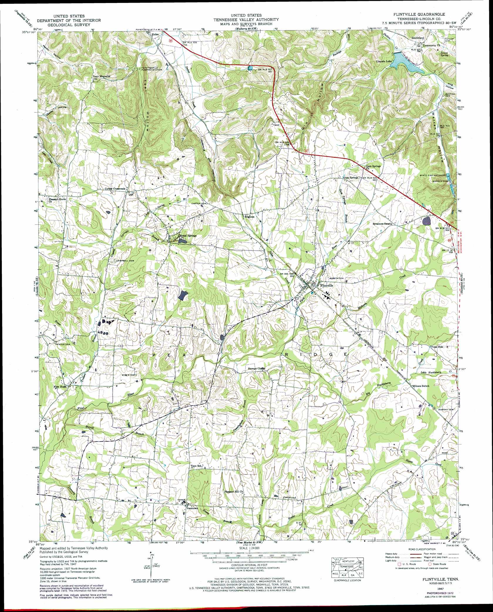
Flintville Topo Map Tennessee
To zoom in, hover over the map of Flintville
USGS Topo Quad 35086a4 - 1:24,000 scale
| Topo Map Name: | Flintville |
| USGS Topo Quad ID: | 35086a4 |
| Print Size: | ca. 21 1/4" wide x 27" high |
| Southeast Coordinates: | 35° N latitude / 86.375° W longitude |
| Map Center Coordinates: | 35.0625° N latitude / 86.4375° W longitude |
| U.S. State: | TN |
| Filename: | o35086a4.jpg |
| Download Map JPG Image: | Flintville topo map 1:24,000 scale |
| Map Type: | Topographic |
| Topo Series: | 7.5´ |
| Map Scale: | 1:24,000 |
| Source of Map Images: | United States Geological Survey (USGS) |
| Alternate Map Versions: |
Flintville TN 1936 Download PDF Buy paper map Flintville TN 1947, updated 1948 Download PDF Buy paper map Flintville TN 1947, updated 1967 Download PDF Buy paper map Flintville TN 1947, updated 1973 Download PDF Buy paper map Flintville TN 2010 Download PDF Buy paper map Flintville TN 2013 Download PDF Buy paper map Flintville TN 2016 Download PDF Buy paper map |
1:24,000 Topo Quads surrounding Flintville
Petersburg |
Belleville |
Lynchburg West |
Lynchburg East |
Tullahoma |
Boonshill |
Fayetteville |
Mulberry |
Lois |
Belvidere |
Taft |
Lincoln |
Flintville |
Huntland |
Beans Creek |
Toney |
Fisk |
New Market |
King Cove |
Estill Fork |
Jeff |
Meridianville |
Maysville |
Hollytree |
Princeton |
> Back to 35086a1 at 1:100,000 scale
> Back to 35086a1 at 1:250,000 scale
> Back to U.S. Topo Maps home
Flintville topo map: Gazetteer
Flintville: Dams
Lincoln Lake Dam elevation 222m 728′Steelman Lake Dam elevation 286m 938′
Flintville: Populated Places
Brighton elevation 290m 951′Corder Crossroads elevation 273m 895′
Crystal Springs elevation 286m 938′
Flintville elevation 275m 902′
Gum Springs elevation 287m 941′
New Hope elevation 250m 820′
Smithland elevation 243m 797′
Sycamore Swamp elevation 291m 954′
Vanntown elevation 282m 925′
Flintville: Post Offices
Flintville Post Office elevation 276m 905′Flintville: Reservoirs
Lincoln Lake elevation 222m 728′Steelman Lake elevation 286m 938′
Flintville: Springs
Gum Spring elevation 289m 948′Kelso Spring elevation 239m 784′
Nixon Spring elevation 237m 777′
Tilda Hole elevation 273m 895′
Vinsons Mill Springs elevation 261m 856′
Flintville: Streams
Big Huckleberry Creek elevation 258m 846′Corder Spring Branch elevation 266m 872′
Crystal Springs Branch elevation 254m 833′
Cunningham Branch elevation 254m 833′
Gum Springs Branch elevation 281m 921′
Harbin Branch elevation 241m 790′
Hester Branch elevation 249m 816′
Little Huckleberry Creek elevation 271m 889′
Merrill Branch elevation 244m 800′
Mulepen Creek elevation 261m 856′
Puncheon Camp Branch elevation 250m 820′
Stiles Creek elevation 264m 866′
Teal Hollow Creek elevation 217m 711′
Trotters Branch elevation 244m 800′
Flintville: Valleys
Gin Hollow elevation 225m 738′Hog Hollow elevation 225m 738′
Teal Hollow elevation 225m 738′
Warren Hollow elevation 227m 744′
Flintville digital topo map on disk
Buy this Flintville topo map showing relief, roads, GPS coordinates and other geographical features, as a high-resolution digital map file on DVD: