Dellrose Topo Map Tennessee
To zoom in, hover over the map of Dellrose
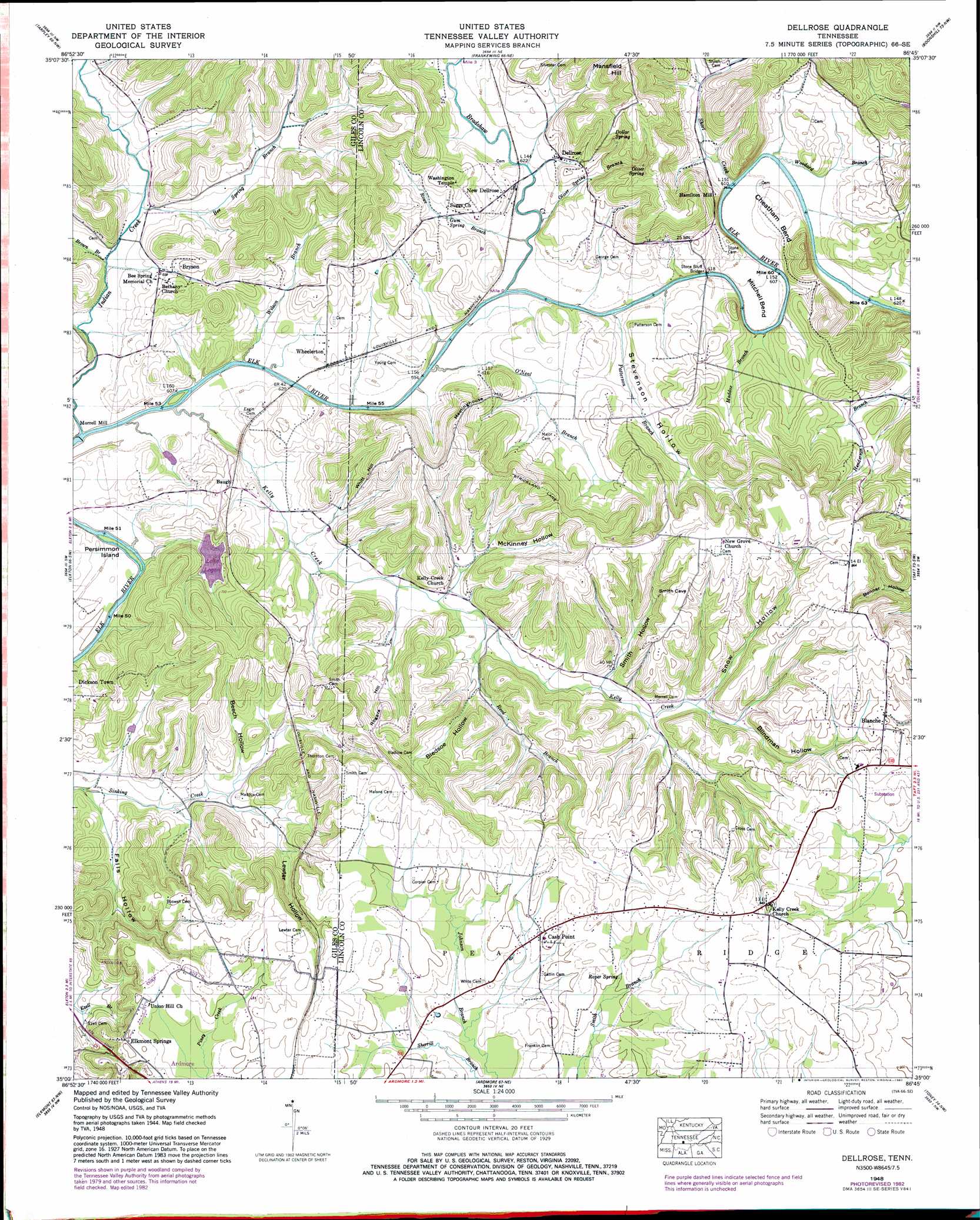
USGS Topo Quad 35086a7 - 1:24,000 scale
| Topo Map Name: | Dellrose |
| USGS Topo Quad ID: | 35086a7 |
| Print Size: | ca. 21 1/4" wide x 27" high |
| Southeast Coordinates: | 35° N latitude / 86.75° W longitude |
| Map Center Coordinates: | 35.0625° N latitude / 86.8125° W longitude |
| U.S. State: | TN |
| Filename: | o35086a7.jpg |
| Download Map JPG Image: | Dellrose topo map 1:24,000 scale |
| Map Type: | Topographic |
| Topo Series: | 7.5´ |
| Map Scale: | 1:24,000 |
| Source of Map Images: | United States Geological Survey (USGS) |
| Alternate Map Versions: |
Dellrose TN 1936 Download PDF Buy paper map Dellrose TN 1948, updated 1982 Download PDF Buy paper map Dellrose TN 1951 Download PDF Buy paper map Dellrose TN 1951 Download PDF Buy paper map Dellrose TN 1951, updated 1967 Download PDF Buy paper map Dellrose TN 2010 Download PDF Buy paper map Dellrose TN 2013 Download PDF Buy paper map Dellrose TN 2016 Download PDF Buy paper map |
1:24,000 Topo Quads surrounding Dellrose
Milky Way |
Brick Church |
Cornersville |
Petersburg |
Belleville |
Pulaski |
Tarpley |
Frankewing |
Boonshill |
Fayetteville |
Aspen Hill |
Elkton |
Dellrose |
Taft |
Lincoln |
Salem |
Elkmont |
Ardmore |
Toney |
Fisk |
Ripley |
Athens |
Capshaw |
Jeff |
Meridianville |
> Back to 35086a1 at 1:100,000 scale
> Back to 35086a1 at 1:250,000 scale
> Back to U.S. Topo Maps home
Dellrose topo map: Gazetteer
Dellrose: Bends
Cheatham Bend elevation 193m 633′Mitchell Bend elevation 188m 616′
Dellrose: Bridges
Stone Bluff Bridge elevation 183m 600′Dellrose: Dams
Lake Logan Dam elevation 204m 669′Dellrose: Islands
Crowley Island elevation 183m 600′Persimmon Island elevation 179m 587′
Dellrose: Populated Places
Baugh elevation 207m 679′Blanche elevation 276m 905′
Bryson elevation 203m 666′
Cash Point elevation 274m 898′
Dellrose elevation 205m 672′
Elkmont Springs elevation 274m 898′
Hamilton Mill elevation 210m 688′
Morrell Mill elevation 183m 600′
New Dellrose elevation 190m 623′
Wheelerton elevation 190m 623′
Dellrose: Post Offices
Dellrose Post Office elevation 194m 636′Dellrose: Reservoirs
Lake Logan elevation 204m 669′Dellrose: Springs
Dollar Spring elevation 248m 813′Elkmont Springs elevation 248m 813′
Gum Spring elevation 189m 620′
Oliver Spring elevation 235m 770′
Roper Spring elevation 275m 902′
Dellrose: Streams
Bee Spring Branch elevation 189m 620′Bradshaw Creek elevation 183m 600′
Brown Branch elevation 186m 610′
Indian Creek elevation 182m 597′
Kelly Creek elevation 183m 600′
King Branch elevation 183m 600′
Maddox Branch elevation 183m 600′
Mitchell Spring Branch elevation 188m 616′
Oliver Spring Branch elevation 185m 606′
O'Neal Branch elevation 183m 600′
Patterson Branch elevation 183m 600′
Reed Branch elevation 203m 666′
Rowe Branch elevation 184m 603′
Short Creek elevation 185m 606′
Wilson Branch elevation 183m 600′
Woodard Branch elevation 186m 610′
Dellrose: Summits
Meetinghouse Hill elevation 217m 711′Rogers Hill elevation 259m 849′
Whitt Hill elevation 255m 836′
Dellrose: Tunnels
Luda Tunnel elevation 278m 912′Dellrose: Valleys
Beech Hollow elevation 208m 682′Bledsoe Hollow elevation 207m 679′
Blindman Hollow elevation 231m 757′
Falls Hollow elevation 188m 616′
Lewter Hollow elevation 219m 718′
McKinney Hollow elevation 203m 666′
Millville Hollow elevation 196m 643′
Smith Hollow elevation 219m 718′
Snow Hollow elevation 225m 738′
Stevenson Hollow elevation 183m 600′
Dellrose digital topo map on disk
Buy this Dellrose topo map showing relief, roads, GPS coordinates and other geographical features, as a high-resolution digital map file on DVD: