Boonshill Topo Map Tennessee
To zoom in, hover over the map of Boonshill
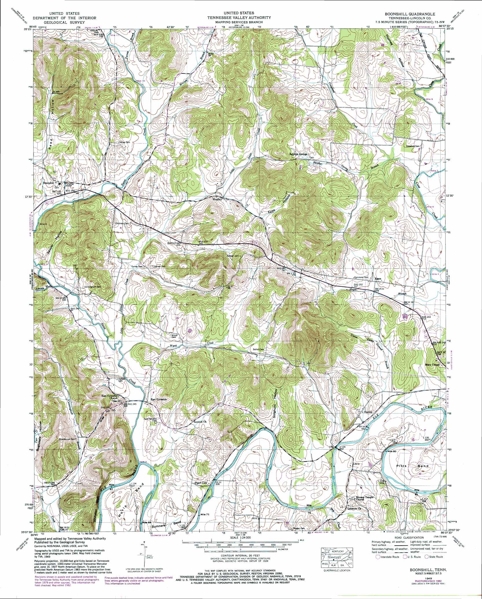
USGS Topo Quad 35086b6 - 1:24,000 scale
| Topo Map Name: | Boonshill |
| USGS Topo Quad ID: | 35086b6 |
| Print Size: | ca. 21 1/4" wide x 27" high |
| Southeast Coordinates: | 35.125° N latitude / 86.625° W longitude |
| Map Center Coordinates: | 35.1875° N latitude / 86.6875° W longitude |
| U.S. State: | TN |
| Filename: | o35086b6.jpg |
| Download Map JPG Image: | Boonshill topo map 1:24,000 scale |
| Map Type: | Topographic |
| Topo Series: | 7.5´ |
| Map Scale: | 1:24,000 |
| Source of Map Images: | United States Geological Survey (USGS) |
| Alternate Map Versions: |
Boonshill TN 1936 Download PDF Buy paper map Boonshill TN 1949, updated 1982 Download PDF Buy paper map Boonshill TN 1951 Download PDF Buy paper map Boonshill TN 1951, updated 1996 Download PDF Buy paper map Boonshill TN 2010 Download PDF Buy paper map Boonshill TN 2013 Download PDF Buy paper map Boonshill TN 2016 Download PDF Buy paper map |
1:24,000 Topo Quads surrounding Boonshill
Campbells Station |
Lewisburg |
Belfast |
Bedford |
Shelbyville |
Brick Church |
Cornersville |
Petersburg |
Belleville |
Lynchburg West |
Tarpley |
Frankewing |
Boonshill |
Fayetteville |
Mulberry |
Elkton |
Dellrose |
Taft |
Lincoln |
Flintville |
Elkmont |
Ardmore |
Toney |
Fisk |
New Market |
> Back to 35086a1 at 1:100,000 scale
> Back to 35086a1 at 1:250,000 scale
> Back to U.S. Topo Maps home
Boonshill topo map: Gazetteer
Boonshill: Bends
Hovis Bend elevation 200m 656′Pitts Bend elevation 206m 675′
Boonshill: Cliffs
Whitaker Bluff elevation 220m 721′Boonshill: Populated Places
Boonshill elevation 216m 708′East Cyruston elevation 197m 646′
Egam elevation 212m 695′
Harms elevation 200m 656′
Hughey elevation 219m 718′
Pearl City elevation 192m 629′
Sulphur Springs elevation 239m 784′
Boonshill: Ridges
Hickory Ridge elevation 249m 816′Boonshill: Streams
Craighead Creek elevation 204m 669′Cunningham Branch elevation 194m 636′
Dry Creek elevation 194m 636′
Johnson Branch elevation 195m 639′
Little Swan Creek elevation 191m 626′
Morton Branch elevation 210m 688′
Sulphur Spring Branch elevation 206m 675′
Swan Creek elevation 188m 616′
Turney Branch elevation 211m 692′
Union Camp Ground Branch elevation 190m 623′
Wyatt Creek elevation 191m 626′
Boonshill: Summits
Sugg Hill elevation 261m 856′Boonshill: Valleys
Barnes Hollow elevation 196m 643′Bugtussle Hollow elevation 204m 669′
Cunningham Hollow elevation 201m 659′
Epps Hollow elevation 225m 738′
Gunner Hollow elevation 193m 633′
Sawyer Hollow elevation 200m 656′
Sorghum Hollow elevation 194m 636′
Thomas Hollow elevation 212m 695′
Boonshill digital topo map on disk
Buy this Boonshill topo map showing relief, roads, GPS coordinates and other geographical features, as a high-resolution digital map file on DVD: