Lynchburg East Topo Map Tennessee
To zoom in, hover over the map of Lynchburg East
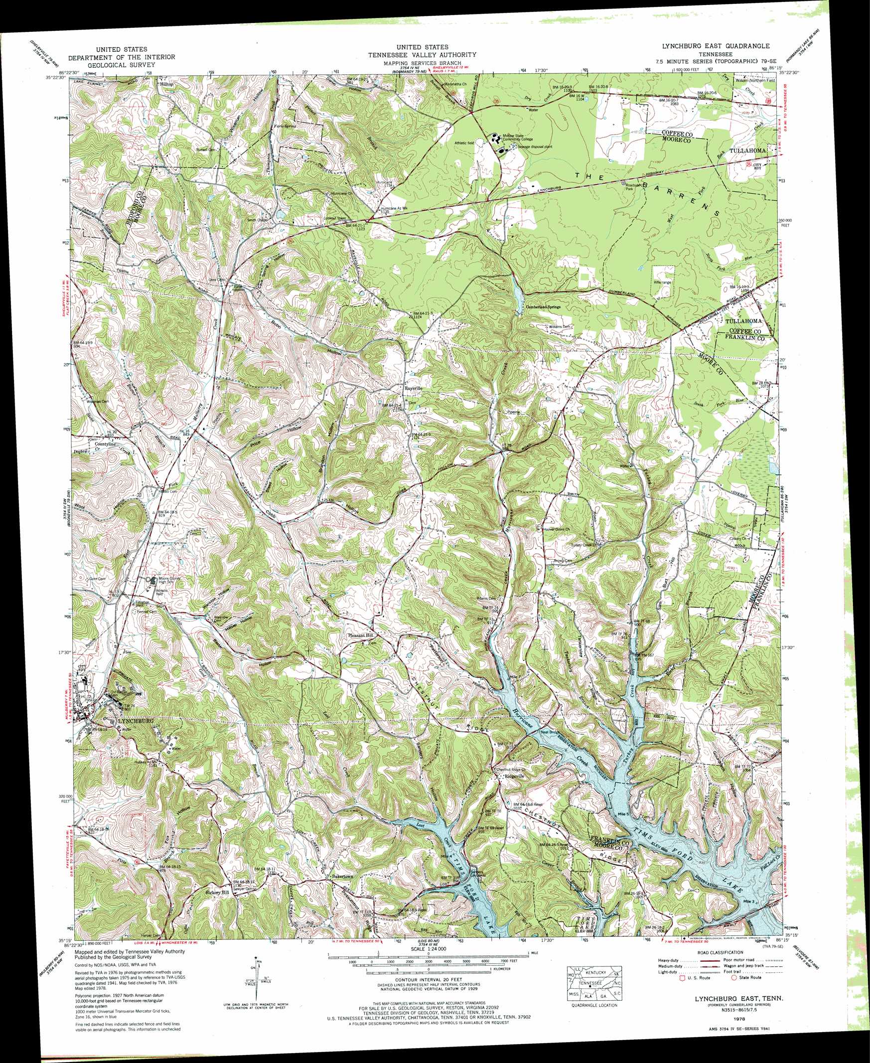
USGS Topo Quad 35086c3 - 1:24,000 scale
| Topo Map Name: | Lynchburg East |
| USGS Topo Quad ID: | 35086c3 |
| Print Size: | ca. 21 1/4" wide x 27" high |
| Southeast Coordinates: | 35.25° N latitude / 86.25° W longitude |
| Map Center Coordinates: | 35.3125° N latitude / 86.3125° W longitude |
| U.S. State: | TN |
| Filename: | o35086c3.jpg |
| Download Map JPG Image: | Lynchburg East topo map 1:24,000 scale |
| Map Type: | Topographic |
| Topo Series: | 7.5´ |
| Map Scale: | 1:24,000 |
| Source of Map Images: | United States Geological Survey (USGS) |
| Alternate Map Versions: |
Cumberland Springs TN 1936 Download PDF Buy paper map Cumberland Springs TN 1941, updated 1943 Download PDF Buy paper map Cumberland Springs TN 1941, updated 1943 Download PDF Buy paper map Cumberland Springs TN 1941, updated 1957 Download PDF Buy paper map Cumberland Springs TN 1941, updated 1972 Download PDF Buy paper map Cumberland Springs TN 1941, updated 1975 Download PDF Buy paper map Lynchburg East TN 1978, updated 1978 Download PDF Buy paper map Lynchburg East TN 2010 Download PDF Buy paper map Lynchburg East TN 2013 Download PDF Buy paper map Lynchburg East TN 2016 Download PDF Buy paper map |
1:24,000 Topo Quads surrounding Lynchburg East
Unionville |
Deason |
Wartrace |
Noah |
Fredonia |
Bedford |
Shelbyville |
Normandy |
Normandy Lake |
Manchester |
Belleville |
Lynchburg West |
Lynchburg East |
Tullahoma |
Capitol Hill |
Fayetteville |
Mulberry |
Lois |
Belvidere |
Winchester |
Lincoln |
Flintville |
Huntland |
Beans Creek |
Pitcher Ridge |
> Back to 35086a1 at 1:100,000 scale
> Back to 35086a1 at 1:250,000 scale
> Back to U.S. Topo Maps home
Lynchburg East topo map: Gazetteer
Lynchburg East: Bridges
Awalt Bridge elevation 271m 889′Neal Bridge elevation 271m 889′
Sanders Causeway elevation 271m 889′
Lynchburg East: Dams
Cumberland Springs Lake Dam elevation 299m 980′Lynchburg East: Parks
Lost Creek Public Use Area elevation 276m 905′Turkey Creek Public Use Area elevation 300m 984′
Lynchburg East: Populated Places
Awalt (historical) elevation 271m 889′Bakertown elevation 335m 1099′
Countyline elevation 252m 826′
Cumberland Springs elevation 309m 1013′
Hickory Hill elevation 342m 1122′
Hilltop elevation 351m 1151′
Lynchburg elevation 245m 803′
Pleasant Hill elevation 317m 1040′
Raysville elevation 341m 1118′
Ridgeville elevation 326m 1069′
Turkey Creek elevation 298m 977′
Lynchburg East: Post Offices
Cumberland Springs Post Office (historical) elevation 309m 1013′Lynchburg East: Reservoirs
Cumberland Springs Lake elevation 299m 980′Lynchburg East: Ridges
Chestnut Ridge elevation 332m 1089′Chestnut Ridge elevation 308m 1010′
Possumtrot Ridge elevation 315m 1033′
Tankersley Ridge elevation 321m 1053′
Lynchburg East: Springs
Faris Spring elevation 279m 915′Lynchburg East: Streams
Baxter Branch elevation 252m 826′Bobo Creek elevation 270m 885′
Dogtail Creek elevation 252m 826′
Dry Creek elevation 323m 1059′
Fall Lick Creek elevation 271m 889′
Good Branch elevation 239m 784′
Prince Branch elevation 271m 889′
Rocky Branch elevation 271m 889′
Stone Creek elevation 246m 807′
Tankersley Branch elevation 271m 889′
Turkey Creek elevation 271m 889′
Lynchburg East: Summits
Sam Burt Hill elevation 327m 1072′Lynchburg East: Valleys
Baxter Hollow elevation 259m 849′Bedford Hollow elevation 272m 892′
Bobo Hollow elevation 270m 885′
Brandon Hollow elevation 277m 908′
Cave Spring Hollow elevation 273m 895′
Cobb Hollow elevation 257m 843′
Fox Hollow elevation 261m 856′
Gourdneck Hollow elevation 271m 889′
Hatchett Hollow elevation 271m 889′
Millsap Hollow elevation 268m 879′
Patterson Hollow elevation 271m 889′
Price Hollow elevation 260m 853′
Rittle Hollow elevation 268m 879′
Sanders Hollow elevation 271m 889′
Steed Hollow elevation 272m 892′
Stillhouse Hollow elevation 246m 807′
Wanslow Hollow elevation 261m 856′
Wiseman Hollow elevation 273m 895′
Wool Hollow elevation 255m 836′
Lynchburg East digital topo map on disk
Buy this Lynchburg East topo map showing relief, roads, GPS coordinates and other geographical features, as a high-resolution digital map file on DVD: