Manchester Topo Map Tennessee
To zoom in, hover over the map of Manchester
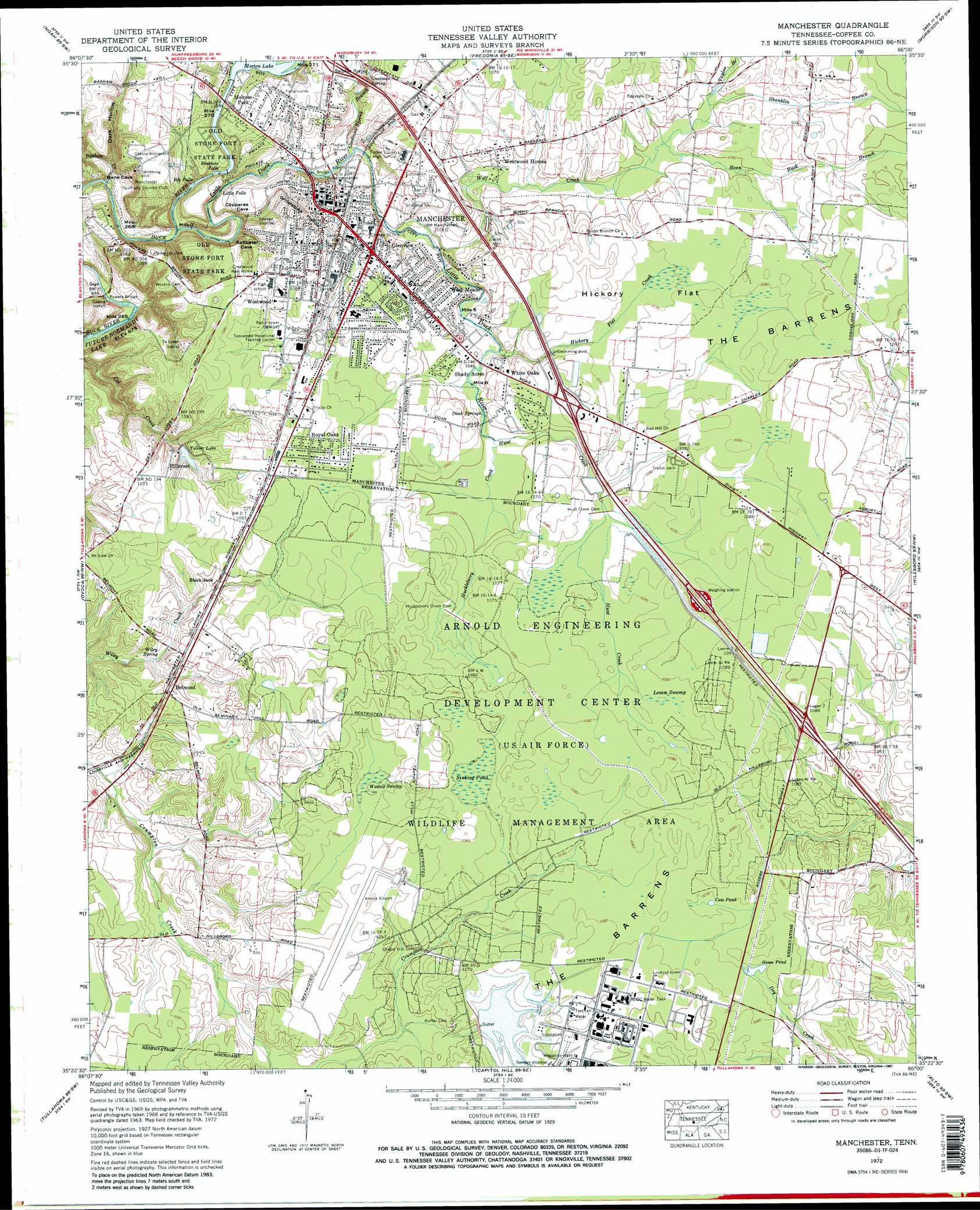
USGS Topo Quad 35086d1 - 1:24,000 scale
| Topo Map Name: | Manchester |
| USGS Topo Quad ID: | 35086d1 |
| Print Size: | ca. 21 1/4" wide x 27" high |
| Southeast Coordinates: | 35.375° N latitude / 86° W longitude |
| Map Center Coordinates: | 35.4375° N latitude / 86.0625° W longitude |
| U.S. State: | TN |
| Filename: | o35086d1.jpg |
| Download Map JPG Image: | Manchester topo map 1:24,000 scale |
| Map Type: | Topographic |
| Topo Series: | 7.5´ |
| Map Scale: | 1:24,000 |
| Source of Map Images: | United States Geological Survey (USGS) |
| Alternate Map Versions: |
Manchester TN 1936 Download PDF Buy paper map Manchester TN 1941, updated 1943 Download PDF Buy paper map Manchester TN 1941, updated 1943 Download PDF Buy paper map Manchester TN 1941, updated 1958 Download PDF Buy paper map Manchester TN 1963, updated 1965 Download PDF Buy paper map Manchester TN 1972, updated 1974 Download PDF Buy paper map Manchester TN 1972, updated 1987 Download PDF Buy paper map Manchester TN 1972, updated 1987 Download PDF Buy paper map Manchester TN 1972, updated 1993 Download PDF Buy paper map Manchester TN 2010 Download PDF Buy paper map Manchester TN 2013 Download PDF Buy paper map Manchester TN 2016 Download PDF Buy paper map |
1:24,000 Topo Quads surrounding Manchester
Webbs Jungle |
Beechgrove |
Hollow Springs |
Centertown |
Mcminnville |
Wartrace |
Noah |
Fredonia |
Morrison |
Viola |
Normandy |
Normandy Lake |
Manchester |
Hillsboro |
Cane Hollow |
Lynchburg East |
Tullahoma |
Capitol Hill |
Alto |
Burrow Cove |
Lois |
Belvidere |
Winchester |
Sewanee |
Monteagle |
> Back to 35086a1 at 1:100,000 scale
> Back to 35086a1 at 1:250,000 scale
> Back to U.S. Topo Maps home
Manchester topo map: Gazetteer
Manchester: Airports
Arnold AFS Airport elevation 323m 1059′Manchester: Bridges
Jail Bridge elevation 298m 977′Powers Bridge elevation 269m 882′
Manchester: Crossings
Interchange 110 elevation 310m 1017′Interchange 114 elevation 328m 1076′
Interchange 117 elevation 329m 1079′
Manchester: Dams
AEDC Retention Reservoir Dam elevation 325m 1066′Huckleberry Creek Dam elevation 324m 1062′
Hunt Creek Dam elevation 323m 1059′
Morton Dam elevation 303m 994′
Toliver Lake Dam elevation 312m 1023′
Manchester: Falls
Big Falls elevation 275m 902′Bluehole Falls elevation 292m 958′
Little Falls elevation 287m 941′
Manchester: Flats
Hickory Flat elevation 326m 1069′Manchester: Lakes
Cow Pond elevation 326m 1069′Goose Pond elevation 326m 1069′
Manchester: Parks
Old Stone Fort State Park elevation 303m 994′Manchester: Populated Places
Belmont elevation 320m 1049′Black Jack elevation 320m 1049′
Dixie (historical) elevation 328m 1076′
Glenview elevation 322m 1056′
Green Acres Mobile Home Park elevation 323m 1059′
Hillcrest elevation 320m 1049′
Manchester elevation 323m 1059′
Melrose Park elevation 312m 1023′
Ragsdale Road Mobile Home Park elevation 331m 1085′
Royal Oaks elevation 333m 1092′
Shady Acres elevation 320m 1049′
Shady Grove Mobile Home Park elevation 329m 1079′
Stacey Anns Mobile Home Park elevation 331m 1085′
Town And Country Mobile Home Park elevation 323m 1059′
West Meade elevation 322m 1056′
Westwood elevation 330m 1082′
Westwood Homes elevation 320m 1049′
White Oaks elevation 324m 1062′
Manchester: Post Offices
Manchester Post Office elevation 321m 1053′Manchester: Reservoirs
AEDC Retention Reservoir elevation 325m 1066′AEDC Water Tank elevation 333m 1092′
Morton Lake elevation 303m 994′
Toliver Lake elevation 312m 1023′
Manchester: Springs
Allison Spring elevation 322m 1056′Doak Springs elevation 317m 1040′
Goodman Spring elevation 309m 1013′
Sulphur Spring elevation 320m 1049′
Wiley Spring elevation 308m 1010′
Manchester: Streams
Bashaw Creek elevation 274m 898′Goodman Spring Branch elevation 301m 987′
Hickory Flat Creek elevation 314m 1030′
Huckleberry Creek elevation 317m 1040′
Hunt Creek elevation 317m 1040′
Little Duck River elevation 275m 902′
Roan Buck Branch elevation 318m 1043′
Shanklin Branch elevation 319m 1046′
Taylor Branch elevation 318m 1043′
Wolf Creek elevation 305m 1000′
Manchester: Swamps
Goose Pond Swamp (historical) elevation 326m 1069′Lemm Swamp elevation 328m 1076′
Sinking Pond elevation 321m 1053′
Westall Swamp elevation 323m 1059′
Manchester: Valleys
Dark Hollow elevation 283m 928′Grindstone Hollow elevation 277m 908′
Manchester digital topo map on disk
Buy this Manchester topo map showing relief, roads, GPS coordinates and other geographical features, as a high-resolution digital map file on DVD: