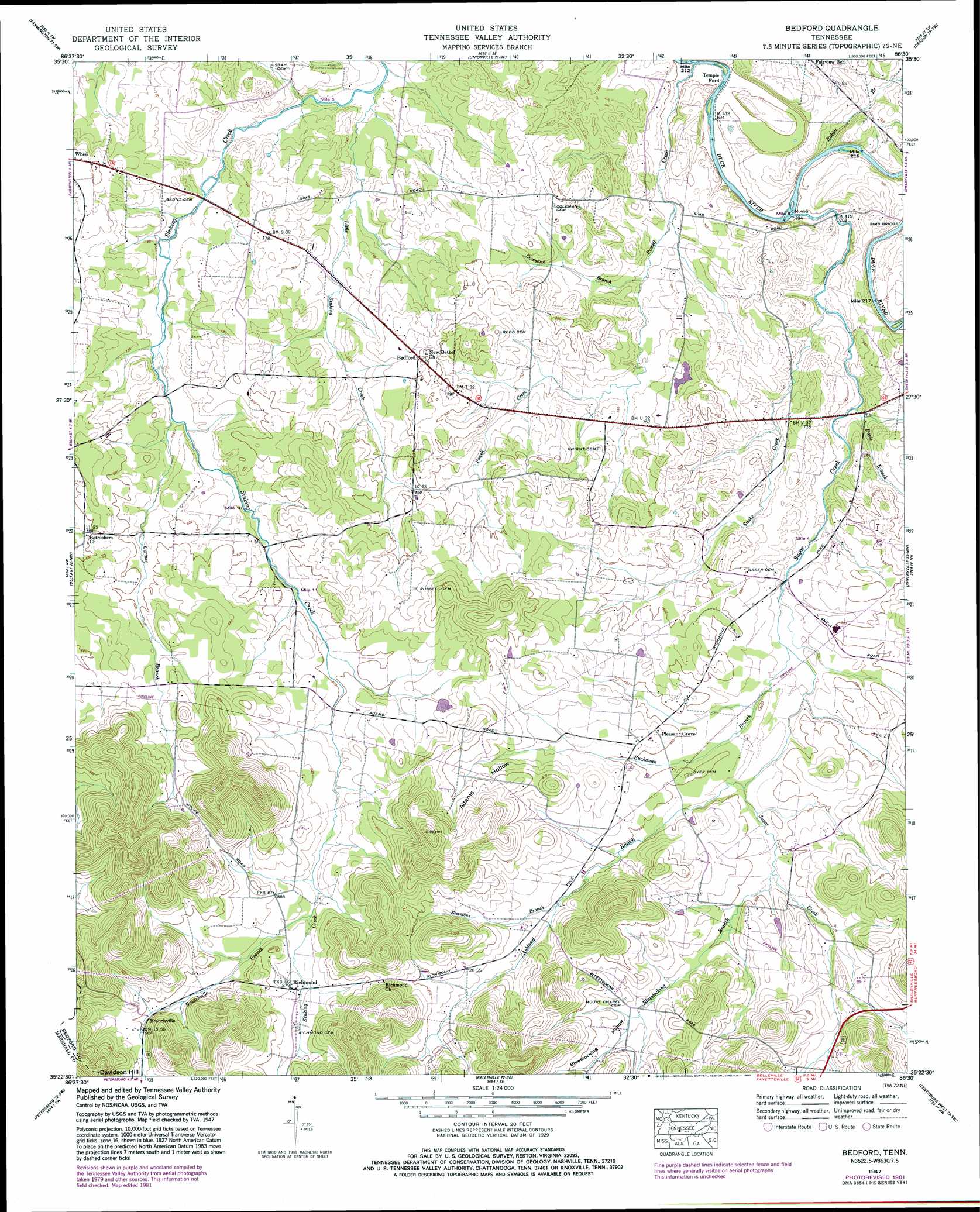
Bedford Topo Map Tennessee
To zoom in, hover over the map of Bedford
USGS Topo Quad 35086d5 - 1:24,000 scale
| Topo Map Name: | Bedford |
| USGS Topo Quad ID: | 35086d5 |
| Print Size: | ca. 21 1/4" wide x 27" high |
| Southeast Coordinates: | 35.375° N latitude / 86.5° W longitude |
| Map Center Coordinates: | 35.4375° N latitude / 86.5625° W longitude |
| U.S. State: | TN |
| Filename: | o35086d5.jpg |
| Download Map JPG Image: | Bedford topo map 1:24,000 scale |
| Map Type: | Topographic |
| Topo Series: | 7.5´ |
| Map Scale: | 1:24,000 |
| Source of Map Images: | United States Geological Survey (USGS) |
| Alternate Map Versions: |
Bedford TN 1936 Download PDF Buy paper map Bedford TN 1947, updated 1948 Download PDF Buy paper map Bedford TN 1947, updated 1965 Download PDF Buy paper map Bedford TN 1947, updated 1977 Download PDF Buy paper map Bedford TN 1947, updated 1982 Download PDF Buy paper map Bedford TN 2010 Download PDF Buy paper map Bedford TN 2013 Download PDF Buy paper map Bedford TN 2016 Download PDF Buy paper map |
1:24,000 Topo Quads surrounding Bedford
Rally Hill |
Chapel Hill |
Rover |
Fosterville |
Webbs Jungle |
Verona |
Farmington |
Unionville |
Deason |
Wartrace |
Lewisburg |
Belfast |
Bedford |
Shelbyville |
Normandy |
Cornersville |
Petersburg |
Belleville |
Lynchburg West |
Lynchburg East |
Frankewing |
Boonshill |
Fayetteville |
Mulberry |
Lois |
> Back to 35086a1 at 1:100,000 scale
> Back to 35086a1 at 1:250,000 scale
> Back to U.S. Topo Maps home
Bedford topo map: Gazetteer
Bedford: Crossings
Temple Ford elevation 206m 675′Bedford: Populated Places
Bedford elevation 242m 793′Branchville elevation 272m 892′
Pleasant Grove elevation 251m 823′
Richmond elevation 266m 872′
Bedford: Streams
Ashland Branch elevation 235m 770′Bluestocking Branch elevation 240m 787′
Branchville Branch elevation 254m 833′
Buchanan Branch elevation 230m 754′
Comstock Branch elevation 219m 718′
Cortner Branch elevation 229m 751′
Davis Branch elevation 218m 715′
Little Sinking Creek elevation 216m 708′
Powell Creek elevation 205m 672′
Rabbit Branch elevation 210m 688′
Simmons Branch elevation 245m 803′
Snake Creek elevation 214m 702′
Sugar Creek elevation 207m 679′
Bedford: Valleys
Adams Hollow elevation 247m 810′Bluestocking Hollow elevation 279m 915′
Bedford digital topo map on disk
Buy this Bedford topo map showing relief, roads, GPS coordinates and other geographical features, as a high-resolution digital map file on DVD: