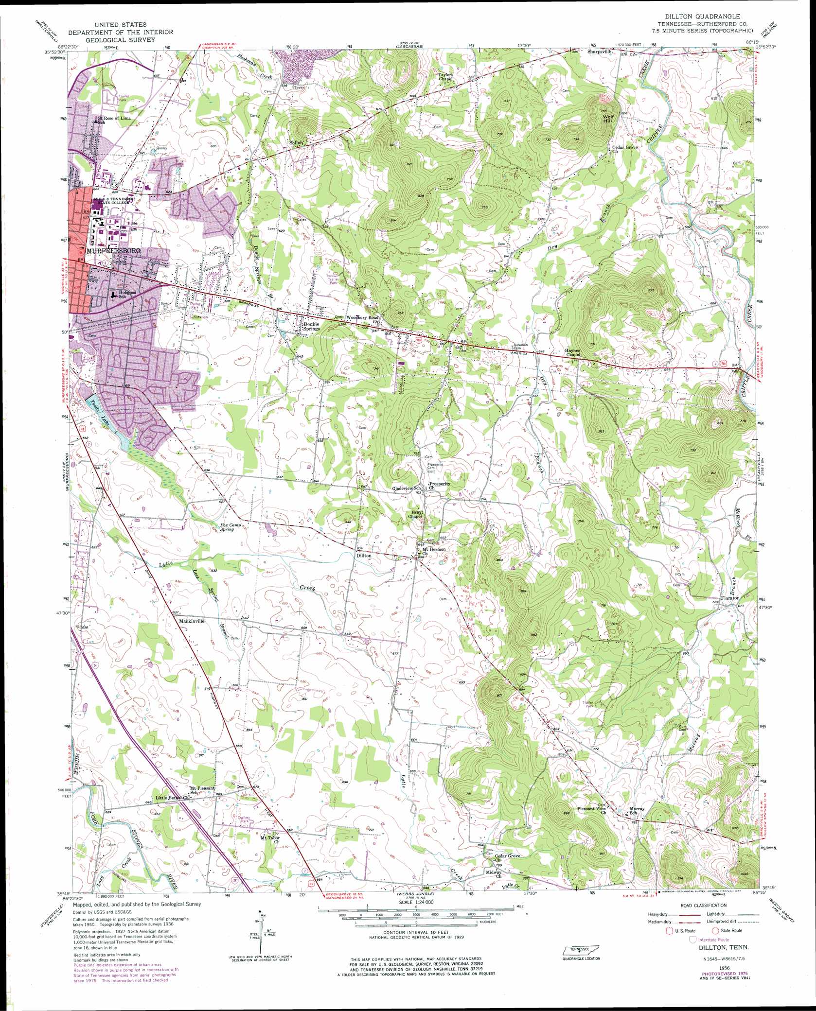
Dillton Topo Map Tennessee
To zoom in, hover over the map of Dillton
USGS Topo Quad 35086g3 - 1:24,000 scale
| Topo Map Name: | Dillton |
| USGS Topo Quad ID: | 35086g3 |
| Print Size: | ca. 21 1/4" wide x 27" high |
| Southeast Coordinates: | 35.75° N latitude / 86.25° W longitude |
| Map Center Coordinates: | 35.8125° N latitude / 86.3125° W longitude |
| U.S. State: | TN |
| Filename: | o35086g3.jpg |
| Download Map JPG Image: | Dillton topo map 1:24,000 scale |
| Map Type: | Topographic |
| Topo Series: | 7.5´ |
| Map Scale: | 1:24,000 |
| Source of Map Images: | United States Geological Survey (USGS) |
| Alternate Map Versions: |
Dillton TN 1956, updated 1957 Download PDF Buy paper map Dillton TN 1956, updated 1977 Download PDF Buy paper map Dillton TN 1956, updated 1977 Download PDF Buy paper map Dillton TN 2010 Download PDF Buy paper map Dillton TN 2013 Download PDF Buy paper map Dillton TN 2016 Download PDF Buy paper map |
1:24,000 Topo Quads surrounding Dillton
La Vergne |
Gladeville |
Vine |
Watertown |
Alexandria |
Smyrna |
Walterhill |
Lascassas |
Milton |
Auburntown |
Rockvale |
Murfreesboro |
Dillton |
Readyville |
Woodbury |
Rover |
Fosterville |
Webbs Jungle |
Beechgrove |
Hollow Springs |
Unionville |
Deason |
Wartrace |
Noah |
Fredonia |
> Back to 35086e1 at 1:100,000 scale
> Back to 35086a1 at 1:250,000 scale
> Back to U.S. Topo Maps home
Dillton topo map: Gazetteer
Dillton: Dams
Todds Lake Dam elevation 183m 600′Todds Lake Number Two Dam elevation 183m 600′
Dillton: Parks
Floyd Stadium elevation 192m 629′Jones Field elevation 192m 629′
Smith Baseball Field elevation 191m 626′
Dillton: Populated Places
Burns Place elevation 209m 685′Dillton elevation 194m 636′
Double Springs elevation 193m 633′
Floraton elevation 209m 685′
Fox Camp Meadows elevation 198m 649′
Greenbriar elevation 190m 623′
Kittrell Heights elevation 193m 633′
Lascassas Villa elevation 183m 600′
Lillard Farm Estates elevation 184m 603′
Mankinville elevation 192m 629′
McFarlin elevation 189m 620′
Mount Tabor elevation 204m 669′
Overall Acres elevation 204m 669′
Park Manor elevation 185m 606′
Pleasant View elevation 248m 813′
Quail Run elevation 186m 610′
Reidhurst elevation 192m 629′
Ridgecrest Acres elevation 202m 662′
Scotland Acres elevation 188m 616′
Sharpsville elevation 179m 587′
Shiloh elevation 210m 688′
Tulip Hill Estates elevation 193m 633′
Twin Springs elevation 195m 639′
Yearwood Addition elevation 188m 616′
Dillton: Reservoirs
Todds Lake elevation 183m 600′Todds Lake Number Two elevation 183m 600′
Dillton: Springs
Double Spring elevation 188m 616′Fox Camp Spring elevation 189m 620′
Dillton: Streams
Double Springs Branch elevation 183m 600′Dry Branch elevation 176m 577′
Lees Spring Branch elevation 188m 616′
Long Creek elevation 189m 620′
Murray Branch elevation 198m 649′
Dillton: Summits
Wolf Hill elevation 237m 777′Dillton digital topo map on disk
Buy this Dillton topo map showing relief, roads, GPS coordinates and other geographical features, as a high-resolution digital map file on DVD: