Bethesda Topo Map Tennessee
To zoom in, hover over the map of Bethesda
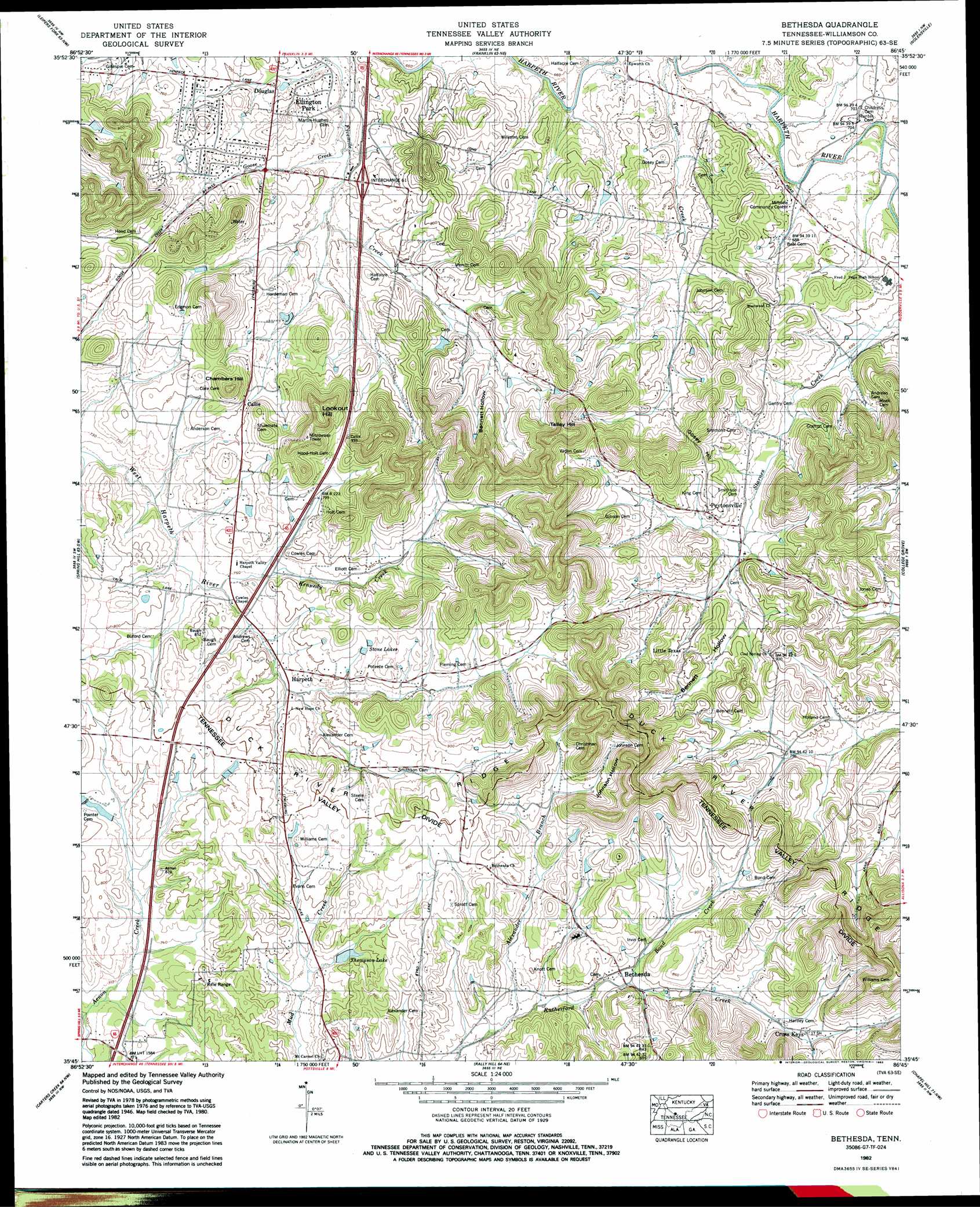
USGS Topo Quad 35086g7 - 1:24,000 scale
| Topo Map Name: | Bethesda |
| USGS Topo Quad ID: | 35086g7 |
| Print Size: | ca. 21 1/4" wide x 27" high |
| Southeast Coordinates: | 35.75° N latitude / 86.75° W longitude |
| Map Center Coordinates: | 35.8125° N latitude / 86.8125° W longitude |
| U.S. State: | TN |
| Filename: | o35086g7.jpg |
| Download Map JPG Image: | Bethesda topo map 1:24,000 scale |
| Map Type: | Topographic |
| Topo Series: | 7.5´ |
| Map Scale: | 1:24,000 |
| Source of Map Images: | United States Geological Survey (USGS) |
| Alternate Map Versions: |
Bethesda TN 1936, updated 1969 Download PDF Buy paper map Bethesda TN 1946, updated 1974 Download PDF Buy paper map Bethesda TN 1949 Download PDF Buy paper map Bethesda TN 1949, updated 1969 Download PDF Buy paper map Bethesda TN 1982, updated 1983 Download PDF Buy paper map Bethesda TN 1982, updated 1983 Download PDF Buy paper map Bethesda TN 2010 Download PDF Buy paper map Bethesda TN 2013 Download PDF Buy paper map Bethesda TN 2016 Download PDF Buy paper map |
1:24,000 Topo Quads surrounding Bethesda
Kingston Springs |
Bellevue |
Oak Hill |
Antioch |
La Vergne |
Fairview |
Leipers Fork |
Franklin |
Nolensville |
Smyrna |
Theta |
Spring Hill |
Bethesda |
College Grove |
Rockvale |
Godwin |
Carters Creek |
Rally Hill |
Chapel Hill |
Rover |
Columbia |
Glendale |
Verona |
Farmington |
Unionville |
> Back to 35086e1 at 1:100,000 scale
> Back to 35086a1 at 1:250,000 scale
> Back to U.S. Topo Maps home
Bethesda topo map: Gazetteer
Bethesda: Crossings
Interchange 61 elevation 219m 718′Bethesda: Dams
Thompson Lake Dam elevation 231m 757′Bethesda: Populated Places
Bethesda elevation 243m 797′Callie elevation 247m 810′
Douglas elevation 208m 682′
Ellington Park elevation 202m 662′
Epworth elevation 201m 659′
Green Valley Estates elevation 240m 787′
Harpeth elevation 233m 764′
Heatherwood Hills elevation 248m 813′
Little Texas elevation 261m 856′
Peytonsville elevation 241m 790′
Springview elevation 222m 728′
Bethesda: Reservoirs
Stone Lakes elevation 249m 816′Thompson Lake elevation 231m 757′
Bethesda: Ridges
Duck River Ridge elevation 273m 895′Bethesda: Streams
Alexander Branch elevation 230m 754′Bond Creek elevation 238m 780′
Goose Creek elevation 202m 662′
Kennedy Creek elevation 225m 738′
West Fork Aenon Creek elevation 213m 698′
Bethesda: Summits
Chambers Hill elevation 320m 1049′Gosey Hill elevation 263m 862′
Lookout Hill elevation 337m 1105′
Talley Hill elevation 348m 1141′
Bethesda: Valleys
Bennett Hollow elevation 234m 767′Jackson Hollow elevation 249m 816′
Johnson Hollow elevation 260m 853′
Bethesda digital topo map on disk
Buy this Bethesda topo map showing relief, roads, GPS coordinates and other geographical features, as a high-resolution digital map file on DVD: