Auburntown Topo Map Tennessee
To zoom in, hover over the map of Auburntown
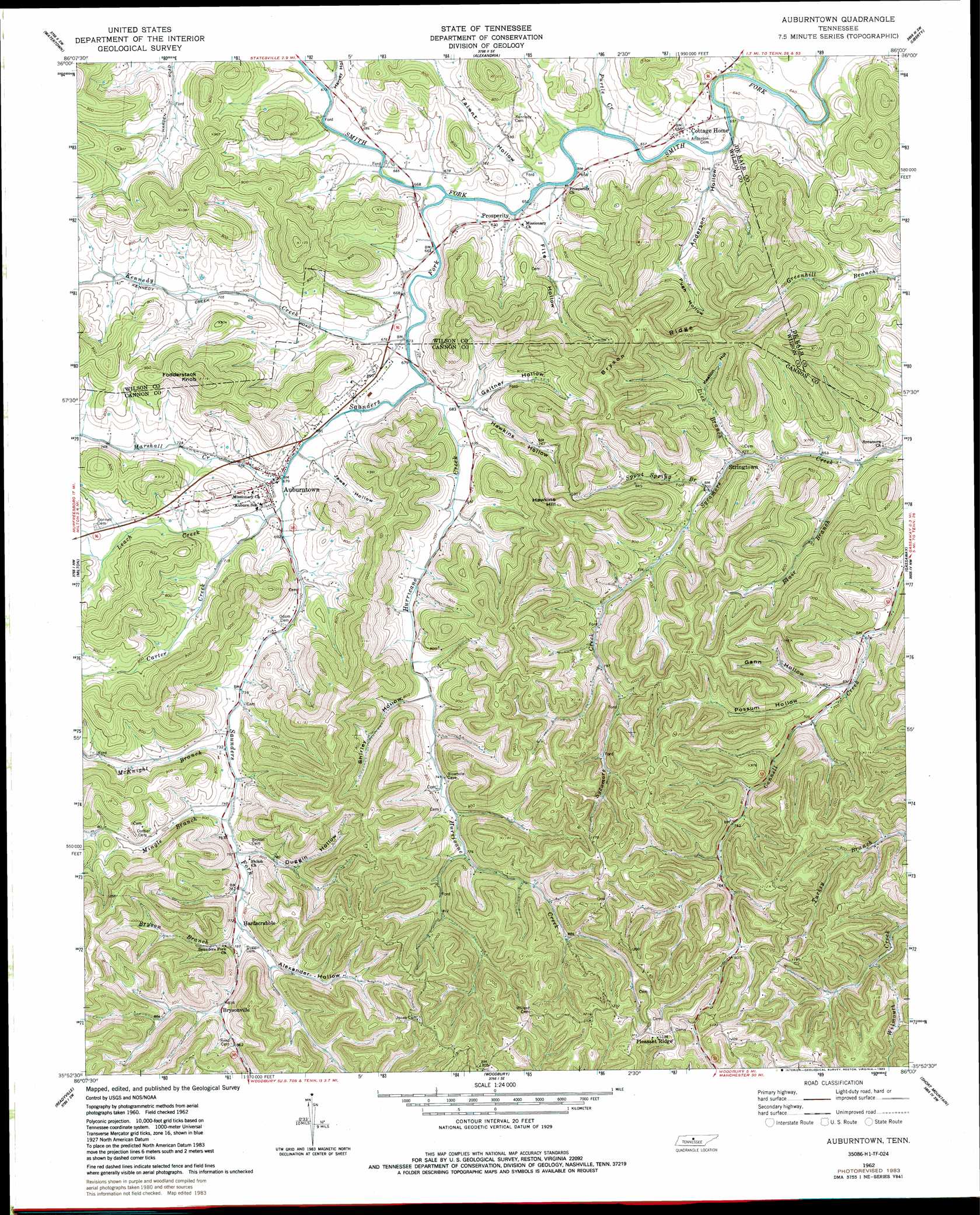
USGS Topo Quad 35086h1 - 1:24,000 scale
| Topo Map Name: | Auburntown |
| USGS Topo Quad ID: | 35086h1 |
| Print Size: | ca. 21 1/4" wide x 27" high |
| Southeast Coordinates: | 35.875° N latitude / 86° W longitude |
| Map Center Coordinates: | 35.9375° N latitude / 86.0625° W longitude |
| U.S. State: | TN |
| Filename: | o35086h1.jpg |
| Download Map JPG Image: | Auburntown topo map 1:24,000 scale |
| Map Type: | Topographic |
| Topo Series: | 7.5´ |
| Map Scale: | 1:24,000 |
| Source of Map Images: | United States Geological Survey (USGS) |
| Alternate Map Versions: |
Auburntown TN 1962, updated 1963 Download PDF Buy paper map Auburntown TN 1962, updated 1980 Download PDF Buy paper map Auburntown TN 1962, updated 1983 Download PDF Buy paper map Auburntown TN 2010 Download PDF Buy paper map Auburntown TN 2013 Download PDF Buy paper map Auburntown TN 2016 Download PDF Buy paper map |
1:24,000 Topo Quads surrounding Auburntown
Lebanon |
Shop Springs |
New Middleton |
Gordonsville |
Buffalo Valley |
Vine |
Watertown |
Alexandria |
Liberty |
Center Hill Dam |
Lascassas |
Milton |
Auburntown |
Gassaway |
Smithville |
Dillton |
Readyville |
Woodbury |
Short Mountain |
Dibrell |
Webbs Jungle |
Beechgrove |
Hollow Springs |
Centertown |
Mcminnville |
> Back to 35086e1 at 1:100,000 scale
> Back to 35086a1 at 1:250,000 scale
> Back to U.S. Topo Maps home
Auburntown topo map: Gazetteer
Auburntown: Populated Places
Auburntown elevation 218m 715′Brysonville elevation 251m 823′
Cottage Home elevation 201m 659′
Hardscrabble elevation 235m 770′
Jones Chapel (historical) elevation 355m 1164′
Pleasant Ridge elevation 374m 1227′
Prosperity elevation 201m 659′
Stringtown elevation 212m 695′
Auburntown: Ridges
Bryson Ridge elevation 313m 1026′Auburntown: Streams
Blair Branch elevation 195m 639′Bryson Branch elevation 237m 777′
Carter Creek elevation 208m 682′
Hurricane Creek elevation 200m 656′
Kennedy Creek elevation 201m 659′
Leach Creek elevation 209m 685′
Lick Branch elevation 205m 672′
Marshall Creek elevation 207m 679′
McKnight Branch elevation 221m 725′
Mingle Branch elevation 225m 738′
Purtle Creek elevation 197m 646′
Saunders Fork elevation 197m 646′
Spout Spring Branch elevation 212m 695′
Auburntown: Summits
Fodderstack Knob elevation 362m 1187′Hawkins Hill elevation 363m 1190′
Auburntown: Valleys
Alexander Hollow elevation 235m 770′Anderson Hollow elevation 193m 633′
Bryson Hollow elevation 236m 774′
Duggin Hollow elevation 230m 754′
Dutton Hollow elevation 228m 748′
Fite Hollow elevation 205m 672′
Gaither Hollow elevation 209m 685′
Gann Hollow elevation 210m 688′
Harvey Hollow elevation 206m 675′
Hawkins Hollow elevation 212m 695′
Higgins Hollow elevation 254m 833′
Jewel Hollow elevation 210m 688′
Keaton Hollow elevation 224m 734′
Possum Hollow elevation 210m 688′
Pugh Hollow elevation 216m 708′
Shirley Hollow elevation 225m 738′
Smith Hollow elevation 300m 984′
Talent Hollow elevation 199m 652′
Auburntown digital topo map on disk
Buy this Auburntown topo map showing relief, roads, GPS coordinates and other geographical features, as a high-resolution digital map file on DVD: