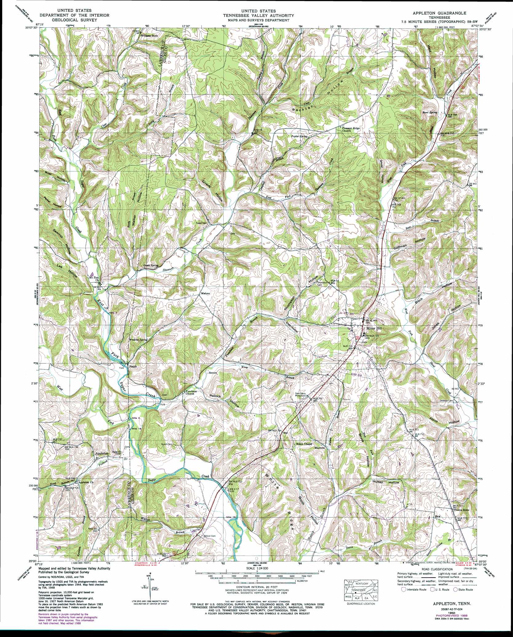
Appleton Topo Map Tennessee
To zoom in, hover over the map of Appleton
USGS Topo Quad 35087a2 - 1:24,000 scale
| Topo Map Name: | Appleton |
| USGS Topo Quad ID: | 35087a2 |
| Print Size: | ca. 21 1/4" wide x 27" high |
| Southeast Coordinates: | 35° N latitude / 87.125° W longitude |
| Map Center Coordinates: | 35.0625° N latitude / 87.1875° W longitude |
| U.S. State: | TN |
| Filename: | o35087a2.jpg |
| Download Map JPG Image: | Appleton topo map 1:24,000 scale |
| Map Type: | Topographic |
| Topo Series: | 7.5´ |
| Map Scale: | 1:24,000 |
| Source of Map Images: | United States Geological Survey (USGS) |
| Alternate Map Versions: |
Appleton TN 1936 Download PDF Buy paper map Appleton TN 1948 Download PDF Buy paper map Appleton TN 1950 Download PDF Buy paper map Appleton TN 1950, updated 1989 Download PDF Buy paper map Appleton TN 2010 Download PDF Buy paper map Appleton TN 2013 Download PDF Buy paper map Appleton TN 2016 Download PDF Buy paper map |
1:24,000 Topo Quads surrounding Appleton
Deerfield |
Ethridge |
Campbellsville |
Milky Way |
Brick Church |
Long Branch |
Lawrenceburg |
Bodenham |
Pulaski |
Tarpley |
Loretto |
Bonnertown |
Appleton |
Aspen Hill |
Elkton |
Center Hill |
Lexington |
Union Hill |
Salem |
Elkmont |
Wheeler Dam |
Rogersville |
Cairo |
Ripley |
Athens |
> Back to 35087a1 at 1:100,000 scale
> Back to 35086a1 at 1:250,000 scale
> Back to U.S. Topo Maps home
Appleton topo map: Gazetteer
Appleton: Populated Places
Appleton elevation 201m 659′Malone elevation 255m 836′
Marbuts elevation 217m 711′
Minor Hill elevation 270m 885′
Peach elevation 204m 669′
Sexton elevation 203m 666′
Appleton: Ridges
White Ridge elevation 252m 826′Appleton: Springs
Bevel Spring elevation 243m 797′Flippo Spring elevation 206m 675′
Green Spring elevation 217m 711′
Poplar Spring elevation 270m 885′
Watkins Spring elevation 215m 705′
Appleton: Streams
Appleton Branch elevation 201m 659′Appleton Branch elevation 201m 659′
Bass Branch elevation 219m 718′
Campbell Branch elevation 218m 715′
Cave Branch elevation 230m 754′
Clear Creek elevation 208m 682′
East Fork Hulsey Branch elevation 200m 656′
East Fork Shannon Creek elevation 215m 705′
East Fork Sugar Creek elevation 193m 633′
Hood Branch elevation 199m 652′
Long Branch elevation 210m 688′
New Hope Branch elevation 200m 656′
Pinhook Branch elevation 192m 629′
Puncheon Branch elevation 194m 636′
Reedy Branch elevation 203m 666′
Shannon Creek elevation 201m 659′
Tanyard Branch elevation 227m 744′
Turkey Branch elevation 228m 748′
Warren Branch elevation 189m 620′
Warren Branch elevation 189m 620′
West Fork Sugar Creek elevation 192m 629′
Wray Branch elevation 205m 672′
Yellow Branch elevation 237m 777′
Appleton: Summits
Minor Hill elevation 275m 902′Appleton: Valleys
Alsup Hollow elevation 205m 672′Black Hollow elevation 212m 695′
Booth Hollow elevation 200m 656′
Bruce Hollow elevation 207m 679′
Coffman Hollow elevation 227m 744′
Crab Hollow elevation 224m 734′
Givens Hollow elevation 217m 711′
Glover Hollow elevation 224m 734′
Hood Hollow elevation 204m 669′
Hulsey Hollow elevation 200m 656′
Jones Hollow elevation 210m 688′
Lee Hollow elevation 202m 662′
McGrew Hollow elevation 250m 820′
Miller Hollow elevation 210m 688′
Parker Hollow elevation 210m 688′
Pollock Hollow elevation 208m 682′
Rackley Hollow elevation 228m 748′
Sawmill Hollow elevation 208m 682′
Thompson Hollow elevation 226m 741′
Walker Hollow elevation 203m 666′
Warren Hollow elevation 197m 646′
West Hollow elevation 241m 790′
Appleton digital topo map on disk
Buy this Appleton topo map showing relief, roads, GPS coordinates and other geographical features, as a high-resolution digital map file on DVD: