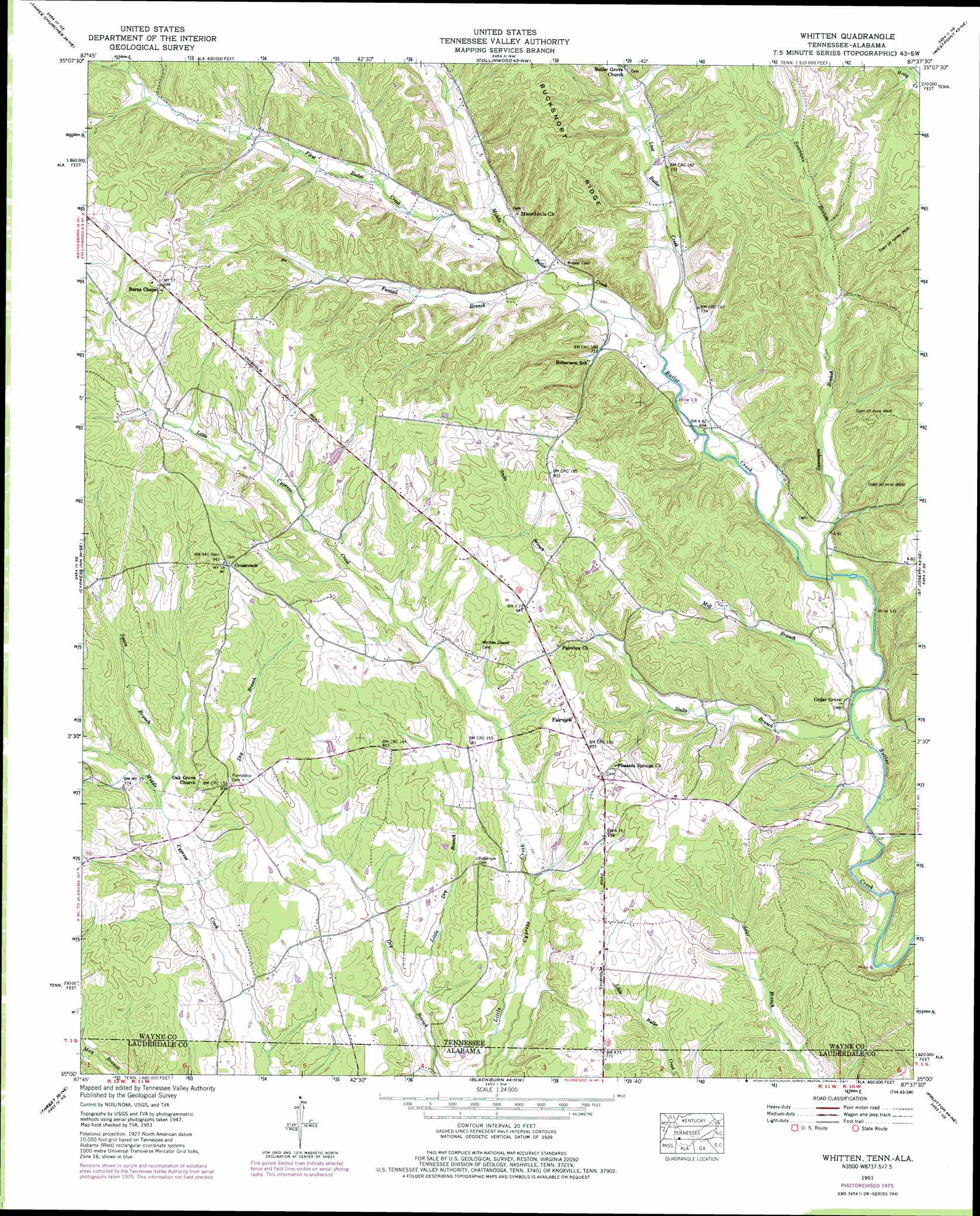
Whitten Topo Map Tennessee
To zoom in, hover over the map of Whitten
USGS Topo Quad 35087a6 - 1:24,000 scale
| Topo Map Name: | Whitten |
| USGS Topo Quad ID: | 35087a6 |
| Print Size: | ca. 21 1/4" wide x 27" high |
| Southeast Coordinates: | 35° N latitude / 87.625° W longitude |
| Map Center Coordinates: | 35.0625° N latitude / 87.6875° W longitude |
| U.S. States: | TN, AL |
| Filename: | o35087a6.jpg |
| Download Map JPG Image: | Whitten topo map 1:24,000 scale |
| Map Type: | Topographic |
| Topo Series: | 7.5´ |
| Map Scale: | 1:24,000 |
| Source of Map Images: | United States Geological Survey (USGS) |
| Alternate Map Versions: |
Light TN 1936 Download PDF Buy paper map Whitten TN 1951, updated 1954 Download PDF Buy paper map Whitten TN 1951, updated 1977 Download PDF Buy paper map Whitten TN 2010 Download PDF Buy paper map Whitten TN 2013 Download PDF Buy paper map Whitten TN 2016 Download PDF Buy paper map |
1:24,000 Topo Quads surrounding Whitten
Eagle Creek |
Waynesboro |
Negro Hollow |
Ovilla |
Deerfield |
Martins Mills |
Three Churches |
Collinwood |
Westpoint |
Long Branch |
Ransom Stand |
Cypress Inn |
Whitten |
Saint Joseph |
Loretto |
Wright |
Threet |
Blackburn |
Pruitton |
Center Hill |
Cherokee |
Sinking Creek |
Florence |
Killen |
Wheeler Dam |
> Back to 35087a1 at 1:100,000 scale
> Back to 35086a1 at 1:250,000 scale
> Back to U.S. Topo Maps home
Whitten topo map: Gazetteer
Whitten: Mines
Littrell-White Prospect elevation 250m 820′Lull Mine elevation 180m 590′
Robinson Mine elevation 255m 836′
Stults Prospect elevation 250m 820′
Whitten: Populated Places
Crossroads elevation 288m 944′Fairview elevation 250m 820′
Light (historical) elevation 210m 688′
Pleasant Valley (historical) elevation 258m 846′
Star (historical) elevation 230m 754′
Whitten: Streams
Fantail Branch elevation 211m 692′First Butler Creek elevation 213m 698′
Last Butler Creek elevation 204m 669′
Little Dry Branch elevation 201m 659′
Middle Butler Creek elevation 204m 669′
Mill Branch elevation 187m 613′
Spain Branch elevation 221m 725′
Stults Branch elevation 186m 610′
Swanegan Branch elevation 191m 626′
Whitten digital topo map on disk
Buy this Whitten topo map showing relief, roads, GPS coordinates and other geographical features, as a high-resolution digital map file on DVD: