Pulaski Topo Map Tennessee
To zoom in, hover over the map of Pulaski
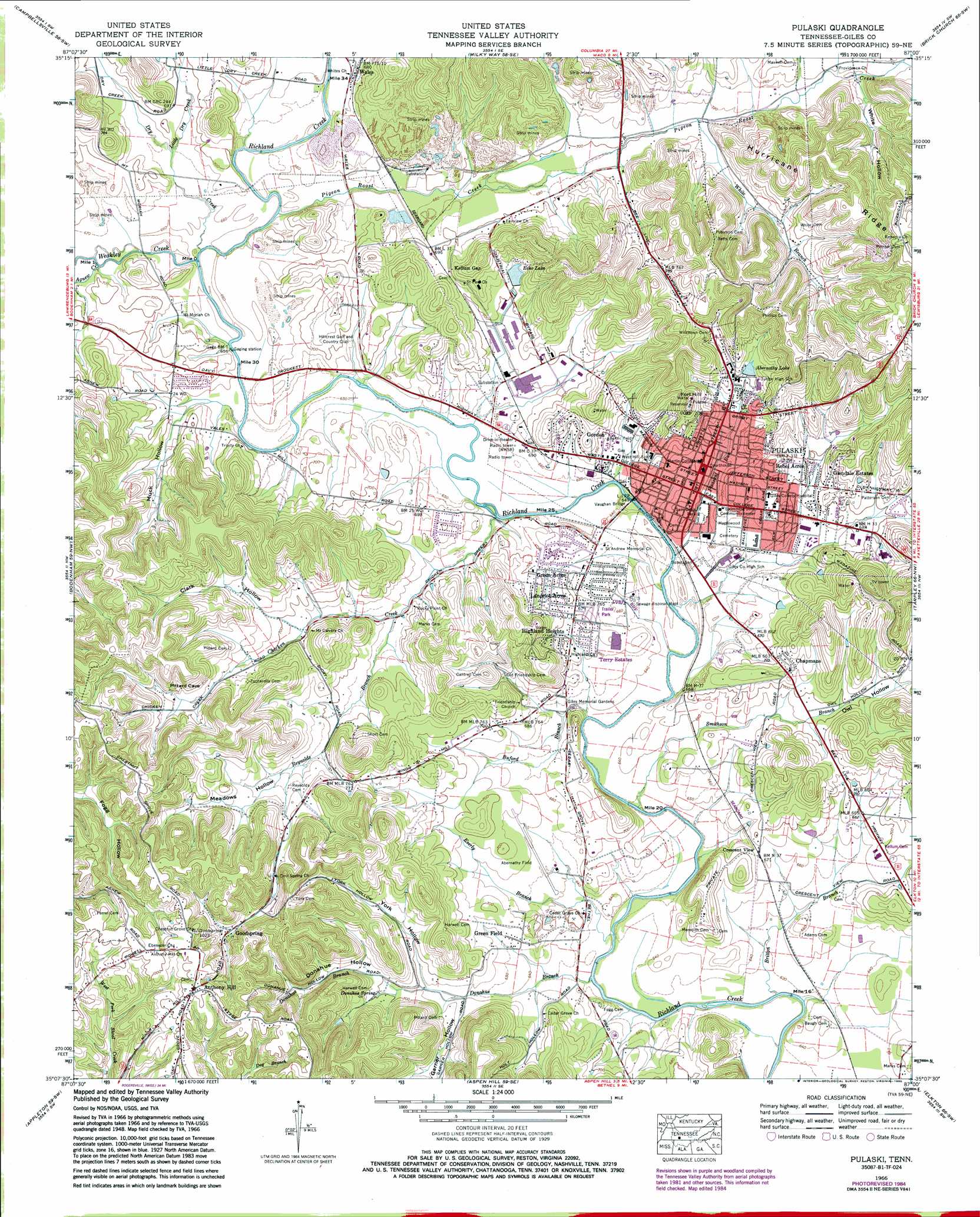
USGS Topo Quad 35087b1 - 1:24,000 scale
| Topo Map Name: | Pulaski |
| USGS Topo Quad ID: | 35087b1 |
| Print Size: | ca. 21 1/4" wide x 27" high |
| Southeast Coordinates: | 35.125° N latitude / 87° W longitude |
| Map Center Coordinates: | 35.1875° N latitude / 87.0625° W longitude |
| U.S. State: | TN |
| Filename: | o35087b1.jpg |
| Download Map JPG Image: | Pulaski topo map 1:24,000 scale |
| Map Type: | Topographic |
| Topo Series: | 7.5´ |
| Map Scale: | 1:24,000 |
| Source of Map Images: | United States Geological Survey (USGS) |
| Alternate Map Versions: |
Pulaski TN 1936 Download PDF Buy paper map Pulaski TN 1951 Download PDF Buy paper map Pulaski TN 1966, updated 1968 Download PDF Buy paper map Pulaski TN 1966, updated 1981 Download PDF Buy paper map Pulaski TN 1966, updated 1986 Download PDF Buy paper map Pulaski TN 2010 Download PDF Buy paper map Pulaski TN 2013 Download PDF Buy paper map Pulaski TN 2016 Download PDF Buy paper map |
1:24,000 Topo Quads surrounding Pulaski
Summertown |
Sandy Hook |
Lynnville |
Campbells Station |
Lewisburg |
Ethridge |
Campbellsville |
Milky Way |
Brick Church |
Cornersville |
Lawrenceburg |
Bodenham |
Pulaski |
Tarpley |
Frankewing |
Bonnertown |
Appleton |
Aspen Hill |
Elkton |
Dellrose |
Lexington |
Union Hill |
Salem |
Elkmont |
Ardmore |
> Back to 35087a1 at 1:100,000 scale
> Back to 35086a1 at 1:250,000 scale
> Back to U.S. Topo Maps home
Pulaski topo map: Gazetteer
Pulaski: Airports
Abernathy Field elevation 199m 652′Pulaski: Bridges
Vaughan Bridge elevation 196m 643′Pulaski: Dams
Echo Lake Dam elevation 216m 708′Lakeview Lake Dam elevation 223m 731′
Pulaski: Islands
Everly Island elevation 189m 620′Pulaski: Parks
Cave Springs Park elevation 217m 711′Magazine Road Park elevation 200m 656′
North End Park elevation 210m 688′
Pleasant Run Park elevation 201m 659′
Richland Park elevation 201m 659′
Sam Davis Park elevation 200m 656′
South Patterson Park elevation 198m 649′
Turner Park elevation 219m 718′
Victoria Park elevation 250m 820′
Washington Heights Park elevation 242m 793′
Pulaski: Populated Places
Anthony Hill elevation 308m 1010′Chapmans elevation 220m 721′
Cobb Subdivision elevation 245m 803′
Cole (historical) elevation 206m 675′
Crescent View elevation 206m 675′
Glendale Estates elevation 223m 731′
Goodspring elevation 253m 830′
Gordon elevation 207m 679′
Green Acres elevation 207m 679′
Green Field elevation 202m 662′
Highland Heights elevation 218m 715′
Lancelot Acres elevation 215m 705′
Pulaski elevation 213m 698′
Rebel Acres elevation 213m 698′
Richland Trace Subdivision elevation 208m 682′
Terry Estates elevation 212m 695′
Turney elevation 192m 629′
Wales elevation 207m 679′
Pulaski: Post Offices
Goodspring Post Office elevation 259m 849′Pulaski Post Office elevation 214m 702′
Pulaski: Reservoirs
Abernathy Lake elevation 219m 718′Echo Lake elevation 216m 708′
Lakeview Lake elevation 223m 731′
Pulaski: Springs
Donahue Spring elevation 213m 698′Town Springs elevation 213m 698′
Pulaski: Streams
Agnew Creek elevation 201m 659′Britton Branch elevation 189m 620′
Buford Branch elevation 191m 626′
Chicken Creek elevation 195m 639′
Donahue Branch elevation 189m 620′
Dry Creek elevation 198m 649′
Everly Branch elevation 189m 620′
Little Dry Creek elevation 204m 669′
Pigeon Roost Creek elevation 200m 656′
Pleasant Run Creek elevation 192m 629′
Reynolds Branch elevation 201m 659′
Smithson Branch elevation 189m 620′
Weakley Creek elevation 198m 649′
White Branch elevation 216m 708′
Pulaski: Summits
Fort Hill elevation 288m 944′Kings Mountain elevation 301m 987′
Pulaski: Valleys
Clark Hollow elevation 220m 721′Donahue Hollow elevation 207m 679′
Garner Hollow elevation 203m 666′
Garner Hollow elevation 216m 708′
Meadows Hollow elevation 217m 711′
Muck Hollow elevation 201m 659′
Owl Hollow elevation 209m 685′
Phillips Hollow elevation 204m 669′
White Hollow elevation 225m 738′
York Hollow elevation 208m 682′
Pulaski digital topo map on disk
Buy this Pulaski topo map showing relief, roads, GPS coordinates and other geographical features, as a high-resolution digital map file on DVD: