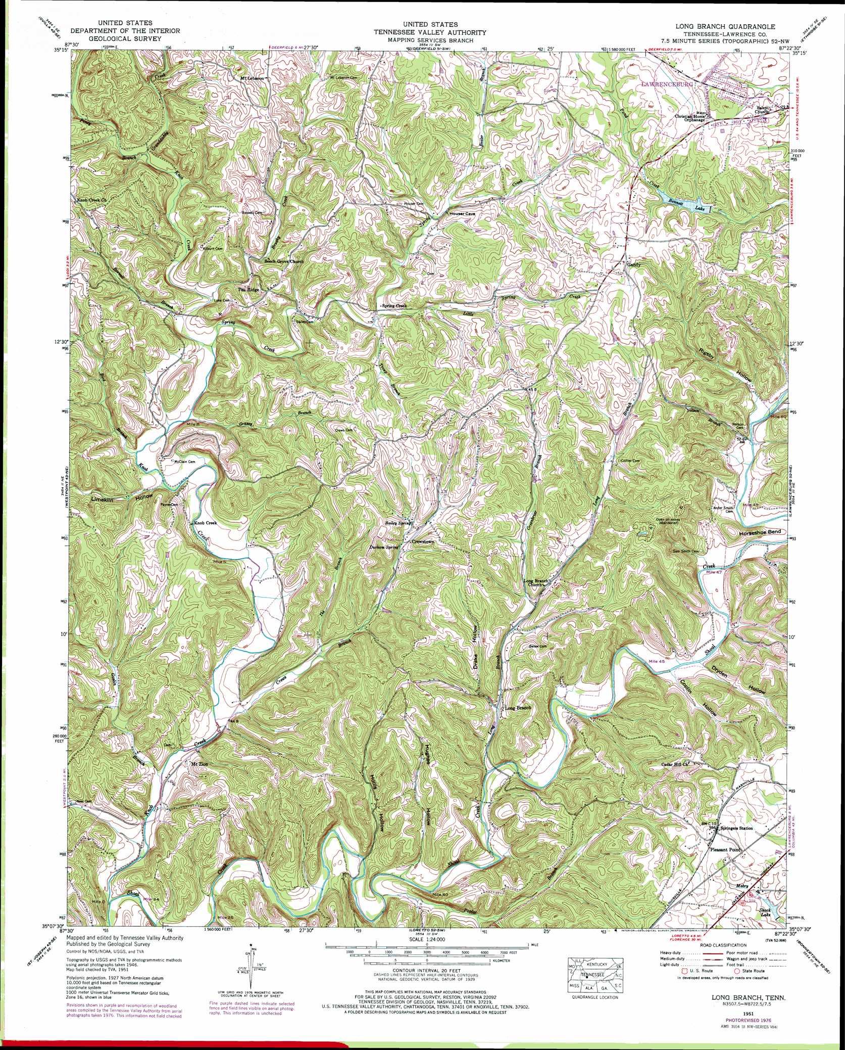
Long Branch Topo Map Tennessee
To zoom in, hover over the map of Long Branch
USGS Topo Quad 35087b4 - 1:24,000 scale
| Topo Map Name: | Long Branch |
| USGS Topo Quad ID: | 35087b4 |
| Print Size: | ca. 21 1/4" wide x 27" high |
| Southeast Coordinates: | 35.125° N latitude / 87.375° W longitude |
| Map Center Coordinates: | 35.1875° N latitude / 87.4375° W longitude |
| U.S. State: | TN |
| Filename: | o35087b4.jpg |
| Download Map JPG Image: | Long Branch topo map 1:24,000 scale |
| Map Type: | Topographic |
| Topo Series: | 7.5´ |
| Map Scale: | 1:24,000 |
| Source of Map Images: | United States Geological Survey (USGS) |
| Alternate Map Versions: |
Long Branch TN 1936 Download PDF Buy paper map Long Branch TN 1951, updated 1956 Download PDF Buy paper map Long Branch TN 1951, updated 1978 Download PDF Buy paper map Long Branch TN 2010 Download PDF Buy paper map Long Branch TN 2013 Download PDF Buy paper map Long Branch TN 2016 Download PDF Buy paper map |
1:24,000 Topo Quads surrounding Long Branch
Topsy |
Riverside |
Henryville |
Summertown |
Sandy Hook |
Negro Hollow |
Ovilla |
Deerfield |
Ethridge |
Campbellsville |
Collinwood |
Westpoint |
Long Branch |
Lawrenceburg |
Bodenham |
Whitten |
Saint Joseph |
Loretto |
Bonnertown |
Appleton |
Blackburn |
Pruitton |
Center Hill |
Lexington |
Union Hill |
> Back to 35087a1 at 1:100,000 scale
> Back to 35086a1 at 1:250,000 scale
> Back to U.S. Topo Maps home
Long Branch topo map: Gazetteer
Long Branch: Dams
Bennett Lake Dam elevation 259m 849′Shack Lake Dam elevation 262m 859′
Long Branch: Populated Places
Crewstown elevation 219m 718′Gandy elevation 287m 941′
Knob Creek elevation 202m 662′
Long Branch elevation 208m 682′
Mount Lebanon elevation 278m 912′
Mount Zion elevation 190m 623′
Pea Ridge elevation 257m 843′
Spring Creek elevation 233m 764′
Springers Station elevation 290m 951′
Long Branch: Reservoirs
Bennett Lake elevation 259m 849′Shack Lake elevation 262m 859′
Long Branch: Springs
Bailey Spring elevation 227m 744′Durham Spring elevation 223m 731′
Long Branch: Streams
Bealer Branch elevation 235m 770′Bird Branch elevation 197m 646′
Boswell Branch elevation 205m 672′
Brushy Creek elevation 207m 679′
Crews Branch elevation 183m 600′
Goslin Branch elevation 182m 597′
Granddaddy Creek elevation 213m 698′
Grassy Branch elevation 200m 656′
Greenbrier Branch elevation 213m 698′
Hollander Branch elevation 184m 603′
Ike Branch elevation 193m 633′
Knob Creek elevation 182m 597′
Little Spring Creek elevation 225m 738′
Long Branch elevation 194m 636′
Nelson Branch elevation 210m 688′
Piney Branch elevation 213m 698′
Poplar Branch elevation 189m 620′
Spring Creek elevation 203m 666′
Troup Branch elevation 225m 738′
Whitehouse Branch elevation 211m 692′
Long Branch: Valleys
Coplin Hollow elevation 206m 675′Drake Hollow elevation 207m 679′
Dryden Hollow elevation 206m 675′
Hollis Hollow elevation 187m 613′
Hughes Hollow elevation 202m 662′
Limekiln Hollow elevation 201m 659′
Rigsby Hollow elevation 211m 692′
Long Branch digital topo map on disk
Buy this Long Branch topo map showing relief, roads, GPS coordinates and other geographical features, as a high-resolution digital map file on DVD: