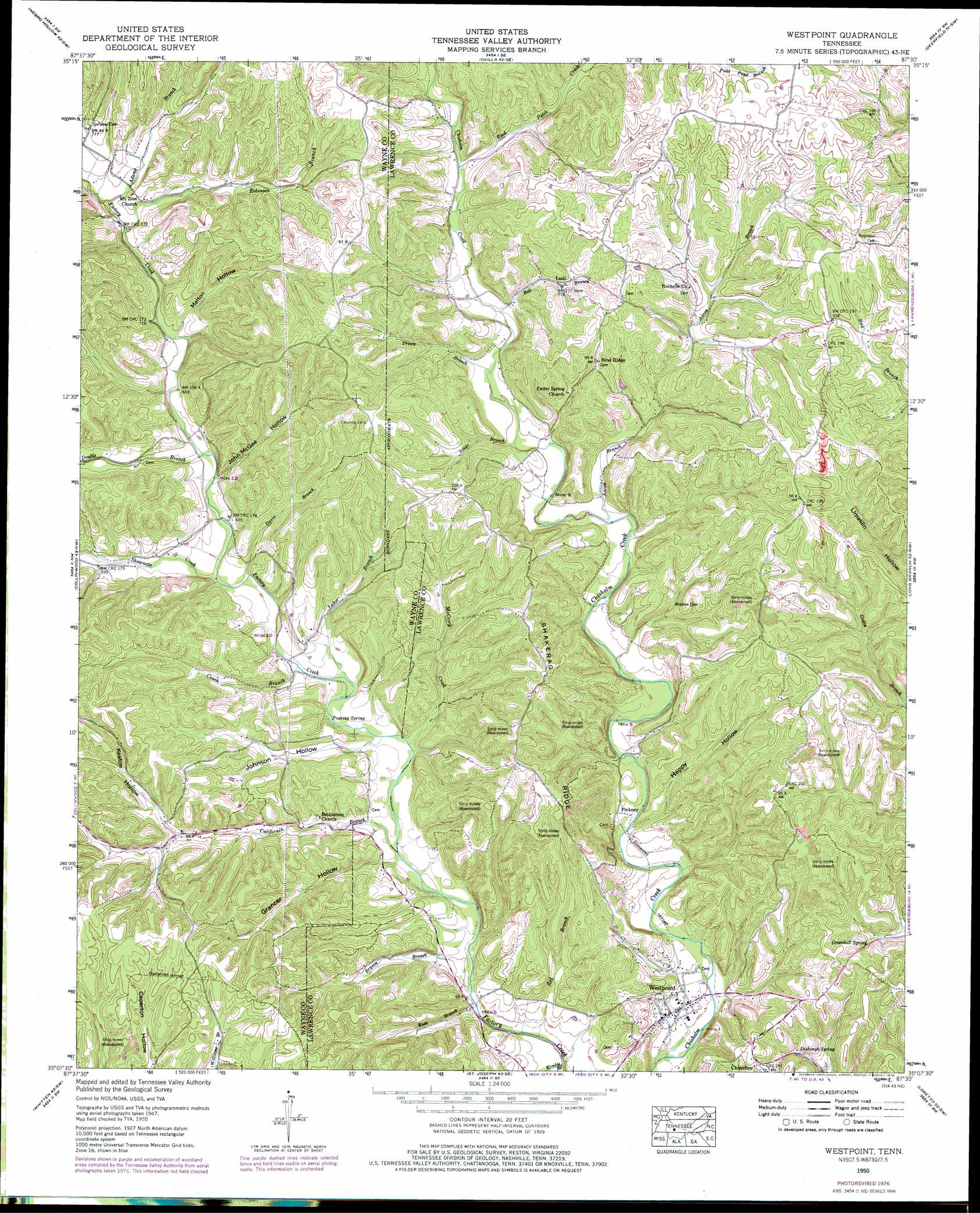
Westpoint Topo Map Tennessee
To zoom in, hover over the map of Westpoint
USGS Topo Quad 35087b5 - 1:24,000 scale
| Topo Map Name: | Westpoint |
| USGS Topo Quad ID: | 35087b5 |
| Print Size: | ca. 21 1/4" wide x 27" high |
| Southeast Coordinates: | 35.125° N latitude / 87.5° W longitude |
| Map Center Coordinates: | 35.1875° N latitude / 87.5625° W longitude |
| U.S. State: | TN |
| Filename: | o35087b5.jpg |
| Download Map JPG Image: | Westpoint topo map 1:24,000 scale |
| Map Type: | Topographic |
| Topo Series: | 7.5´ |
| Map Scale: | 1:24,000 |
| Source of Map Images: | United States Geological Survey (USGS) |
| Alternate Map Versions: |
Westpoint TN 1936 Download PDF Buy paper map Westpoint TN 1950, updated 1954 Download PDF Buy paper map Westpoint TN 1950, updated 1978 Download PDF Buy paper map Westpoint TN 2010 Download PDF Buy paper map Westpoint TN 2013 Download PDF Buy paper map Westpoint TN 2016 Download PDF Buy paper map |
1:24,000 Topo Quads surrounding Westpoint
Leatherwood |
Topsy |
Riverside |
Henryville |
Summertown |
Waynesboro |
Negro Hollow |
Ovilla |
Deerfield |
Ethridge |
Three Churches |
Collinwood |
Westpoint |
Long Branch |
Lawrenceburg |
Cypress Inn |
Whitten |
Saint Joseph |
Loretto |
Bonnertown |
Threet |
Blackburn |
Pruitton |
Center Hill |
Lexington |
> Back to 35087a1 at 1:100,000 scale
> Back to 35086a1 at 1:250,000 scale
> Back to U.S. Topo Maps home
Westpoint topo map: Gazetteer
Westpoint: Mines
Burkett Mine elevation 277m 908′Dodd Mine elevation 264m 866′
Drake Mine elevation 269m 882′
Gambrel Prospect elevation 274m 898′
Gresham Mine elevation 271m 889′
Hessemer Number One Mine elevation 270m 885′
Hessemer Number Two Mine elevation 262m 859′
Hopkins Prospect elevation 276m 905′
Ironsides Mine elevation 254m 833′
Little Hill Mine elevation 271m 889′
MacDonald-Robinson Prospect elevation 279m 915′
Pinkney Mine elevation 248m 813′
Sharp Mine elevation 278m 912′
Wisdom Mine elevation 278m 912′
Wright Mine elevation 274m 898′
Westpoint: Populated Places
Bethlehem elevation 199m 652′Hardwick Subdivision elevation 190m 623′
Lodi elevation 234m 767′
Pinkney elevation 200m 656′
Sims Ridge elevation 270m 885′
Westpoint elevation 190m 623′
Westpoint: Post Offices
Westpoint Post Office elevation 190m 623′Westpoint: Ridges
Shakerag Ridge elevation 260m 853′Westpoint: Springs
Dishongh Spring elevation 227m 744′Greenhall Spring elevation 211m 692′
Pouring Spring elevation 199m 652′
Westpoint: Streams
Aaron Branch elevation 207m 679′Adams Branch elevation 213m 698′
Ball Branch elevation 217m 711′
Bryson Branch elevation 184m 603′
California Branch elevation 192m 629′
Couch Branch elevation 194m 636′
Davis Branch elevation 199m 652′
Double Branch elevation 203m 666′
Kimble Branch elevation 183m 600′
Luker Branch elevation 193m 633′
McCrory Creek elevation 190m 623′
Prince Branch elevation 214m 702′
Red Branch elevation 183m 600′
Reed Patch Creek elevation 224m 734′
Robinson Branch elevation 213m 698′
Russ Branch elevation 184m 603′
Shawnette Creek elevation 200m 656′
Songo Branch elevation 212m 695′
Westpoint: Summits
Boarding House Hill elevation 201m 659′Westpoint: Valleys
Grancer Hollow elevation 191m 626′Happy Hollow elevation 193m 633′
John McGee Hollow elevation 205m 672′
Johnson Hollow elevation 193m 633′
Keaton Hollow elevation 217m 711′
Melton Hollow elevation 213m 698′
Westpoint digital topo map on disk
Buy this Westpoint topo map showing relief, roads, GPS coordinates and other geographical features, as a high-resolution digital map file on DVD: