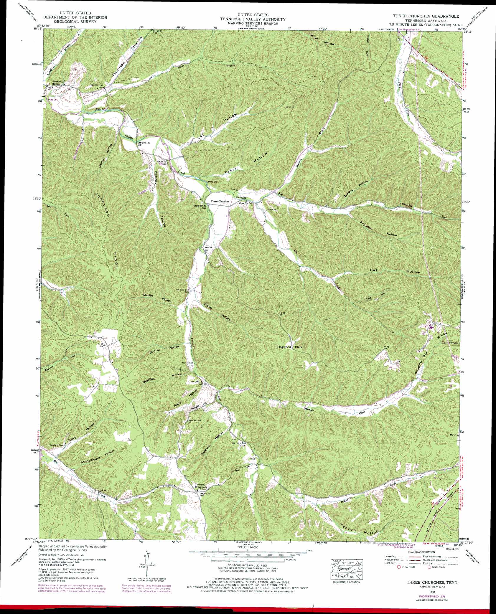
Three Churches Topo Map Tennessee
To zoom in, hover over the map of Three Churches
USGS Topo Quad 35087b7 - 1:24,000 scale
| Topo Map Name: | Three Churches |
| USGS Topo Quad ID: | 35087b7 |
| Print Size: | ca. 21 1/4" wide x 27" high |
| Southeast Coordinates: | 35.125° N latitude / 87.75° W longitude |
| Map Center Coordinates: | 35.1875° N latitude / 87.8125° W longitude |
| U.S. State: | TN |
| Filename: | o35087b7.jpg |
| Download Map JPG Image: | Three Churches topo map 1:24,000 scale |
| Map Type: | Topographic |
| Topo Series: | 7.5´ |
| Map Scale: | 1:24,000 |
| Source of Map Images: | United States Geological Survey (USGS) |
| Alternate Map Versions: |
Three Churches TN 1936 Download PDF Buy paper map Three Churches TN 1951, updated 1954 Download PDF Buy paper map Three Churches TN 1951, updated 1977 Download PDF Buy paper map Three Churches TN 2010 Download PDF Buy paper map Three Churches TN 2013 Download PDF Buy paper map Three Churches TN 2016 Download PDF Buy paper map |
1:24,000 Topo Quads surrounding Three Churches
Bath Springs |
Clifton |
Leatherwood |
Topsy |
Riverside |
Olivehill |
Eagle Creek |
Waynesboro |
Negro Hollow |
Ovilla |
Wolf Pit Ridge |
Martins Mills |
Three Churches |
Collinwood |
Westpoint |
Lowryville |
Ransom Stand |
Cypress Inn |
Whitten |
Saint Joseph |
Waterloo |
Wright |
Threet |
Blackburn |
Pruitton |
> Back to 35087a1 at 1:100,000 scale
> Back to 35086a1 at 1:250,000 scale
> Back to U.S. Topo Maps home
Three Churches topo map: Gazetteer
Three Churches: Flats
Dogwood Flats elevation 299m 980′Three Churches: Populated Places
Cromwell Crossroads elevation 299m 980′Victory (historical) elevation 214m 702′
Three Churches: Ridges
Copeland Ridge elevation 267m 875′Three Churches: Springs
Cave Spring elevation 188m 616′Three Churches: Streams
Cave Creek elevation 181m 593′Downing Branch elevation 189m 620′
Dry Creek elevation 186m 610′
Lay Hollow Branch elevation 177m 580′
Moser Branch elevation 171m 561′
Owl Hollow Branch elevation 206m 675′
Roanoke Creek elevation 205m 672′
Robinson Hollow Branch elevation 177m 580′
Waterfall Creek elevation 183m 600′
Three Churches: Summits
Baptist Hill elevation 238m 780′Blair Hill elevation 243m 797′
Dug Hill elevation 289m 948′
Three Churches: Valleys
Ayers Hollow elevation 202m 662′Ayers Hollow elevation 181m 593′
Berry Hollow elevation 219m 718′
Copus Hollow elevation 195m 639′
Cynthia Hollow elevation 202m 662′
Daniel Hollow elevation 177m 580′
Deerlick Hollow elevation 197m 646′
Downing Hollow elevation 189m 620′
Keeton Hollow elevation 237m 777′
Lay Hollow elevation 180m 590′
Martin Hollow elevation 195m 639′
Newburn Hollow elevation 215m 705′
Owl Hollow elevation 206m 675′
Robinson Hollow elevation 180m 590′
Schoolhouse Hollow elevation 225m 738′
Sherrill Hollow elevation 198m 649′
Shipman Hollow elevation 195m 639′
Slaughter Pen Hollow elevation 205m 672′
Thornton Hollow elevation 177m 580′
Three Churches digital topo map on disk
Buy this Three Churches topo map showing relief, roads, GPS coordinates and other geographical features, as a high-resolution digital map file on DVD: