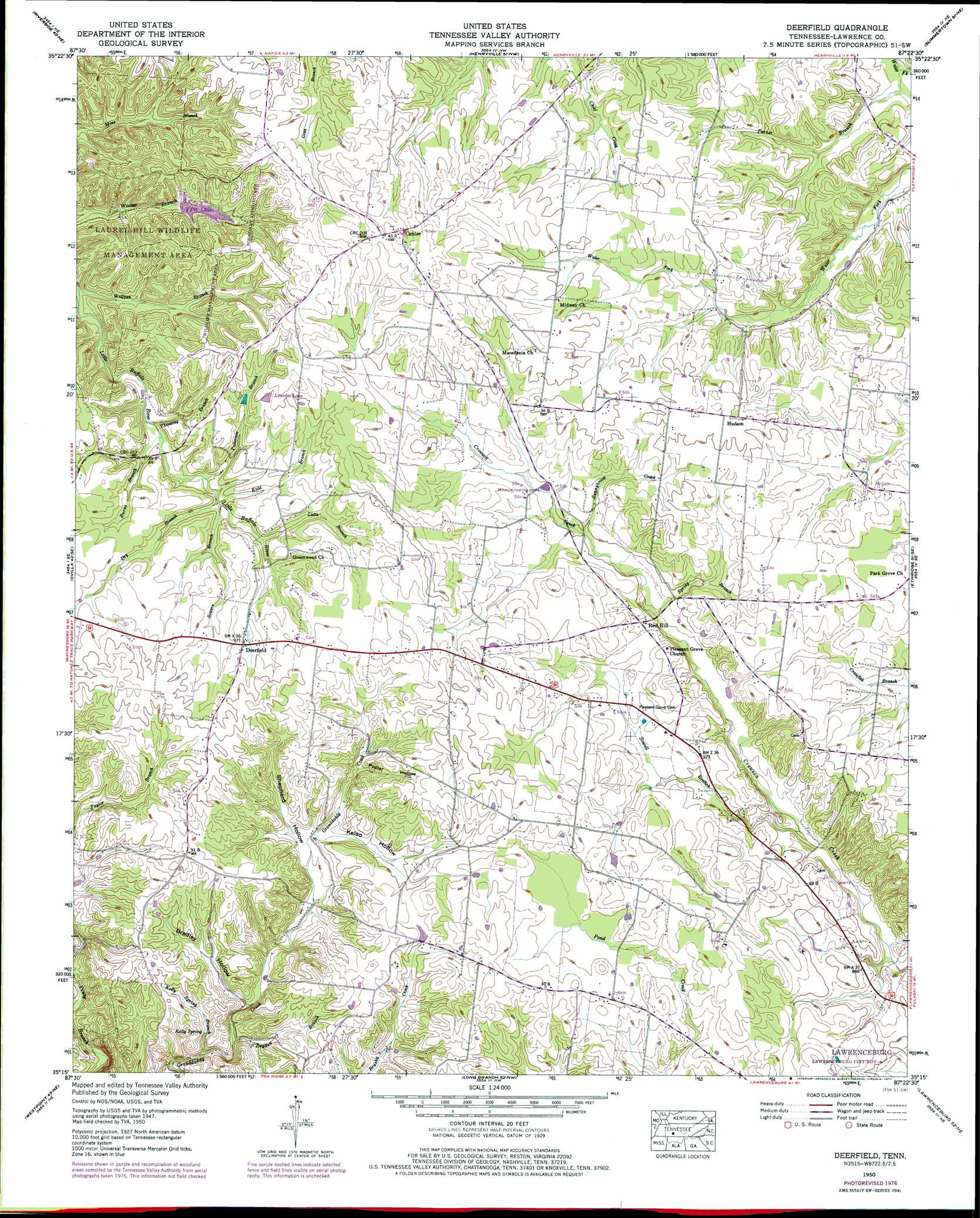
Deerfield Topo Map Tennessee
To zoom in, hover over the map of Deerfield
USGS Topo Quad 35087c4 - 1:24,000 scale
| Topo Map Name: | Deerfield |
| USGS Topo Quad ID: | 35087c4 |
| Print Size: | ca. 21 1/4" wide x 27" high |
| Southeast Coordinates: | 35.25° N latitude / 87.375° W longitude |
| Map Center Coordinates: | 35.3125° N latitude / 87.4375° W longitude |
| U.S. State: | TN |
| Filename: | o35087c4.jpg |
| Download Map JPG Image: | Deerfield topo map 1:24,000 scale |
| Map Type: | Topographic |
| Topo Series: | 7.5´ |
| Map Scale: | 1:24,000 |
| Source of Map Images: | United States Geological Survey (USGS) |
| Alternate Map Versions: |
Deerfield TN 1936 Download PDF Buy paper map Deerfield TN 1950, updated 1954 Download PDF Buy paper map Deerfield TN 1950, updated 1977 Download PDF Buy paper map Deerfield TN 2010 Download PDF Buy paper map Deerfield TN 2013 Download PDF Buy paper map Deerfield TN 2016 Download PDF Buy paper map |
1:24,000 Topo Quads surrounding Deerfield
Graves Spring |
Kimmins |
Gordonsburg |
Mount Joy |
Mount Pleasant |
Topsy |
Riverside |
Henryville |
Summertown |
Sandy Hook |
Negro Hollow |
Ovilla |
Deerfield |
Ethridge |
Campbellsville |
Collinwood |
Westpoint |
Long Branch |
Lawrenceburg |
Bodenham |
Whitten |
Saint Joseph |
Loretto |
Bonnertown |
Appleton |
> Back to 35087a1 at 1:100,000 scale
> Back to 35086a1 at 1:250,000 scale
> Back to U.S. Topo Maps home
Deerfield topo map: Gazetteer
Deerfield: Dams
Veterans of Foreign Wars Dam elevation 268m 879′Deerfield: Lakes
Lourdes Lake elevation 304m 997′VFW Lake elevation 277m 908′
Deerfield: Populated Places
Center elevation 316m 1036′Deerfield elevation 294m 964′
Hudson elevation 304m 997′
Red Hill elevation 279m 915′
Deerfield: Reservoirs
Veterans of Foreign Wars Lake elevation 268m 879′Deerfield: Springs
Kelly Spring elevation 242m 793′Deerfield: Streams
Burns Branch elevation 263m 862′Dry Branch elevation 268m 879′
Dryden Branch elevation 240m 787′
Kelly Spring Branch elevation 234m 767′
Kidd Branch elevation 268m 879′
Lutts Branch elevation 273m 895′
Parker Branch elevation 253m 830′
Patterson Branch elevation 267m 875′
Sowell Branch elevation 257m 843′
Sowers Branch elevation 269m 882′
Spring Branch elevation 268m 879′
Sunnybrook Creek elevation 273m 895′
Theasing Branch elevation 262m 859′
Wolfpen Branch elevation 252m 826′
Deerfield: Valleys
Bradley Hollow elevation 244m 800′Kilburn Hollow elevation 243m 797′
Deerfield digital topo map on disk
Buy this Deerfield topo map showing relief, roads, GPS coordinates and other geographical features, as a high-resolution digital map file on DVD: